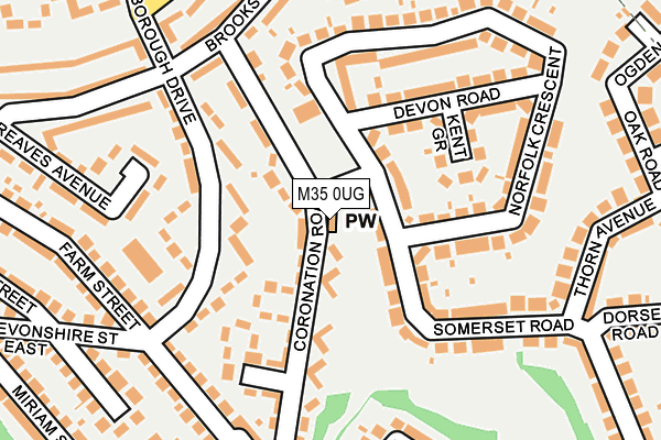
M35 0UG is located in the Failsworth West electoral ward, within the metropolitan district of Oldham and the English Parliamentary constituency of Ashton-under-Lyne. The Sub Integrated Care Board (ICB) Location is NHS Greater Manchester ICB - 00Y and the police force is Greater Manchester. This postcode has been in use since May 1994.


GetTheData
Source: OS OpenMap – Local (Ordnance Survey)
Source: OS VectorMap District (Ordnance Survey)
Licence: Open Government Licence (requires attribution)
| Easting | 389271 |
| Northing | 400594 |
| Latitude | 53.501945 |
| Longitude | -2.163216 |
GetTheData
Source: Open Postcode Geo
Licence: Open Government Licence
| Country | England |
| Postcode District | M35 |
| ➜ M35 open data dashboard ➜ See where M35 is on a map ➜ Where is Failsworth? | |
GetTheData
Source: Land Registry Price Paid Data
Licence: Open Government Licence
Elevation or altitude of M35 0UG as distance above sea level:
| Metres | Feet | |
|---|---|---|
| Elevation | 90m | 295ft |
Elevation is measured from the approximate centre of the postcode, to the nearest point on an OS contour line from OS Terrain 50, which has contour spacing of ten vertical metres.
➜ How high above sea level am I? Find the elevation of your current position using your device's GPS.
GetTheData
Source: Open Postcode Elevation
Licence: Open Government Licence
| Ward | Failsworth West |
| Constituency | Ashton-under-lyne |
GetTheData
Source: ONS Postcode Database
Licence: Open Government Licence
| June 2022 | Burglary | On or near Almond Close | 313m |
| ➜ Get more crime data in our Crime section | |||
GetTheData
Source: data.police.uk
Licence: Open Government Licence
| Coronation Road (E Bnd) (Coronation Road) | Failsworth | 27m |
| Somerset Road (E Bnd) (Somerset Road) | Failsworth | 51m |
| Somerset Road (E Bnd) (Somerset Road) | Failsworth | 137m |
| Brooks Dr (Ne Bnd) (Brooks Drive) | Failsworth | 197m |
| Marlborough Drive (N Bnd) (Marlborough Dr) | Failsworth | 209m |
| Failsworth (Manchester Metrolink) (Hardman Lane) | Failsworth | 965m |
| Newton Heath & Moston (Manchester Metrolink) (Dean Lane) | Newton Heath | 1,442m |
| Moston Station | 2.4km |
| Fairfield Station | 3.6km |
| Gorton Station | 3.7km |
GetTheData
Source: NaPTAN
Licence: Open Government Licence
GetTheData
Source: ONS Postcode Database
Licence: Open Government Licence


➜ Get more ratings from the Food Standards Agency
GetTheData
Source: Food Standards Agency
Licence: FSA terms & conditions
| Last Collection | |||
|---|---|---|---|
| Location | Mon-Fri | Sat | Distance |
| Moorside Street P.o. | 17:30 | 12:00 | 1,228m |
| Delmahoy Close | 17:30 | 12:00 | 1,396m |
| Scotland Hall Road | 17:30 | 12:00 | 1,466m |
GetTheData
Source: Dracos
Licence: Creative Commons Attribution-ShareAlike
| Facility | Distance |
|---|---|
| Bodyworx (Ladies Only) (Closed) Somerset Road, Failsworth, Manchester Health and Fitness Gym | 123m |
| Propps Hall School Propps Hall Drive, Failsworth, Manchester Artificial Grass Pitch | 410m |
| Brookdale Park Droylsden Road, Manchester Grass Pitches, Outdoor Tennis Courts | 561m |
GetTheData
Source: Active Places
Licence: Open Government Licence
| School | Phase of Education | Distance |
|---|---|---|
| St Mary's RC Primary School Clive Road, Failsworth, Manchester, M35 0NW | Primary | 391m |
| South Failsworth Community Primary School Paddock Lane, Failsworth, Manchester, M35 0NY | Primary | 401m |
| Propps Hall Junior Infant and Nursery School Propps Hall Drive, Failsworth, Manchester, M35 0ND | Primary | 410m |
GetTheData
Source: Edubase
Licence: Open Government Licence
The below table lists the International Territorial Level (ITL) codes (formerly Nomenclature of Territorial Units for Statistics (NUTS) codes) and Local Administrative Units (LAU) codes for M35 0UG:
| ITL 1 Code | Name |
|---|---|
| TLD | North West (England) |
| ITL 2 Code | Name |
| TLD3 | Greater Manchester |
| ITL 3 Code | Name |
| TLD37 | Greater Manchester North East |
| LAU 1 Code | Name |
| E08000004 | Oldham |
GetTheData
Source: ONS Postcode Directory
Licence: Open Government Licence
The below table lists the Census Output Area (OA), Lower Layer Super Output Area (LSOA), and Middle Layer Super Output Area (MSOA) for M35 0UG:
| Code | Name | |
|---|---|---|
| OA | E00027205 | |
| LSOA | E01005374 | Oldham 034C |
| MSOA | E02001131 | Oldham 034 |
GetTheData
Source: ONS Postcode Directory
Licence: Open Government Licence
| M35 0LT | Coronation Road | 67m |
| M35 0WR | Somerset Road | 84m |
| M35 0LX | Marlborough Drive | 85m |
| M35 0WT | Somerset Road | 100m |
| M35 0NT | Somerset Road | 123m |
| M35 0LU | Coronation Road | 126m |
| M35 0LY | Marlborough Drive | 140m |
| M35 0NL | Kent Grove | 147m |
| M35 0WQ | Somerset Road | 153m |
| M35 0WG | Norfolk Crescent | 161m |
GetTheData
Source: Open Postcode Geo; Land Registry Price Paid Data
Licence: Open Government Licence