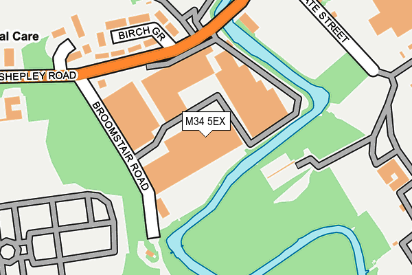
M34 5EX is located in the Audenshaw electoral ward, within the metropolitan district of Tameside and the English Parliamentary constituency of Denton and Reddish. The Sub Integrated Care Board (ICB) Location is NHS Greater Manchester ICB - 01Y and the police force is Greater Manchester. This postcode has been in use since July 1995.


GetTheData
Source: OS OpenMap – Local (Ordnance Survey)
Source: OS VectorMap District (Ordnance Survey)
Licence: Open Government Licence (requires attribution)
| Easting | 393091 |
| Northing | 396683 |
| Latitude | 53.466840 |
| Longitude | -2.105540 |
GetTheData
Source: Open Postcode Geo
Licence: Open Government Licence
| Country | England |
| Postcode District | M34 |
| ➜ M34 open data dashboard ➜ See where M34 is on a map ➜ Where is Audenshaw? | |
GetTheData
Source: Land Registry Price Paid Data
Licence: Open Government Licence
Elevation or altitude of M34 5EX as distance above sea level:
| Metres | Feet | |
|---|---|---|
| Elevation | 80m | 262ft |
Elevation is measured from the approximate centre of the postcode, to the nearest point on an OS contour line from OS Terrain 50, which has contour spacing of ten vertical metres.
➜ How high above sea level am I? Find the elevation of your current position using your device's GPS.
GetTheData
Source: Open Postcode Elevation
Licence: Open Government Licence
| Ward | Audenshaw |
| Constituency | Denton And Reddish |
GetTheData
Source: ONS Postcode Database
Licence: Open Government Licence
| Shepley Rd/Broomstair Rd (Shepley Rd) | Hooley Hill | 177m |
| Shepley Rd/Broomstair Rd (Shepley Rd) | Hooley Hill | 191m |
| Ashton St/Shepley Ind Est (Ashton St) | Hooley Hill | 197m |
| Ashton St/Shepley Ind Est (Ashton Street) | Hooley Hill | 289m |
| Cemetery Rd/Audenshaw Cemetery (Cemetery Rd) | Hooley Hill | 354m |
| Guide Bridge Station | 1km |
| Hyde North Station | 1.4km |
| Flowery Field Station | 1.7km |
GetTheData
Source: NaPTAN
Licence: Open Government Licence
GetTheData
Source: ONS Postcode Database
Licence: Open Government Licence


➜ Get more ratings from the Food Standards Agency
GetTheData
Source: Food Standards Agency
Licence: FSA terms & conditions
| Last Collection | |||
|---|---|---|---|
| Location | Mon-Fri | Sat | Distance |
| Stamford Road | 17:30 | 12:00 | 951m |
| Victoria Road | 17:45 | 12:00 | 1,030m |
| Boyds Walk | 17:30 | 11:30 | 1,111m |
GetTheData
Source: Dracos
Licence: Creative Commons Attribution-ShareAlike
| Facility | Distance |
|---|---|
| King George Playing Fields (Audenshaw) Mount Pleasant Street, Audenshaw Grass Pitches | 384m |
| Poplar Street Primary School Ravenwood Drive, Audenshaw, Manchester Grass Pitches | 699m |
| Audenshaw School Hazel Street, Audenshaw, Manchester Health and Fitness Gym, Artificial Grass Pitch, Grass Pitches, Sports Hall | 857m |
GetTheData
Source: Active Places
Licence: Open Government Licence
| School | Phase of Education | Distance |
|---|---|---|
| Poplar Street Primary School Ravenwood Drive, Audenshaw, Manchester, M34 5EF | Primary | 693m |
| Tameside Pupil Referral Service Globe Lane, Dukinfield, SK16 4UJ | Not applicable | 794m |
| Audenshaw School Hazel Street, Audenshaw, Manchester, M34 5NB | Secondary | 901m |
GetTheData
Source: Edubase
Licence: Open Government Licence
The below table lists the International Territorial Level (ITL) codes (formerly Nomenclature of Territorial Units for Statistics (NUTS) codes) and Local Administrative Units (LAU) codes for M34 5EX:
| ITL 1 Code | Name |
|---|---|
| TLD | North West (England) |
| ITL 2 Code | Name |
| TLD3 | Greater Manchester |
| ITL 3 Code | Name |
| TLD35 | Greater Manchester South East |
| LAU 1 Code | Name |
| E08000008 | Tameside |
GetTheData
Source: ONS Postcode Directory
Licence: Open Government Licence
The below table lists the Census Output Area (OA), Lower Layer Super Output Area (LSOA), and Middle Layer Super Output Area (MSOA) for M34 5EX:
| Code | Name | |
|---|---|---|
| OA | E00030195 | |
| LSOA | E01005965 | Tameside 019C |
| MSOA | E02001247 | Tameside 019 |
GetTheData
Source: ONS Postcode Directory
Licence: Open Government Licence
| M34 5DN | Birch Grove | 198m |
| M34 5DH | The Old Stables | 241m |
| M34 5DL | Shepley Road | 314m |
| M34 3TF | Old Meadow Drive | 360m |
| M34 5AH | Cemetery Road | 367m |
| M34 3TE | Linksfield | 383m |
| M34 3TS | Spinney Grove | 386m |
| M34 5DJ | Shepley Road | 394m |
| M34 3TT | Sandbrook Way | 418m |
| M34 5AF | Howard Street | 424m |
GetTheData
Source: Open Postcode Geo; Land Registry Price Paid Data
Licence: Open Government Licence