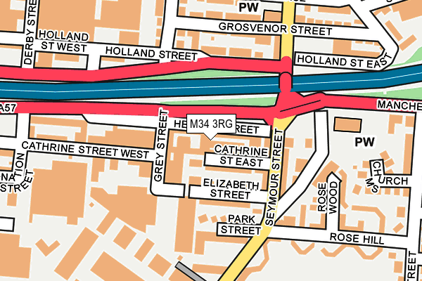
M34 3RG is located in the Denton West electoral ward, within the metropolitan district of Tameside and the English Parliamentary constituency of Denton and Reddish. The Sub Integrated Care Board (ICB) Location is NHS Greater Manchester ICB - 01Y and the police force is Greater Manchester. This postcode has been in use since June 1981.


GetTheData
Source: OS OpenMap – Local (Ordnance Survey)
Source: OS VectorMap District (Ordnance Survey)
Licence: Open Government Licence (requires attribution)
| Easting | 391808 |
| Northing | 395449 |
| Latitude | 53.455746 |
| Longitude | -2.124833 |
GetTheData
Source: Open Postcode Geo
Licence: Open Government Licence
| Country | England |
| Postcode District | M34 |
| ➜ M34 open data dashboard ➜ See where M34 is on a map ➜ Where is Denton? | |
GetTheData
Source: Land Registry Price Paid Data
Licence: Open Government Licence
Elevation or altitude of M34 3RG as distance above sea level:
| Metres | Feet | |
|---|---|---|
| Elevation | 90m | 295ft |
Elevation is measured from the approximate centre of the postcode, to the nearest point on an OS contour line from OS Terrain 50, which has contour spacing of ten vertical metres.
➜ How high above sea level am I? Find the elevation of your current position using your device's GPS.
GetTheData
Source: Open Postcode Elevation
Licence: Open Government Licence
| Ward | Denton West |
| Constituency | Denton And Reddish |
GetTheData
Source: ONS Postcode Database
Licence: Open Government Licence
| Manchester Rd South/Seymour St (Manchester Rd) | Denton | 60m |
| Manchester Rd South/Heaton St (Manchester Rd) | Denton | 139m |
| Manchester Rd North/Holland St (Manchester Rd N) | Denton | 141m |
| Seymour St/Belmont Ave (Seymour St) | Denton | 214m |
| Seymour Street (Sbd) (Seymour Street) | Denton | 226m |
| Denton Station | 0.5km |
| Reddish North Station | 2.2km |
| Fairfield Station | 2.2km |
GetTheData
Source: NaPTAN
Licence: Open Government Licence
GetTheData
Source: ONS Postcode Database
Licence: Open Government Licence


➜ Get more ratings from the Food Standards Agency
GetTheData
Source: Food Standards Agency
Licence: FSA terms & conditions
| Last Collection | |||
|---|---|---|---|
| Location | Mon-Fri | Sat | Distance |
| Cardinal Street | 17:30 | 11:45 | 1,360m |
| Stamford Road | 17:30 | 12:00 | 1,490m |
| Anchor Court | 17:30 | 12:00 | 1,519m |
GetTheData
Source: Dracos
Licence: Creative Commons Attribution-ShareAlike
| Facility | Distance |
|---|---|
| Betta Bodies Gym Heaton Street, Denton Health and Fitness Gym | 13m |
| Puregym (Denton) Oldham Street, Denton, Manchester Swimming Pool, Health and Fitness Gym, Studio | 314m |
| Windmill Lane Playing Field (Closed) Windmill Lane, Denton, Manchester Grass Pitches | 321m |
GetTheData
Source: Active Places
Licence: Open Government Licence
| School | Phase of Education | Distance |
|---|---|---|
| Denton Community College Taylor Lane, Denton, Manchester, M34 3NG | Secondary | 617m |
| Russell Scott Primary School Clare Street, Denton, Manchester, M34 3LQ | Primary | 636m |
| St Mary's RC Primary School Kynder Street, Denton, Manchester, M34 2AR | Primary | 758m |
GetTheData
Source: Edubase
Licence: Open Government Licence
The below table lists the International Territorial Level (ITL) codes (formerly Nomenclature of Territorial Units for Statistics (NUTS) codes) and Local Administrative Units (LAU) codes for M34 3RG:
| ITL 1 Code | Name |
|---|---|
| TLD | North West (England) |
| ITL 2 Code | Name |
| TLD3 | Greater Manchester |
| ITL 3 Code | Name |
| TLD35 | Greater Manchester South East |
| LAU 1 Code | Name |
| E08000008 | Tameside |
GetTheData
Source: ONS Postcode Directory
Licence: Open Government Licence
The below table lists the Census Output Area (OA), Lower Layer Super Output Area (LSOA), and Middle Layer Super Output Area (MSOA) for M34 3RG:
| Code | Name | |
|---|---|---|
| OA | E00030330 | |
| LSOA | E01005992 | Tameside 025D |
| MSOA | E02001253 | Tameside 025 |
GetTheData
Source: ONS Postcode Directory
Licence: Open Government Licence
| M34 3RQ | Cathrine Street East | 40m |
| M34 3RP | Elizabeth Street | 63m |
| M34 3RS | Park Street | 105m |
| M34 3RW | Seymour Street | 119m |
| M34 3PZ | Holland Street | 138m |
| M34 3RN | Windmill Lane | 144m |
| M34 3GA | Grosvenor Street | 164m |
| M34 3RY | Heaton Street | 181m |
| M34 3GR | Rosewood | 193m |
| M34 3SY | Catherine Street West | 198m |
GetTheData
Source: Open Postcode Geo; Land Registry Price Paid Data
Licence: Open Government Licence