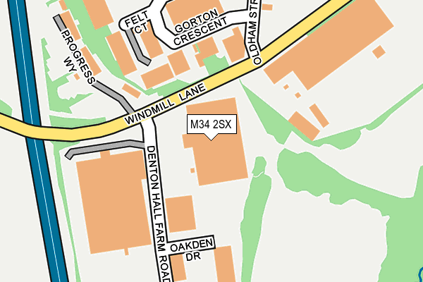
M34 2SX is located in the Denton West electoral ward, within the metropolitan district of Tameside and the English Parliamentary constituency of Denton and Reddish. The Sub Integrated Care Board (ICB) Location is NHS Greater Manchester ICB - 01Y and the police force is Greater Manchester. This postcode has been in use since November 2003.


GetTheData
Source: OS OpenMap – Local (Ordnance Survey)
Source: OS VectorMap District (Ordnance Survey)
Licence: Open Government Licence (requires attribution)
| Easting | 391374 |
| Northing | 394765 |
| Latitude | 53.449591 |
| Longitude | -2.131349 |
GetTheData
Source: Open Postcode Geo
Licence: Open Government Licence
| Country | England |
| Postcode District | M34 |
| ➜ M34 open data dashboard ➜ See where M34 is on a map ➜ Where is Denton? | |
GetTheData
Source: Land Registry Price Paid Data
Licence: Open Government Licence
Elevation or altitude of M34 2SX as distance above sea level:
| Metres | Feet | |
|---|---|---|
| Elevation | 90m | 295ft |
Elevation is measured from the approximate centre of the postcode, to the nearest point on an OS contour line from OS Terrain 50, which has contour spacing of ten vertical metres.
➜ How high above sea level am I? Find the elevation of your current position using your device's GPS.
GetTheData
Source: Open Postcode Elevation
Licence: Open Government Licence
| Ward | Denton West |
| Constituency | Denton And Reddish |
GetTheData
Source: ONS Postcode Database
Licence: Open Government Licence
| Oldham St/Gorton Cres (Oldham Rd) | Denton | 213m |
| Sainsbury's Car Park (Sainsburys C Pk) | Denton | 588m |
| Town Lane/Ruskin Avenue (Town Lane) | Denton | 614m |
| Town Lane/Auburn Road (Town Lane) | Circular Road Estate | 630m |
| City Ave/Town Ln (City Ave) | Denton | 666m |
| Denton Station | 0.8km |
| Reddish North Station | 1.7km |
| Brinnington Station | 2km |
GetTheData
Source: NaPTAN
Licence: Open Government Licence
GetTheData
Source: ONS Postcode Database
Licence: Open Government Licence


➜ Get more ratings from the Food Standards Agency
GetTheData
Source: Food Standards Agency
Licence: FSA terms & conditions
| Last Collection | |||
|---|---|---|---|
| Location | Mon-Fri | Sat | Distance |
| Anchor Court | 17:30 | 12:00 | 1,105m |
| Hazelbottom Road | 17:30 | 11:45 | 1,298m |
| Cardinal Street | 17:30 | 11:45 | 1,352m |
GetTheData
Source: Dracos
Licence: Creative Commons Attribution-ShareAlike
| Facility | Distance |
|---|---|
| Jackson Gardens Playing Fields (Closed) Jackson Gardens, Denton, Manchester Grass Pitches | 291m |
| Puregym (Denton) Oldham Street, Denton, Manchester Swimming Pool, Health and Fitness Gym, Studio | 562m |
| Windmill Lane Playing Field (Closed) Windmill Lane, Denton, Manchester Grass Pitches | 707m |
GetTheData
Source: Active Places
Licence: Open Government Licence
| School | Phase of Education | Distance |
|---|---|---|
| Greswell Primary School and Nursery Percy Road, Denton, Manchester, M34 2DH | Primary | 805m |
| St Thomas More RC College Town Lane, Denton, Manchester, M34 6AF | Secondary | 1.1km |
| Denton West End Primary School Balmoral Drive, Denton, Manchester, M34 2JX | Primary | 1.1km |
GetTheData
Source: Edubase
Licence: Open Government Licence
The below table lists the International Territorial Level (ITL) codes (formerly Nomenclature of Territorial Units for Statistics (NUTS) codes) and Local Administrative Units (LAU) codes for M34 2SX:
| ITL 1 Code | Name |
|---|---|
| TLD | North West (England) |
| ITL 2 Code | Name |
| TLD3 | Greater Manchester |
| ITL 3 Code | Name |
| TLD35 | Greater Manchester South East |
| LAU 1 Code | Name |
| E08000008 | Tameside |
GetTheData
Source: ONS Postcode Directory
Licence: Open Government Licence
The below table lists the Census Output Area (OA), Lower Layer Super Output Area (LSOA), and Middle Layer Super Output Area (MSOA) for M34 2SX:
| Code | Name | |
|---|---|---|
| OA | E00030353 | |
| LSOA | E01005989 | Tameside 025C |
| MSOA | E02001253 | Tameside 025 |
GetTheData
Source: ONS Postcode Directory
Licence: Open Government Licence
| M34 3RB | Windmill Lane Industrial Estate | 336m |
| M34 2EH | Jackson Gardens | 396m |
| M34 2DG | Kennedy Way | 403m |
| M34 2DR | Kennedy Way | 429m |
| M34 2DE | Coppice Walk | 467m |
| M34 2DP | Heathfield Avenue | 469m |
| M34 2PQ | Thompson Close | 470m |
| M34 2QA | Ashbrook Close | 478m |
| M34 2DQ | Millbrook Avenue | 481m |
| M34 2DT | Warren Close | 499m |
GetTheData
Source: Open Postcode Geo; Land Registry Price Paid Data
Licence: Open Government Licence