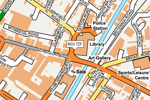
M33 7ZF is located in the Sale Central electoral ward, within the metropolitan district of Trafford and the English Parliamentary constituency of Wythenshawe and Sale East. The Sub Integrated Care Board (ICB) Location is NHS Greater Manchester ICB - 02A and the police force is Greater Manchester. This postcode has been in use since May 1994.


GetTheData
Source: OS OpenMap – Local (Ordnance Survey)
Source: OS VectorMap District (Ordnance Survey)
Licence: Open Government Licence (requires attribution)
| Easting | 378833 |
| Northing | 392083 |
| Latitude | 53.425111 |
| Longitude | -2.320000 |
GetTheData
Source: Open Postcode Geo
Licence: Open Government Licence
| Country | England |
| Postcode District | M33 |
| ➜ M33 open data dashboard ➜ See where M33 is on a map ➜ Where is Sale? | |
GetTheData
Source: Land Registry Price Paid Data
Licence: Open Government Licence
Elevation or altitude of M33 7ZF as distance above sea level:
| Metres | Feet | |
|---|---|---|
| Elevation | 30m | 98ft |
Elevation is measured from the approximate centre of the postcode, to the nearest point on an OS contour line from OS Terrain 50, which has contour spacing of ten vertical metres.
➜ How high above sea level am I? Find the elevation of your current position using your device's GPS.
GetTheData
Source: Open Postcode Elevation
Licence: Open Government Licence
| Ward | Sale Central |
| Constituency | Wythenshawe And Sale East |
GetTheData
Source: ONS Postcode Database
Licence: Open Government Licence
| School Road/Springfield Road (School Road) | Sale | 45m |
| School Road/Sale Tram Stop (School Road) | Sale | 66m |
| Springfield Road/School Road (Springfield Rd) | Sale | 92m |
| Ashfield Road/Claremont Road (Ashfield Road) | Sale | 97m |
| Sale Tram Stop (School Road) | Sale | 109m |
| Sale (Manchester Metrolink) (Off School Road) | Sale | 113m |
| Dane Road (Manchester Metrolink) (Dane Road) | Sale | 812m |
| Brooklands (Manchester Metrolink) (Brooklands Road) | Brooklands | 945m |
| Humphrey Park Station | 3.1km |
| Trafford Park Station | 3.4km |
| Urmston Station | 3.4km |
GetTheData
Source: NaPTAN
Licence: Open Government Licence
GetTheData
Source: ONS Postcode Database
Licence: Open Government Licence


➜ Get more ratings from the Food Standards Agency
GetTheData
Source: Food Standards Agency
Licence: FSA terms & conditions
| Last Collection | |||
|---|---|---|---|
| Location | Mon-Fri | Sat | Distance |
| Northenden Road P.o. | 17:30 | 12:00 | 211m |
| Sainsbury's | 17:30 | 12:00 | 216m |
| Outside Co-op | 231m | ||
GetTheData
Source: Dracos
Licence: Creative Commons Attribution-ShareAlike
| Facility | Distance |
|---|---|
| Snap Fitness (Manchester Sale) Springfield Road, Springfield Road, Sale Health and Fitness Gym | 160m |
| Sale Leisure Centre Broad Road, Sale Sports Hall, Swimming Pool, Health and Fitness Gym, Studio, Squash Courts | 274m |
| Everlast Gyms (Sale) Washway Road, Sale Swimming Pool, Health and Fitness Gym, Studio | 408m |
GetTheData
Source: Active Places
Licence: Open Government Licence
| School | Phase of Education | Distance |
|---|---|---|
| Springfield Primary School Springfield Road, Sale, M33 7XS | Primary | 130m |
| St Joseph's Catholic Primary School, a Voluntary Academy Marlborough Road, Sale, M33 3AF | Primary | 325m |
| Forest Park Preparatory School 27 Oakfield, Ashton-upon-Mersey, Sale, M33 6NB | Not applicable | 672m |
GetTheData
Source: Edubase
Licence: Open Government Licence
The below table lists the International Territorial Level (ITL) codes (formerly Nomenclature of Territorial Units for Statistics (NUTS) codes) and Local Administrative Units (LAU) codes for M33 7ZF:
| ITL 1 Code | Name |
|---|---|
| TLD | North West (England) |
| ITL 2 Code | Name |
| TLD3 | Greater Manchester |
| ITL 3 Code | Name |
| TLD34 | Greater Manchester South West |
| LAU 1 Code | Name |
| E08000009 | Trafford |
GetTheData
Source: ONS Postcode Directory
Licence: Open Government Licence
The below table lists the Census Output Area (OA), Lower Layer Super Output Area (LSOA), and Middle Layer Super Output Area (MSOA) for M33 7ZF:
| Code | Name | |
|---|---|---|
| OA | E00031231 | |
| LSOA | E01006160 | Trafford 015B |
| MSOA | E02001273 | Trafford 015 |
GetTheData
Source: ONS Postcode Directory
Licence: Open Government Licence
| M33 7XF | School Road | 60m |
| M33 7XY | School Road | 64m |
| M33 7DZ | Claremont Road | 77m |
| M33 7DY | 96m | |
| M33 7DF | Oriel Court | 98m |
| M33 7ZD | School Road | 120m |
| M33 7EE | Tatton Road | 128m |
| M33 7LN | Claremont Road | 139m |
| M33 7EF | Claremont Road | 149m |
| M33 2AE | Broad Road | 150m |
GetTheData
Source: Open Postcode Geo; Land Registry Price Paid Data
Licence: Open Government Licence