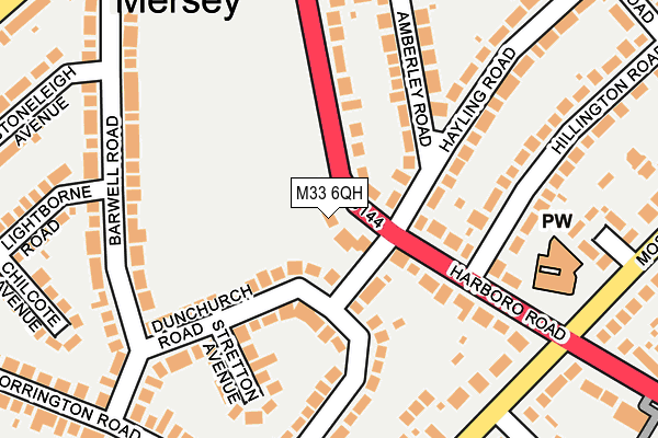
M33 6QH lies on Harboro Road in Sale. M33 6QH is located in the Manor electoral ward, within the metropolitan district of Trafford and the English Parliamentary constituency of Altrincham and Sale West. The Sub Integrated Care Board (ICB) Location is NHS Greater Manchester ICB - 02A and the police force is Greater Manchester. This postcode has been in use since May 1994.


GetTheData
Source: OS OpenMap – Local (Ordnance Survey)
Source: OS VectorMap District (Ordnance Survey)
Licence: Open Government Licence (requires attribution)
| Easting | 377289 |
| Northing | 391967 |
| Latitude | 53.424004 |
| Longitude | -2.343227 |
GetTheData
Source: Open Postcode Geo
Licence: Open Government Licence
| Street | Harboro Road |
| Town/City | Sale |
| Country | England |
| Postcode District | M33 |
| ➜ M33 open data dashboard ➜ See where M33 is on a map ➜ Where is Sale? | |
GetTheData
Source: Land Registry Price Paid Data
Licence: Open Government Licence
Elevation or altitude of M33 6QH as distance above sea level:
| Metres | Feet | |
|---|---|---|
| Elevation | 20m | 66ft |
Elevation is measured from the approximate centre of the postcode, to the nearest point on an OS contour line from OS Terrain 50, which has contour spacing of ten vertical metres.
➜ How high above sea level am I? Find the elevation of your current position using your device's GPS.
GetTheData
Source: Open Postcode Elevation
Licence: Open Government Licence
| Ward | Manor |
| Constituency | Altrincham And Sale West |
GetTheData
Source: ONS Postcode Database
Licence: Open Government Licence
2018 19 JAN £641,000 |
2010 5 NOV £610,000 |
1999 12 NOV £236,250 |
1998 20 OCT £250,000 |
GetTheData
Source: HM Land Registry Price Paid Data
Licence: Contains HM Land Registry data © Crown copyright and database right 2024. This data is licensed under the Open Government Licence v3.0.
| Moss Lane (Swbnd) (Moss Lane) | Sale | 232m |
| Firs Road/Dawlish Road (Firs Road) | Sale | 352m |
| Firs Road/Okehampton Crescent (Firs Road) | Sale | 356m |
| Firs Road/Okehampton Crescent (Firs Road) | Sale | 364m |
| Moss Lane (Nebnd) (Moss Lane) | Sale | 383m |
| Brooklands (Manchester Metrolink) (Brooklands Road) | Brooklands | 1,369m |
| Urmston Station | 2.8km |
| Chassen Road Station | 3km |
| Navigation Road Station | 3.2km |
GetTheData
Source: NaPTAN
Licence: Open Government Licence
| Percentage of properties with Next Generation Access | 100.0% |
| Percentage of properties with Superfast Broadband | 100.0% |
| Percentage of properties with Ultrafast Broadband | 100.0% |
| Percentage of properties with Full Fibre Broadband | 0.0% |
Superfast Broadband is between 30Mbps and 300Mbps
Ultrafast Broadband is > 300Mbps
| Percentage of properties unable to receive 2Mbps | 0.0% |
| Percentage of properties unable to receive 5Mbps | 0.0% |
| Percentage of properties unable to receive 10Mbps | 0.0% |
| Percentage of properties unable to receive 30Mbps | 0.0% |
GetTheData
Source: Ofcom
Licence: Ofcom Terms of Use (requires attribution)
GetTheData
Source: ONS Postcode Database
Licence: Open Government Licence


➜ Get more ratings from the Food Standards Agency
GetTheData
Source: Food Standards Agency
Licence: FSA terms & conditions
| Last Collection | |||
|---|---|---|---|
| Location | Mon-Fri | Sat | Distance |
| 53 Moss Lane | 17:30 | 12:00 | 234m |
| 45 Firs Road | 17:30 | 12:00 | 341m |
| Taunton Road / Winchester Dr | 17:30 | 12:00 | 495m |
GetTheData
Source: Dracos
Licence: Creative Commons Attribution-ShareAlike
| Facility | Distance |
|---|---|
| Weathercock Farm Firs Road, Sale Grass Pitches | 274m |
| Firs Primary School Firs Road, Sale Grass Pitches, Sports Hall | 522m |
| Ashton On Mersey Health And Fitness Centre Cecil Avenue, Sale Sports Hall, Health and Fitness Gym, Grass Pitches, Studio, Artificial Grass Pitch, Outdoor Tennis Courts | 545m |
GetTheData
Source: Active Places
Licence: Open Government Licence
| School | Phase of Education | Distance |
|---|---|---|
| Ashton-on-Mersey School Cecil Avenue, Sale, M33 5BP | Secondary | 573m |
| Firs Primary School Firs Road, Sale, M33 5EL | Primary | 615m |
| Wellfield Infant and Nursery School Church Lane, Sale, M33 5QW | Primary | 639m |
GetTheData
Source: Edubase
Licence: Open Government Licence
The below table lists the International Territorial Level (ITL) codes (formerly Nomenclature of Territorial Units for Statistics (NUTS) codes) and Local Administrative Units (LAU) codes for M33 6QH:
| ITL 1 Code | Name |
|---|---|
| TLD | North West (England) |
| ITL 2 Code | Name |
| TLD3 | Greater Manchester |
| ITL 3 Code | Name |
| TLD34 | Greater Manchester South West |
| LAU 1 Code | Name |
| E08000009 | Trafford |
GetTheData
Source: ONS Postcode Directory
Licence: Open Government Licence
The below table lists the Census Output Area (OA), Lower Layer Super Output Area (LSOA), and Middle Layer Super Output Area (MSOA) for M33 6QH:
| Code | Name | |
|---|---|---|
| OA | E00031267 | |
| LSOA | E01006172 | Trafford 016E |
| MSOA | E02001274 | Trafford 016 |
GetTheData
Source: ONS Postcode Directory
Licence: Open Government Licence
| M33 6GF | Harboro Road | 103m |
| M33 5FD | Dunchurch Road | 106m |
| M33 6GE | Harboro Road | 129m |
| M33 5ED | Dunchurch Road | 132m |
| M33 6QP | Amberley Road | 149m |
| M33 5EG | Stretton Avenue | 155m |
| M33 5EE | Barwell Road | 182m |
| M33 5AR | Moss Lane | 197m |
| M33 5DU | Kenilworth Road | 205m |
| M33 6GN | Hayling Road | 208m |
GetTheData
Source: Open Postcode Geo; Land Registry Price Paid Data
Licence: Open Government Licence