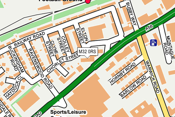
M32 0RS is located in the Gorse Hill & Cornbrook electoral ward, within the metropolitan district of Trafford and the English Parliamentary constituency of Stretford and Urmston. The Sub Integrated Care Board (ICB) Location is NHS Greater Manchester ICB - 02A and the police force is Greater Manchester. This postcode has been in use since September 1991.


GetTheData
Source: OS OpenMap – Local (Ordnance Survey)
Source: OS VectorMap District (Ordnance Survey)
Licence: Open Government Licence (requires attribution)
| Easting | 380802 |
| Northing | 396005 |
| Latitude | 53.460439 |
| Longitude | -2.290611 |
GetTheData
Source: Open Postcode Geo
Licence: Open Government Licence
| Country | England |
| Postcode District | M32 |
| ➜ M32 open data dashboard ➜ See where M32 is on a map ➜ Where is Old Trafford? | |
GetTheData
Source: Land Registry Price Paid Data
Licence: Open Government Licence
Elevation or altitude of M32 0RS as distance above sea level:
| Metres | Feet | |
|---|---|---|
| Elevation | 30m | 98ft |
Elevation is measured from the approximate centre of the postcode, to the nearest point on an OS contour line from OS Terrain 50, which has contour spacing of ten vertical metres.
➜ How high above sea level am I? Find the elevation of your current position using your device's GPS.
GetTheData
Source: Open Postcode Elevation
Licence: Open Government Licence
| Ward | Gorse Hill & Cornbrook |
| Constituency | Stretford And Urmston |
GetTheData
Source: ONS Postcode Database
Licence: Open Government Licence
| March 2022 | Violence and sexual offences | On or near Sports/Recreation Area | 300m |
| November 2021 | Violence and sexual offences | On or near Barlow Road | 185m |
| ➜ Get more crime data in our Crime section | |||
GetTheData
Source: data.police.uk
Licence: Open Government Licence
| Chester Road/Tesco (Chester Road) | Old Trafford | 56m |
| Chester Road/Warwick Road (Chester Road) | Old Trafford | 72m |
| Chester Road/Tesco (Chester Road) | Old Trafford | 78m |
| Chester Road/Warwick Road (Chester Road) | Old Trafford | 112m |
| Chester Road/Warwick Road (Chester Road) | Old Trafford | 116m |
| Old Trafford (Manchester Metrolink) (Trafford Park Road) | Old Trafford | 588m |
| Exchange Quay (Manchester Metrolink) (Exchange Quay) | Salford Quays | 925m |
| Trafford Bar (Manchester Metrolink) (Seymour Grove) | Trafford Bar | 933m |
| Pomona (Manchester Metrolink) (Pomona Strand) | Salford Quays | 969m |
| Salford Quays (Manchester Metrolink) (St Peters Quay) | Salford Quays | 1,175m |
| Manchester United FC Station | 0.2km |
| Trafford Park Station | 1.5km |
| Humphrey Park Station | 2.6km |
GetTheData
Source: NaPTAN
Licence: Open Government Licence
GetTheData
Source: ONS Postcode Database
Licence: Open Government Licence


➜ Get more ratings from the Food Standards Agency
GetTheData
Source: Food Standards Agency
Licence: FSA terms & conditions
| Last Collection | |||
|---|---|---|---|
| Location | Mon-Fri | Sat | Distance |
| Warwick Road | 17:30 | 12:00 | 139m |
| Avondale Road | 17:30 | 12:00 | 362m |
| 66 Talbot Road/Botanical Gdns | 17:30 | 11:45 | 524m |
GetTheData
Source: Dracos
Licence: Creative Commons Attribution-ShareAlike
| Facility | Distance |
|---|---|
| Manchester United (Old Trafford) Sir Matt Busby Way, Manchester Grass Pitches | 238m |
| Stretford Sports Village (Chester Centre) Great Stone Road, Stretford, Manchester Sports Hall, Swimming Pool, Health and Fitness Gym, Squash Courts | 277m |
| Trafford College Talbot Road, Stretford, Manchester Health and Fitness Gym | 327m |
GetTheData
Source: Active Places
Licence: Open Government Licence
| School | Phase of Education | Distance |
|---|---|---|
| Stretford High School Great Stone Road, Stretford, Manchester, M32 0XA | Secondary | 414m |
| Gorse Hill Primary School Burleigh Road, Stretford, Manchester, M32 0PF | Primary | 707m |
| Kings Road Primary School Kings Road, Firswood, Manchester, M16 0GR | Primary | 973m |
GetTheData
Source: Edubase
Licence: Open Government Licence
The below table lists the International Territorial Level (ITL) codes (formerly Nomenclature of Territorial Units for Statistics (NUTS) codes) and Local Administrative Units (LAU) codes for M32 0RS:
| ITL 1 Code | Name |
|---|---|
| TLD | North West (England) |
| ITL 2 Code | Name |
| TLD3 | Greater Manchester |
| ITL 3 Code | Name |
| TLD34 | Greater Manchester South West |
| LAU 1 Code | Name |
| E08000009 | Trafford |
GetTheData
Source: ONS Postcode Directory
Licence: Open Government Licence
The below table lists the Census Output Area (OA), Lower Layer Super Output Area (LSOA), and Middle Layer Super Output Area (MSOA) for M32 0RS:
| Code | Name | |
|---|---|---|
| OA | E00031368 | |
| LSOA | E01006186 | Trafford 003B |
| MSOA | E02001261 | Trafford 003 |
GetTheData
Source: ONS Postcode Directory
Licence: Open Government Licence
| M32 0SD | Elton Street | 76m |
| M32 0SB | Colley Street | 80m |
| M32 0SA | Clyne Street | 119m |
| M32 0RY | Railway Road | 120m |
| M32 0RQ | Hornby Road | 124m |
| M32 0RZ | Railway Road | 155m |
| M32 0RT | Ravenswood Road | 168m |
| M32 0RG | Barlow Road | 168m |
| M32 0SF | Chester Road | 169m |
| M32 0SE | Partridge Street | 181m |
GetTheData
Source: Open Postcode Geo; Land Registry Price Paid Data
Licence: Open Government Licence