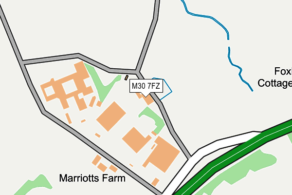
M30 7FZ is located in the Higher Irlam & Peel Green electoral ward, within the metropolitan district of Salford and the English Parliamentary constituency of Worsley and Eccles South. The Sub Integrated Care Board (ICB) Location is NHS Greater Manchester ICB - 01G and the police force is Greater Manchester. This postcode has been in use since July 1995.


GetTheData
Source: OS OpenMap – Local (Ordnance Survey)
Source: OS VectorMap District (Ordnance Survey)
Licence: Open Government Licence (requires attribution)
| Easting | 373925 |
| Northing | 396943 |
| Latitude | 53.468573 |
| Longitude | -2.394262 |
GetTheData
Source: Open Postcode Geo
Licence: Open Government Licence
| Country | England |
| Postcode District | M30 |
| ➜ M30 open data dashboard ➜ See where M30 is on a map | |
GetTheData
Source: Land Registry Price Paid Data
Licence: Open Government Licence
Elevation or altitude of M30 7FZ as distance above sea level:
| Metres | Feet | |
|---|---|---|
| Elevation | 20m | 66ft |
Elevation is measured from the approximate centre of the postcode, to the nearest point on an OS contour line from OS Terrain 50, which has contour spacing of ten vertical metres.
➜ How high above sea level am I? Find the elevation of your current position using your device's GPS.
GetTheData
Source: Open Postcode Elevation
Licence: Open Government Licence
| Ward | Higher Irlam & Peel Green |
| Constituency | Worsley And Eccles South |
GetTheData
Source: ONS Postcode Database
Licence: Open Government Licence
| Liverpool Rd/Barton Moss Rd (Liverpool Rd) | Barton Moss | 196m |
| Liverpool Rd/Barton Moss Rd (Liverpool Rd) | Barton Moss | 268m |
| Liverpool Rd/Barton Aerodrome (Liverpool Rd) | Barton Aerodrome | 515m |
| Liverpool Rd/Boysnope Farm (Liverpool Rd) | Irlam | 775m |
| Liverpool Rd/Boysnope Farm (Liverpool Rd) | Irlam | 829m |
| Flixton Station | 2.8km |
| Patricroft Station | 3km |
| Chassen Road Station | 3km |
GetTheData
Source: NaPTAN
Licence: Open Government Licence
GetTheData
Source: ONS Postcode Database
Licence: Open Government Licence


➜ Get more ratings from the Food Standards Agency
GetTheData
Source: Food Standards Agency
Licence: FSA terms & conditions
| Last Collection | |||
|---|---|---|---|
| Location | Mon-Fri | Sat | Distance |
| Bent Lane | 17:30 | 11:30 | 1,240m |
| Eddisbury Avenue | 17:30 | 11:30 | 1,242m |
| 190 Daveyhulme Road / Lowood Ave | 17:30 | 11:30 | 1,638m |
GetTheData
Source: Dracos
Licence: Creative Commons Attribution-ShareAlike
| Facility | Distance |
|---|---|
| Boysnope Park Golf Club (Closed) Liverpool Road, Eccles, Manchester Golf | 765m |
| Multifit Salford Stadium Way, Eccles, Manchester Health and Fitness Gym | 1.2km |
| Salford Red Devils (Aj Bell Stadium) Stadium Way, Eccles, Manchester Grass Pitches, Artificial Grass Pitch | 1.3km |
GetTheData
Source: Active Places
Licence: Open Government Licence
| School | Phase of Education | Distance |
|---|---|---|
| Barton Moss Community Primary School Trippier Road, Peel Green, Eccles, Manchester, M30 7PT | Primary | 1.3km |
| Salford City Academy Northfleet Road, Peel Green, Eccles, Manchester, M30 7PQ | Secondary | 1.4km |
| Woodhouse Primary School Nursery Road, Davyhulme, Urmston, Manchester, M41 7WW | Primary | 1.9km |
GetTheData
Source: Edubase
Licence: Open Government Licence
The below table lists the International Territorial Level (ITL) codes (formerly Nomenclature of Territorial Units for Statistics (NUTS) codes) and Local Administrative Units (LAU) codes for M30 7FZ:
| ITL 1 Code | Name |
|---|---|
| TLD | North West (England) |
| ITL 2 Code | Name |
| TLD3 | Greater Manchester |
| ITL 3 Code | Name |
| TLD34 | Greater Manchester South West |
| LAU 1 Code | Name |
| E08000006 | Salford |
GetTheData
Source: ONS Postcode Directory
Licence: Open Government Licence
The below table lists the Census Output Area (OA), Lower Layer Super Output Area (LSOA), and Middle Layer Super Output Area (MSOA) for M30 7FZ:
| Code | Name | |
|---|---|---|
| OA | E00029033 | |
| LSOA | E01005732 | Salford 025D |
| MSOA | E02001181 | Salford 025 |
GetTheData
Source: ONS Postcode Directory
Licence: Open Government Licence
| M30 7RJ | Liverpool Road | 214m |
| M30 7SF | Port Salford Way | 434m |
| M30 7RQ | Barton Moss Road | 452m |
| M30 7WE | Trident Road | 896m |
| M30 7RF | Liverpool Road | 900m |
| M30 7WF | Proctor Way | 945m |
| M30 7WH | Avroe Road | 946m |
| M30 7RR | Barton Moss Road | 953m |
| M30 7WG | Vanguard Close | 974m |
| M30 7NG | Avian Close | 1005m |
GetTheData
Source: Open Postcode Geo; Land Registry Price Paid Data
Licence: Open Government Licence