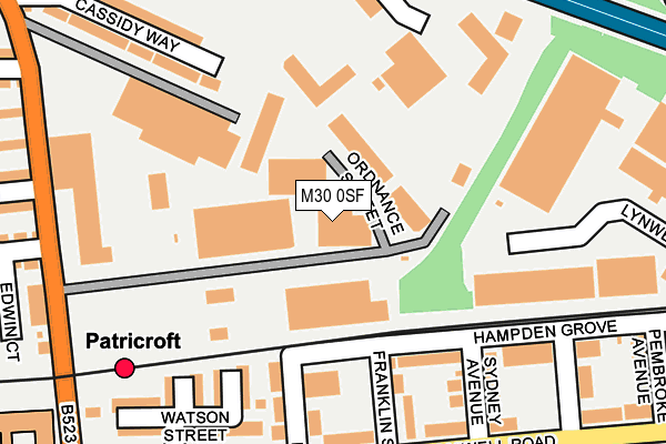
M30 0SF is located in the Eccles electoral ward, within the metropolitan district of Salford and the English Parliamentary constituency of Salford and Eccles. The Sub Integrated Care Board (ICB) Location is NHS Greater Manchester ICB - 01G and the police force is Greater Manchester. This postcode has been in use since July 1995.


GetTheData
Source: OS OpenMap – Local (Ordnance Survey)
Source: OS VectorMap District (Ordnance Survey)
Licence: Open Government Licence (requires attribution)
| Easting | 376563 |
| Northing | 398867 |
| Latitude | 53.485991 |
| Longitude | -2.354668 |
GetTheData
Source: Open Postcode Geo
Licence: Open Government Licence
| Country | England |
| Postcode District | M30 |
| ➜ M30 open data dashboard ➜ See where M30 is on a map ➜ Where is Eccles? | |
GetTheData
Source: Land Registry Price Paid Data
Licence: Open Government Licence
Elevation or altitude of M30 0SF as distance above sea level:
| Metres | Feet | |
|---|---|---|
| Elevation | 30m | 98ft |
Elevation is measured from the approximate centre of the postcode, to the nearest point on an OS contour line from OS Terrain 50, which has contour spacing of ten vertical metres.
➜ How high above sea level am I? Find the elevation of your current position using your device's GPS.
GetTheData
Source: Open Postcode Elevation
Licence: Open Government Licence
| Ward | Eccles |
| Constituency | Salford And Eccles |
GetTheData
Source: ONS Postcode Database
Licence: Open Government Licence
| February 2022 | Violence and sexual offences | On or near Lynwood Avenue | 488m |
| June 2021 | Violence and sexual offences | On or near King Edward Street | 341m |
| ➜ Get more crime data in our Crime section | |||
GetTheData
Source: data.police.uk
Licence: Open Government Licence
| Green Ln/Patricroft Stn (Green Ln) | Patricroft | 268m |
| Green Ln/Business Park (Green Ln) | Patricroft | 273m |
| Green Ln/Business Park (Green Ln) | Patricroft | 292m |
| Green Ln/Patricroft Stn (Green Ln) | Patricroft | 300m |
| Liverpool Rd/Shakespeare Cres (Liverpool Rd) | Patricroft | 380m |
| Eccles (Manchester Metrolink) (Regent Street) | Eccles | 1,336m |
| Patricroft Station | 0.3km |
| Eccles Station | 1.3km |
| Moorside Station | 3.4km |
GetTheData
Source: NaPTAN
Licence: Open Government Licence
Estimated total energy consumption in M30 0SF by fuel type, 2015.
| Consumption (kWh) | 221,982 |
|---|---|
| Meter count | 6 |
| Mean (kWh/meter) | 36,997 |
| Median (kWh/meter) | 36,334 |
GetTheData
Source: Postcode level gas estimates: 2015 (experimental)
Source: Postcode level electricity estimates: 2015 (experimental)
Licence: Open Government Licence
GetTheData
Source: ONS Postcode Database
Licence: Open Government Licence


➜ Get more ratings from the Food Standards Agency
GetTheData
Source: Food Standards Agency
Licence: FSA terms & conditions
| Last Collection | |||
|---|---|---|---|
| Location | Mon-Fri | Sat | Distance |
| Montonfields | 17:30 | 12:00 | 249m |
| Monton P.o. | 17:30 | 12:00 | 518m |
| 7 Stafford Road | 17:30 | 12:00 | 754m |
GetTheData
Source: Dracos
Licence: Creative Commons Attribution-ShareAlike
| Facility | Distance |
|---|---|
| Barton Athletic Club Franklin Street, Eccles Health and Fitness Gym | 147m |
| Lewis Street Playing Field Lewis Street, Eccles, Manchester Grass Pitches | 515m |
| Barton Athletic Club (Closed) Dorning Street, Eccles, Manchester Health and Fitness Gym | 517m |
GetTheData
Source: Active Places
Licence: Open Government Licence
| School | Phase of Education | Distance |
|---|---|---|
| Christ Church CofE Primary School Nelson Street, Patricroft, Eccles, Manchester, M30 0GZ | Primary | 335m |
| New Park Academy Off Green Lane, Patricroft, Eccles, M30 0RW | Not applicable | 350m |
| Brambles School 29 Ashworth Lane, Mottram, SK14 6NT | Not applicable | 633m |
GetTheData
Source: Edubase
Licence: Open Government Licence
The below table lists the International Territorial Level (ITL) codes (formerly Nomenclature of Territorial Units for Statistics (NUTS) codes) and Local Administrative Units (LAU) codes for M30 0SF:
| ITL 1 Code | Name |
|---|---|
| TLD | North West (England) |
| ITL 2 Code | Name |
| TLD3 | Greater Manchester |
| ITL 3 Code | Name |
| TLD34 | Greater Manchester South West |
| LAU 1 Code | Name |
| E08000006 | Salford |
GetTheData
Source: ONS Postcode Directory
Licence: Open Government Licence
The below table lists the Census Output Area (OA), Lower Layer Super Output Area (LSOA), and Middle Layer Super Output Area (MSOA) for M30 0SF:
| Code | Name | |
|---|---|---|
| OA | E00028533 | |
| LSOA | E01005632 | Salford 020B |
| MSOA | E02001176 | Salford 020 |
GetTheData
Source: ONS Postcode Directory
Licence: Open Government Licence
| M30 0QY | Hampden Grove | 148m |
| M30 0UQ | Wesley Street | 167m |
| M30 0QZ | Franklin Street | 204m |
| M30 0RB | Cromwell Road | 209m |
| M30 0UR | Wycliffe Street | 210m |
| M30 0BX | Sydney Avenue | 214m |
| M30 0RF | Watson Street | 231m |
| M30 0GZ | Nelson Street | 236m |
| M30 0RR | Nelson Street | 238m |
| M30 0GX | Cromwell Road | 256m |
GetTheData
Source: Open Postcode Geo; Land Registry Price Paid Data
Licence: Open Government Licence