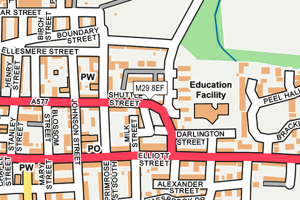
M29 8EF lies on Underwood Terrace in Tyldesley, Manchester. M29 8EF is located in the Tyldesley & Mosley Common electoral ward, within the metropolitan district of Wigan and the English Parliamentary constituency of Leigh. The Sub Integrated Care Board (ICB) Location is NHS Greater Manchester ICB - 02H and the police force is Greater Manchester. This postcode has been in use since May 1994.


GetTheData
Source: OS OpenMap – Local (Ordnance Survey)
Source: OS VectorMap District (Ordnance Survey)
Licence: Open Government Licence (requires attribution)
| Easting | 369360 |
| Northing | 402142 |
| Latitude | 53.515072 |
| Longitude | -2.463535 |
GetTheData
Source: Open Postcode Geo
Licence: Open Government Licence
| Street | Underwood Terrace |
| Locality | Tyldesley |
| Town/City | Manchester |
| Country | England |
| Postcode District | M29 |
| ➜ M29 open data dashboard ➜ See where M29 is on a map ➜ Where is Tyldesley? | |
GetTheData
Source: Land Registry Price Paid Data
Licence: Open Government Licence
Elevation or altitude of M29 8EF as distance above sea level:
| Metres | Feet | |
|---|---|---|
| Elevation | 50m | 164ft |
Elevation is measured from the approximate centre of the postcode, to the nearest point on an OS contour line from OS Terrain 50, which has contour spacing of ten vertical metres.
➜ How high above sea level am I? Find the elevation of your current position using your device's GPS.
GetTheData
Source: Open Postcode Elevation
Licence: Open Government Licence
| Ward | Tyldesley & Mosley Common |
| Constituency | Leigh |
GetTheData
Source: ONS Postcode Database
Licence: Open Government Licence
| June 2022 | Public order | On or near Birch Street | 254m |
| ➜ Get more crime data in our Crime section | |||
GetTheData
Source: data.police.uk
Licence: Open Government Licence
| Market St/Tyldesley Town Hall (Market St) | Tyldesley | 124m |
| Shuttle St/Tyldesley Police Stn (Shuttle St) | Tyldesley | 162m |
| Manchester Rd/Peel Hall Ave (Manchester Rd) | Tyldesley | 223m |
| Stanley St/Meanley St (Stanley St) | Tyldesley | 284m |
| Astley St | Tyldesley | 286m |
| Atherton Station | 1.9km |
| Hag Fold Station | 2.9km |
| Daisy Hill Station | 4.4km |
GetTheData
Source: NaPTAN
Licence: Open Government Licence
| Percentage of properties with Next Generation Access | 100.0% |
| Percentage of properties with Superfast Broadband | 100.0% |
| Percentage of properties with Ultrafast Broadband | 100.0% |
| Percentage of properties with Full Fibre Broadband | 0.0% |
Superfast Broadband is between 30Mbps and 300Mbps
Ultrafast Broadband is > 300Mbps
| Percentage of properties unable to receive 2Mbps | 0.0% |
| Percentage of properties unable to receive 5Mbps | 0.0% |
| Percentage of properties unable to receive 10Mbps | 0.0% |
| Percentage of properties unable to receive 30Mbps | 0.0% |
GetTheData
Source: Ofcom
Licence: Ofcom Terms of Use (requires attribution)
GetTheData
Source: ONS Postcode Database
Licence: Open Government Licence


➜ Get more ratings from the Food Standards Agency
GetTheData
Source: Food Standards Agency
Licence: FSA terms & conditions
| Last Collection | |||
|---|---|---|---|
| Location | Mon-Fri | Sat | Distance |
| Bodmin Road / Truro Road | 17:30 | 11:30 | 1,158m |
| Tesco Crabtree M29 0ag | 17:30 | 11:30 | 1,915m |
| Mossley Common P.o. | 17:30 | 12:00 | 2,707m |
GetTheData
Source: Dracos
Licence: Creative Commons Attribution-ShareAlike
| Facility | Distance |
|---|---|
| St George's Central C Of E Primary School And Nursery Darlington Street, Tyldesley, Manchester Grass Pitches | 125m |
| Unit 7 Gym Poplar Street, Tyldesley, Manchester Health and Fitness Gym | 257m |
| Puregym (Tyldesley) Castle Street, Tyldesley, Manchester Health and Fitness Gym | 476m |
GetTheData
Source: Active Places
Licence: Open Government Licence
| School | Phase of Education | Distance |
|---|---|---|
| Tyldesley St George's Central CofE Primary School and Nursery Darlington Street, Tyldesley, Manchester, M29 8DH | Primary | 124m |
| Cambian Tyldesley School Shuttle Street, Tyldesley, Wigan, Manchester, M29 8BS | Not applicable | 172m |
| Progress Schools - Lilford Centre The Lilford Centre, Lancaster Avenue, Tyldesley, Wigan, M29 8LN | Not applicable | 652m |
GetTheData
Source: Edubase
Licence: Open Government Licence
The below table lists the International Territorial Level (ITL) codes (formerly Nomenclature of Territorial Units for Statistics (NUTS) codes) and Local Administrative Units (LAU) codes for M29 8EF:
| ITL 1 Code | Name |
|---|---|
| TLD | North West (England) |
| ITL 2 Code | Name |
| TLD3 | Greater Manchester |
| ITL 3 Code | Name |
| TLD36 | Greater Manchester North West |
| LAU 1 Code | Name |
| E08000010 | Wigan |
GetTheData
Source: ONS Postcode Directory
Licence: Open Government Licence
The below table lists the Census Output Area (OA), Lower Layer Super Output Area (LSOA), and Middle Layer Super Output Area (MSOA) for M29 8EF:
| Code | Name | |
|---|---|---|
| OA | E00031902 | |
| LSOA | E01006294 | Wigan 025B |
| MSOA | E02001311 | Wigan 025 |
GetTheData
Source: ONS Postcode Directory
Licence: Open Government Licence
| M29 8GF | Beckford Court | 35m |
| M29 8BG | Shuttle Street | 58m |
| M29 8DQ | Milk Street | 58m |
| M29 8DB | Brindle Street | 65m |
| M29 8DF | Common Lane | 70m |
| M29 8DE | Robinson Street | 73m |
| M29 8FD | Kershaw Street | 74m |
| M29 8DA | Holt Street | 80m |
| M29 8BQ | Primrose Street North | 92m |
| M29 8DG | Elliott Street | 98m |
GetTheData
Source: Open Postcode Geo; Land Registry Price Paid Data
Licence: Open Government Licence