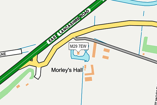
M29 7EW is located in the Astley electoral ward, within the metropolitan district of Wigan and the English Parliamentary constituency of Leigh. The Sub Integrated Care Board (ICB) Location is NHS Greater Manchester ICB - 02H and the police force is Greater Manchester. This postcode has been in use since January 1980.


GetTheData
Source: OS OpenMap – Local (Ordnance Survey)
Source: OS VectorMap District (Ordnance Survey)
Licence: Open Government Licence (requires attribution)
| Easting | 368960 |
| Northing | 399263 |
| Latitude | 53.489155 |
| Longitude | -2.469282 |
GetTheData
Source: Open Postcode Geo
Licence: Open Government Licence
| Country | England |
| Postcode District | M29 |
| ➜ M29 open data dashboard ➜ See where M29 is on a map | |
GetTheData
Source: Land Registry Price Paid Data
Licence: Open Government Licence
Elevation or altitude of M29 7EW as distance above sea level:
| Metres | Feet | |
|---|---|---|
| Elevation | 30m | 98ft |
Elevation is measured from the approximate centre of the postcode, to the nearest point on an OS contour line from OS Terrain 50, which has contour spacing of ten vertical metres.
➜ How high above sea level am I? Find the elevation of your current position using your device's GPS.
GetTheData
Source: Open Postcode Elevation
Licence: Open Government Licence
| Ward | Astley |
| Constituency | Leigh |
GetTheData
Source: ONS Postcode Database
Licence: Open Government Licence
| Manchester Rd/Hadbutt Ln (Manchester Rd) | Town Lane | 558m |
| Manchester Rd/Marsland Grn Ln (Manchester Rd) | Marsland Green | 564m |
| Manchester Rd/Hadbutt Ln (Manchester Rd) | Town Lane | 569m |
| Manchester Rd/Marsland Grn Ln (Manchester Rd) | Marsland Green | 576m |
| St Mary's Rc High School (Grounds) | Town Lane | 727m |
| Atherton Station | 4.5km |
| Hag Fold Station | 5.3km |
| Walkden Station | 5.9km |
GetTheData
Source: NaPTAN
Licence: Open Government Licence
| Percentage of properties with Next Generation Access | 100.0% |
| Percentage of properties with Superfast Broadband | 0.0% |
| Percentage of properties with Ultrafast Broadband | 0.0% |
| Percentage of properties with Full Fibre Broadband | 0.0% |
Superfast Broadband is between 30Mbps and 300Mbps
Ultrafast Broadband is > 300Mbps
| Percentage of properties unable to receive 2Mbps | 0.0% |
| Percentage of properties unable to receive 5Mbps | 0.0% |
| Percentage of properties unable to receive 10Mbps | 0.0% |
| Percentage of properties unable to receive 30Mbps | 100.0% |
GetTheData
Source: Ofcom
Licence: Ofcom Terms of Use (requires attribution)
GetTheData
Source: ONS Postcode Database
Licence: Open Government Licence


➜ Get more ratings from the Food Standards Agency
GetTheData
Source: Food Standards Agency
Licence: FSA terms & conditions
| Last Collection | |||
|---|---|---|---|
| Location | Mon-Fri | Sat | Distance |
| Wensleydale | 18:25 | 11:45 | 2,017m |
| Hurst Mill Avenue | 17:30 | 09:00 | 2,415m |
| Glazebury S.o. | 17:30 | 12:00 | 2,704m |
GetTheData
Source: Dracos
Licence: Creative Commons Attribution-ShareAlike
| Facility | Distance |
|---|---|
| Astley Golf Driving Range Manchester Road, Astley, Tyldesley, Manchester Golf | 526m |
| Marsland Green (Closed) Marsland Green Lane, Astley, Tyldesley, Manchester Grass Pitches | 548m |
| St Marys Catholic High School (Astley) Manchester Road, Astley, Tyldesley, Manchester Grass Pitches, Sports Hall, Artificial Grass Pitch, Studio | 752m |
GetTheData
Source: Active Places
Licence: Open Government Licence
| School | Phase of Education | Distance |
|---|---|---|
| St Mary's Catholic High School Manchester Road, Astley, Tyldesley, Manchester, M29 7EE | Secondary | 730m |
| St Ambrose Barlow Catholic Primary School Manchester Road, Astley, Tyldesley, Manchester, M29 7DY | Primary | 1.1km |
| Bedford High School Manchester Road, Leigh, WN7 2LU | Secondary | 1.5km |
GetTheData
Source: Edubase
Licence: Open Government Licence
The below table lists the International Territorial Level (ITL) codes (formerly Nomenclature of Territorial Units for Statistics (NUTS) codes) and Local Administrative Units (LAU) codes for M29 7EW:
| ITL 1 Code | Name |
|---|---|
| TLD | North West (England) |
| ITL 2 Code | Name |
| TLD3 | Greater Manchester |
| ITL 3 Code | Name |
| TLD36 | Greater Manchester North West |
| LAU 1 Code | Name |
| E08000010 | Wigan |
GetTheData
Source: ONS Postcode Directory
Licence: Open Government Licence
The below table lists the Census Output Area (OA), Lower Layer Super Output Area (LSOA), and Middle Layer Super Output Area (MSOA) for M29 7EW:
| Code | Name | |
|---|---|---|
| OA | E00031668 | |
| LSOA | E01006251 | Wigan 029B |
| MSOA | E02001315 | Wigan 029 |
GetTheData
Source: ONS Postcode Directory
Licence: Open Government Licence
| M29 7EH | Green Avenue | 479m |
| M29 7NS | Marklands Road | 496m |
| M29 7LH | Marsland Green Lane | 505m |
| M29 7FF | Green Avenue | 530m |
| M29 7FH | Manchester Road | 538m |
| M29 7SH | Marsland Green Lane | 548m |
| M29 7EJ | Manchester Road | 570m |
| M29 7FL | Debdale Lane | 592m |
| M29 7SD | Manchester Road | 597m |
| M29 7FB | Manchester Road | 602m |
GetTheData
Source: Open Postcode Geo; Land Registry Price Paid Data
Licence: Open Government Licence