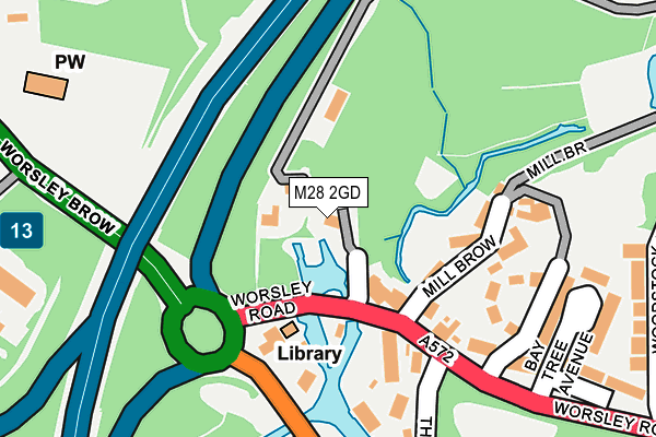
M28 2GD lies on The Delph in Worsley, Manchester. M28 2GD is located in the Worsley & Westwood Park electoral ward, within the metropolitan district of Salford and the English Parliamentary constituency of Worsley and Eccles South. The Sub Integrated Care Board (ICB) Location is NHS Greater Manchester ICB - 01G and the police force is Greater Manchester. This postcode has been in use since May 1994.


GetTheData
Source: OS OpenMap – Local (Ordnance Survey)
Source: OS VectorMap District (Ordnance Survey)
Licence: Open Government Licence (requires attribution)
| Easting | 374834 |
| Northing | 400569 |
| Latitude | 53.501225 |
| Longitude | -2.380859 |
GetTheData
Source: Open Postcode Geo
Licence: Open Government Licence
| Street | The Delph |
| Locality | Worsley |
| Town/City | Manchester |
| Country | England |
| Postcode District | M28 |
| ➜ M28 open data dashboard ➜ See where M28 is on a map ➜ Where is Worsley? | |
GetTheData
Source: Land Registry Price Paid Data
Licence: Open Government Licence
Elevation or altitude of M28 2GD as distance above sea level:
| Metres | Feet | |
|---|---|---|
| Elevation | 30m | 98ft |
Elevation is measured from the approximate centre of the postcode, to the nearest point on an OS contour line from OS Terrain 50, which has contour spacing of ten vertical metres.
➜ How high above sea level am I? Find the elevation of your current position using your device's GPS.
GetTheData
Source: Open Postcode Elevation
Licence: Open Government Licence
| Ward | Worsley & Westwood Park |
| Constituency | Worsley And Eccles South |
GetTheData
Source: ONS Postcode Database
Licence: Open Government Licence
| Worsley Rd/Court House (Worsley Rd) | Worsley | 86m |
| Worsley Rd/Court House (Worsley Rd) | Worsley | 107m |
| Barton Rd/Worsley Court House (Barton Rd) | Worsley | 149m |
| Worsley Brow/M60 (Worsley Brow) | Worsley | 231m |
| Barton Rd/Worsley Court House (Barton Rd) | Worsley | 241m |
| Walkden Station | 2.3km |
| Patricroft Station | 2.4km |
| Moorside Station | 2.6km |
GetTheData
Source: NaPTAN
Licence: Open Government Licence
| Percentage of properties with Next Generation Access | 100.0% |
| Percentage of properties with Superfast Broadband | 100.0% |
| Percentage of properties with Ultrafast Broadband | 100.0% |
| Percentage of properties with Full Fibre Broadband | 100.0% |
Superfast Broadband is between 30Mbps and 300Mbps
Ultrafast Broadband is > 300Mbps
| Percentage of properties unable to receive 2Mbps | 0.0% |
| Percentage of properties unable to receive 5Mbps | 0.0% |
| Percentage of properties unable to receive 10Mbps | 0.0% |
| Percentage of properties unable to receive 30Mbps | 0.0% |
GetTheData
Source: Ofcom
Licence: Ofcom Terms of Use (requires attribution)
GetTheData
Source: ONS Postcode Database
Licence: Open Government Licence


➜ Get more ratings from the Food Standards Agency
GetTheData
Source: Food Standards Agency
Licence: FSA terms & conditions
| Last Collection | |||
|---|---|---|---|
| Location | Mon-Fri | Sat | Distance |
| Mill Brow / Worsley Road | 17:30 | 12:00 | 88m |
| Ellesmere Road P.o. | 17:30 | 12:00 | 292m |
| The Station | 17:30 | 12:00 | 892m |
GetTheData
Source: Dracos
Licence: Creative Commons Attribution-ShareAlike
| Facility | Distance |
|---|---|
| Bridgewater School Worsley Road, Worsley, Manchester Sports Hall, Grass Pitches, Artificial Grass Pitch | 625m |
| Afc Monton New Alder Park, Off Worsley Road, Winton, Manchester Grass Pitches | 775m |
| Winton Cricket Club Alder Forest Avenue, Winton, Salford Grass Pitches | 884m |
GetTheData
Source: Active Places
Licence: Open Government Licence
| School | Phase of Education | Distance |
|---|---|---|
| St Mark's CofE Primary School Aviary Road, Walkden, Worsley, Manchester, M28 2WF | Primary | 374m |
| Bridgewater School Drywood Hall, Worsley Road, Worsley, Manchester, M28 2WQ | Not applicable | 625m |
| Alder Brook Primary Partnership Centre Walnut Road, Winton, Salford, M30 8LE | Not applicable | 903m |
GetTheData
Source: Edubase
Licence: Open Government Licence
The below table lists the International Territorial Level (ITL) codes (formerly Nomenclature of Territorial Units for Statistics (NUTS) codes) and Local Administrative Units (LAU) codes for M28 2GD:
| ITL 1 Code | Name |
|---|---|
| TLD | North West (England) |
| ITL 2 Code | Name |
| TLD3 | Greater Manchester |
| ITL 3 Code | Name |
| TLD34 | Greater Manchester South West |
| LAU 1 Code | Name |
| E08000006 | Salford |
GetTheData
Source: ONS Postcode Directory
Licence: Open Government Licence
The below table lists the Census Output Area (OA), Lower Layer Super Output Area (LSOA), and Middle Layer Super Output Area (MSOA) for M28 2GD:
| Code | Name | |
|---|---|---|
| OA | E00029069 | |
| LSOA | E01005738 | Salford 014C |
| MSOA | E02001170 | Salford 014 |
GetTheData
Source: ONS Postcode Directory
Licence: Open Government Licence
| M28 2NN | Worsley Road | 119m |
| M28 2NL | Worsley Road | 122m |
| M28 2WL | Mill Brow | 122m |
| M28 2PB | Barton Road | 149m |
| M28 2GE | Waterbridge | 154m |
| M28 2GS | Dukes Wharf | 181m |
| M28 2NW | Bay Tree Avenue | 215m |
| M28 2GR | Greenside | 260m |
| M28 2NP | Woodstock Drive | 272m |
| M28 2PD | Barton Road | 282m |
GetTheData
Source: Open Postcode Geo; Land Registry Price Paid Data
Licence: Open Government Licence