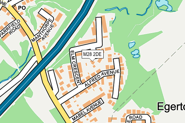
M28 2DE lies on Litchfield Grove in Worsley, Manchester. M28 2DE is located in the Boothstown & Ellenbrook electoral ward, within the metropolitan district of Salford and the English Parliamentary constituency of Worsley and Eccles South. The Sub Integrated Care Board (ICB) Location is NHS Greater Manchester ICB - 01G and the police force is Greater Manchester. This postcode has been in use since May 1994.


GetTheData
Source: OS OpenMap – Local (Ordnance Survey)
Source: OS VectorMap District (Ordnance Survey)
Licence: Open Government Licence (requires attribution)
| Easting | 375480 |
| Northing | 401371 |
| Latitude | 53.508448 |
| Longitude | -2.371185 |
GetTheData
Source: Open Postcode Geo
Licence: Open Government Licence
| Street | Litchfield Grove |
| Locality | Worsley |
| Town/City | Manchester |
| Country | England |
| Postcode District | M28 |
| ➜ M28 open data dashboard ➜ See where M28 is on a map ➜ Where is Worsley? | |
GetTheData
Source: Land Registry Price Paid Data
Licence: Open Government Licence
Elevation or altitude of M28 2DE as distance above sea level:
| Metres | Feet | |
|---|---|---|
| Elevation | 60m | 197ft |
Elevation is measured from the approximate centre of the postcode, to the nearest point on an OS contour line from OS Terrain 50, which has contour spacing of ten vertical metres.
➜ How high above sea level am I? Find the elevation of your current position using your device's GPS.
GetTheData
Source: Open Postcode Elevation
Licence: Open Government Licence
| Ward | Boothstown & Ellenbrook |
| Constituency | Worsley And Eccles South |
GetTheData
Source: ONS Postcode Database
Licence: Open Government Licence
| Greenleach Ln/Mabel Ave (Greenleach Ln) | Broadoak Park | 186m |
| Greenleach Lnmabel Ave (Greenleach Lae) | Broadoak Park | 214m |
| Greenleach Ln/Post Office (Greenleach Ln) | Roe Green | 364m |
| Greenleach Ln/Post Office (Greenleach Ln) | Roe Green | 374m |
| Greenleach Ln/Broad Oak Rd (Greenleach Ln) | Broadoak Park | 416m |
| Moorside Station | 1.6km |
| Walkden Station | 2.1km |
| Swinton (Manchester) Station | 2.3km |
GetTheData
Source: NaPTAN
Licence: Open Government Licence
| Percentage of properties with Next Generation Access | 100.0% |
| Percentage of properties with Superfast Broadband | 100.0% |
| Percentage of properties with Ultrafast Broadband | 100.0% |
| Percentage of properties with Full Fibre Broadband | 100.0% |
Superfast Broadband is between 30Mbps and 300Mbps
Ultrafast Broadband is > 300Mbps
| Percentage of properties unable to receive 2Mbps | 0.0% |
| Percentage of properties unable to receive 5Mbps | 0.0% |
| Percentage of properties unable to receive 10Mbps | 0.0% |
| Percentage of properties unable to receive 30Mbps | 0.0% |
GetTheData
Source: Ofcom
Licence: Ofcom Terms of Use (requires attribution)
GetTheData
Source: ONS Postcode Database
Licence: Open Government Licence


➜ Get more ratings from the Food Standards Agency
GetTheData
Source: Food Standards Agency
Licence: FSA terms & conditions
| Last Collection | |||
|---|---|---|---|
| Location | Mon-Fri | Sat | Distance |
| Roe Green P.o. | 17:30 | 12:00 | 301m |
| Broad Oak Road | 17:30 | 12:00 | 465m |
| The Station | 17:30 | 12:00 | 652m |
GetTheData
Source: Dracos
Licence: Creative Commons Attribution-ShareAlike
| Facility | Distance |
|---|---|
| Roe Green Cricket Club & Recreation Greenleach Lane, Roe Green, Worsley, Manchester Grass Pitches | 660m |
| Roe Green Tennis Club Beesley Green, Worsley Outdoor Tennis Courts | 675m |
| Beesley Green Community Centre Beesley Green, Worsley, Manchester Sports Hall | 684m |
GetTheData
Source: Active Places
Licence: Open Government Licence
| School | Phase of Education | Distance |
|---|---|---|
| Bridgewater School Drywood Hall, Worsley Road, Worsley, Manchester, M28 2WQ | Not applicable | 814m |
| St Mark's CofE Primary School Aviary Road, Walkden, Worsley, Manchester, M28 2WF | Primary | 887m |
| Broadoak Primary School Fairmount Road, Swinton, Manchester, M27 0EP | Primary | 958m |
GetTheData
Source: Edubase
Licence: Open Government Licence
The below table lists the International Territorial Level (ITL) codes (formerly Nomenclature of Territorial Units for Statistics (NUTS) codes) and Local Administrative Units (LAU) codes for M28 2DE:
| ITL 1 Code | Name |
|---|---|
| TLD | North West (England) |
| ITL 2 Code | Name |
| TLD3 | Greater Manchester |
| ITL 3 Code | Name |
| TLD34 | Greater Manchester South West |
| LAU 1 Code | Name |
| E08000006 | Salford |
GetTheData
Source: ONS Postcode Directory
Licence: Open Government Licence
The below table lists the Census Output Area (OA), Lower Layer Super Output Area (LSOA), and Middle Layer Super Output Area (MSOA) for M28 2DE:
| Code | Name | |
|---|---|---|
| OA | E00029083 | |
| LSOA | E01005741 | Salford 014E |
| MSOA | E02001170 | Salford 014 |
GetTheData
Source: ONS Postcode Directory
Licence: Open Government Licence
| M28 2DA | Hawthorne Drive | 34m |
| M28 2TX | Alfred Avenue | 65m |
| M28 2DD | Elm Crescent | 82m |
| M28 2DB | Sandersons Close | 123m |
| M28 2TT | Mabel Avenue | 131m |
| M28 2TU | Greenleach Lane | 140m |
| M28 2TZ | Greenleach Lane | 164m |
| M28 2AZ | Manthorpe Avenue | 173m |
| M28 2TY | Greenleach Lane | 241m |
| M28 2RW | Mulgrave Road | 271m |
GetTheData
Source: Open Postcode Geo; Land Registry Price Paid Data
Licence: Open Government Licence