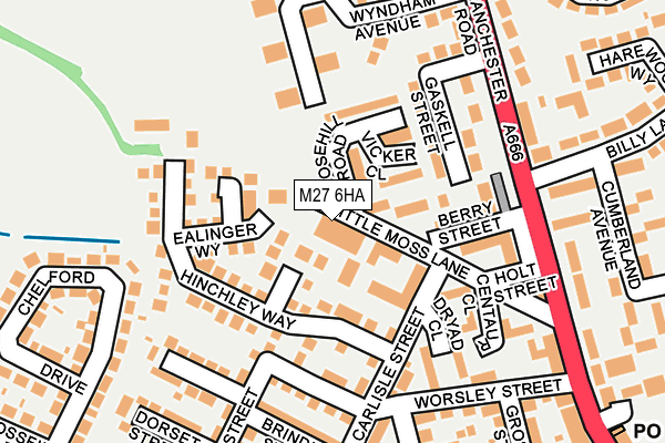
M27 6HA is located in the Swinton & Wardley electoral ward, within the metropolitan district of Salford and the English Parliamentary constituency of Salford and Eccles. The Sub Integrated Care Board (ICB) Location is NHS Greater Manchester ICB - 01G and the police force is Greater Manchester. This postcode has been in use since October 2019.


GetTheData
Source: OS OpenMap – Local (Ordnance Survey)
Source: OS VectorMap District (Ordnance Survey)
Licence: Open Government Licence (requires attribution)
| Easting | 377714 |
| Northing | 402804 |
| Latitude | 53.521445 |
| Longitude | -2.337602 |
GetTheData
Source: Open Postcode Geo
Licence: Open Government Licence
| Country | England |
| Postcode District | M27 |
| ➜ M27 open data dashboard ➜ See where M27 is on a map ➜ Where is Clifton? | |
GetTheData
Source: Land Registry Price Paid Data
Licence: Open Government Licence
Elevation or altitude of M27 6HA as distance above sea level:
| Metres | Feet | |
|---|---|---|
| Elevation | 80m | 262ft |
Elevation is measured from the approximate centre of the postcode, to the nearest point on an OS contour line from OS Terrain 50, which has contour spacing of ten vertical metres.
➜ How high above sea level am I? Find the elevation of your current position using your device's GPS.
GetTheData
Source: Open Postcode Elevation
Licence: Open Government Licence
| Ward | Swinton & Wardley |
| Constituency | Salford And Eccles |
GetTheData
Source: ONS Postcode Database
Licence: Open Government Licence
| Manchester Rd/Billy Ln (Manchester Rd) | Clifton | 172m |
| Manchester Rd/Billy Ln (Manchester Rd) | Clifton | 189m |
| Billy Ln/Cumberland Ave (Billy Ln) | Clifton | 218m |
| Billy Ln/Cumberland Ave (Billy Ln) | Clifton | 276m |
| Mossfield Rd/Carlisle St (Mossfield Rd) | Pendlebury | 282m |
| Swinton (Manchester) Station | 0.7km |
| Moorside Station | 1.1km |
| Clifton (Manchester) Station | 1.5km |
GetTheData
Source: NaPTAN
Licence: Open Government Licence
GetTheData
Source: ONS Postcode Database
Licence: Open Government Licence


➜ Get more ratings from the Food Standards Agency
GetTheData
Source: Food Standards Agency
Licence: FSA terms & conditions
| Last Collection | |||
|---|---|---|---|
| Location | Mon-Fri | Sat | Distance |
| Swinton P.o. | 18:15 | 12:00 | 1,092m |
| Heywood Street | 17:30 | 12:00 | 1,288m |
| Market Place | 17:30 | 12:00 | 1,526m |
GetTheData
Source: Dracos
Licence: Creative Commons Attribution-ShareAlike
| Facility | Distance |
|---|---|
| Mossfield Primary School Mossfield Road, Pendlebury, Swinton, Manchester Grass Pitches | 351m |
| Muscle & Fitness Gym Station Road, Swinton Health and Fitness Gym | 389m |
| St Marks Rc Primary School Queensway, Clifton, Swinton, Manchester Grass Pitches | 567m |
GetTheData
Source: Active Places
Licence: Open Government Licence
| School | Phase of Education | Distance |
|---|---|---|
| Clifton Primary School Wroe Street, Clifton, Swinton, Manchester, M27 6PF | Primary | 289m |
| Mossfield Primary School Mossfield Road, Swinton, Mossfield Primary School, Manchester, M27 6EH | Primary | 340m |
| St Mark's RC Primary School Queensway, Clifton, Swinton, Manchester, M27 8QE | Primary | 546m |
GetTheData
Source: Edubase
Licence: Open Government Licence
The below table lists the International Territorial Level (ITL) codes (formerly Nomenclature of Territorial Units for Statistics (NUTS) codes) and Local Administrative Units (LAU) codes for M27 6HA:
| ITL 1 Code | Name |
|---|---|
| TLD | North West (England) |
| ITL 2 Code | Name |
| TLD3 | Greater Manchester |
| ITL 3 Code | Name |
| TLD34 | Greater Manchester South West |
| LAU 1 Code | Name |
| E08000006 | Salford |
GetTheData
Source: ONS Postcode Directory
Licence: Open Government Licence
The below table lists the Census Output Area (OA), Lower Layer Super Output Area (LSOA), and Middle Layer Super Output Area (MSOA) for M27 6HA:
| Code | Name | |
|---|---|---|
| OA | E00028795 | |
| LSOA | E01005688 | Salford 006B |
| MSOA | E02001162 | Salford 006 |
GetTheData
Source: ONS Postcode Directory
Licence: Open Government Licence
| M27 6GE | Rosehill Mews | 38m |
| M27 6HF | Torside Way | 42m |
| M27 6PX | Little Moss Lane | 50m |
| M27 6QE | Vicker Close | 73m |
| M27 6HJ | Chendre Close | 79m |
| M27 6GB | Berry Street | 83m |
| M27 6GL | Little Moss Lane | 93m |
| M27 6HG | Ealinger Way | 102m |
| M27 6GD | Newtown Close | 104m |
| M27 6QD | Rosehill Road | 105m |
GetTheData
Source: Open Postcode Geo; Land Registry Price Paid Data
Licence: Open Government Licence