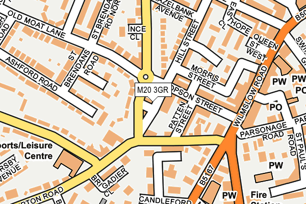
M20 3GR is located in the Old Moat electoral ward, within the metropolitan district of Manchester and the English Parliamentary constituency of Manchester, Withington. The Sub Integrated Care Board (ICB) Location is NHS Greater Manchester ICB - 14L and the police force is Greater Manchester. This postcode has been in use since May 1994.


GetTheData
Source: OS OpenMap – Local (Ordnance Survey)
Source: OS VectorMap District (Ordnance Survey)
Licence: Open Government Licence (requires attribution)
| Easting | 384724 |
| Northing | 393008 |
| Latitude | 53.433646 |
| Longitude | -2.231394 |
GetTheData
Source: Open Postcode Geo
Licence: Open Government Licence
| Country | England |
| Postcode District | M20 |
| ➜ M20 open data dashboard ➜ See where M20 is on a map ➜ Where is Manchester? | |
GetTheData
Source: Land Registry Price Paid Data
Licence: Open Government Licence
Elevation or altitude of M20 3GR as distance above sea level:
| Metres | Feet | |
|---|---|---|
| Elevation | 30m | 98ft |
Elevation is measured from the approximate centre of the postcode, to the nearest point on an OS contour line from OS Terrain 50, which has contour spacing of ten vertical metres.
➜ How high above sea level am I? Find the elevation of your current position using your device's GPS.
GetTheData
Source: Open Postcode Elevation
Licence: Open Government Licence
| Ward | Old Moat |
| Constituency | Manchester, Withington |
GetTheData
Source: ONS Postcode Database
Licence: Open Government Licence
| Copson St/Patten St (Copson St) | Withington | 81m |
| Yew Tree Rd/Copson St (Yew Tree Rd) | Withington | 111m |
| Palatine Rd/Wilmslow Rd (Palatine Rd) | Withington | 155m |
| Yew Tree Rd/Copson St (Yew Tree Rd) | Withington | 161m |
| Burton Rd/Whitchurch Rd (Burton Rd) | Withington | 175m |
| Burton Road (Manchester Metrolink) (Burton Road) | West Didsbury | 792m |
| West Didsbury (Manchester Metrolink) (Lapwing Lane) | West Didsbury | 1,066m |
| Withington (Manchester Metrolink) (Princess Road) | Withington | 1,200m |
| Mauldeth Road Station | 1.5km |
| Burnage Station | 1.7km |
| East Didsbury Station | 2.8km |
GetTheData
Source: NaPTAN
Licence: Open Government Licence
| Percentage of properties with Next Generation Access | 100.0% |
| Percentage of properties with Superfast Broadband | 100.0% |
| Percentage of properties with Ultrafast Broadband | 100.0% |
| Percentage of properties with Full Fibre Broadband | 0.0% |
Superfast Broadband is between 30Mbps and 300Mbps
Ultrafast Broadband is > 300Mbps
| Percentage of properties unable to receive 2Mbps | 0.0% |
| Percentage of properties unable to receive 5Mbps | 0.0% |
| Percentage of properties unable to receive 10Mbps | 0.0% |
| Percentage of properties unable to receive 30Mbps | 0.0% |
GetTheData
Source: Ofcom
Licence: Ofcom Terms of Use (requires attribution)
GetTheData
Source: ONS Postcode Database
Licence: Open Government Licence


➜ Get more ratings from the Food Standards Agency
GetTheData
Source: Food Standards Agency
Licence: FSA terms & conditions
| Last Collection | |||
|---|---|---|---|
| Location | Mon-Fri | Sat | Distance |
| White Lion | 17:30 | 12:00 | 136m |
| Off 54 Old Moat Lane | 17:30 | 12:00 | 174m |
| Withington P.o. | 17:30 | 12:00 | 277m |
GetTheData
Source: Dracos
Licence: Creative Commons Attribution-ShareAlike
| Facility | Distance |
|---|---|
| Withington Baths & Leisure Centre Burton Road, Manchester Swimming Pool, Health and Fitness Gym, Studio | 175m |
| Withington Girls School Wellington Road, Fallowfield, Manchester Sports Hall, Grass Pitches, Artificial Grass Pitch, Health and Fitness Gym, Studio | 700m |
| Fallowfields Lawn Tennis Club Wellington Road, Fallowfield, Manchester Outdoor Tennis Courts | 753m |
GetTheData
Source: Active Places
Licence: Open Government Licence
| School | Phase of Education | Distance |
|---|---|---|
| Bridgelea Pupil Referral Unit Bridgelea Road, Withington, Manchester, M20 3FB | Not applicable | 114m |
| St Paul's CofE Primary School St Paul's Road, Withington, Manchester, M20 4PG | Primary | 275m |
| Old Moat Primary School Old Moat Lane, Withington, Manchester, M20 3FN | Primary | 416m |
GetTheData
Source: Edubase
Licence: Open Government Licence
The below table lists the International Territorial Level (ITL) codes (formerly Nomenclature of Territorial Units for Statistics (NUTS) codes) and Local Administrative Units (LAU) codes for M20 3GR:
| ITL 1 Code | Name |
|---|---|
| TLD | North West (England) |
| ITL 2 Code | Name |
| TLD3 | Greater Manchester |
| ITL 3 Code | Name |
| TLD33 | Manchester |
| LAU 1 Code | Name |
| E08000003 | Manchester |
GetTheData
Source: ONS Postcode Directory
Licence: Open Government Licence
The below table lists the Census Output Area (OA), Lower Layer Super Output Area (LSOA), and Middle Layer Super Output Area (MSOA) for M20 3GR:
| Code | Name | |
|---|---|---|
| OA | E00026748 | |
| LSOA | E01005274 | Manchester 038A |
| MSOA | E02001082 | Manchester 038 |
GetTheData
Source: ONS Postcode Directory
Licence: Open Government Licence
| M20 3FD | Hopelea Street | 8m |
| M20 3ED | Burton Road | 58m |
| M20 3GD | Burton Road | 77m |
| M20 3EE | Old Moat Lane | 83m |
| M20 3BJ | Bridgelea Road | 84m |
| M20 3HD | Patten Street | 84m |
| M20 3HL | Hill Street | 102m |
| M20 3FB | Bridgelea Road | 105m |
| M20 3FF | Bradshaw Avenue | 110m |
| M20 3GG | Chapel Terrace | 110m |
GetTheData
Source: Open Postcode Geo; Land Registry Price Paid Data
Licence: Open Government Licence