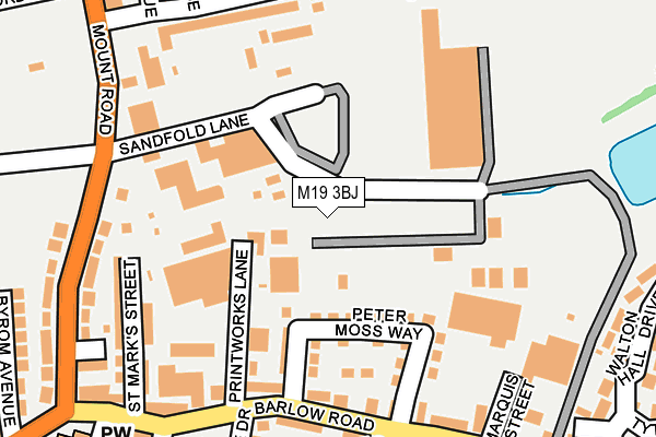
M19 3BJ lies on Sandfold Lane in Manchester. M19 3BJ is located in the Levenshulme electoral ward, within the metropolitan district of Manchester and the English Parliamentary constituency of Manchester, Gorton. The Sub Integrated Care Board (ICB) Location is NHS Greater Manchester ICB - 14L and the police force is Greater Manchester. This postcode has been in use since January 1993.


GetTheData
Source: OS OpenMap – Local (Ordnance Survey)
Source: OS VectorMap District (Ordnance Survey)
Licence: Open Government Licence (requires attribution)
| Easting | 388392 |
| Northing | 394544 |
| Latitude | 53.447530 |
| Longitude | -2.176243 |
GetTheData
Source: Open Postcode Geo
Licence: Open Government Licence
| Street | Sandfold Lane |
| Town/City | Manchester |
| Country | England |
| Postcode District | M19 |
| ➜ M19 open data dashboard ➜ See where M19 is on a map ➜ Where is Manchester? | |
GetTheData
Source: Land Registry Price Paid Data
Licence: Open Government Licence
Elevation or altitude of M19 3BJ as distance above sea level:
| Metres | Feet | |
|---|---|---|
| Elevation | 60m | 197ft |
Elevation is measured from the approximate centre of the postcode, to the nearest point on an OS contour line from OS Terrain 50, which has contour spacing of ten vertical metres.
➜ How high above sea level am I? Find the elevation of your current position using your device's GPS.
GetTheData
Source: Open Postcode Elevation
Licence: Open Government Licence
| Ward | Levenshulme |
| Constituency | Manchester, Gorton |
GetTheData
Source: ONS Postcode Database
Licence: Open Government Licence
RYECROFT COTTAGE, SANDFOLD LANE, MANCHESTER, M19 3BJ 2001 2 AUG £85,000 |
GetTheData
Source: HM Land Registry Price Paid Data
Licence: Contains HM Land Registry data © Crown copyright and database right 2024. This data is licensed under the Open Government Licence v3.0.
| Barlow Rd/Printworks Ln (Barlow Rd) | Levenshulme | 176m |
| Barlow Rd/Printworks Ln (Barlow Rd) | Levenshulme | 189m |
| Barlow Rd/Southwold Cl (Barlow Rd) | Levenshulme | 210m |
| Mount Rd/Manor Rd (Mount Rd) | Levenshulme | 211m |
| Barlow Rd/Southwold Cl (Barlow Rd) | Levenshulme | 218m |
| Ryder Brow Station | 1km |
| Levenshulme Station | 1.2km |
| Reddish North Station | 1.3km |
GetTheData
Source: NaPTAN
Licence: Open Government Licence
| Median download speed | 73.2Mbps |
| Average download speed | 58.9Mbps |
| Maximum download speed | 80.00Mbps |
| Median upload speed | 13.9Mbps |
| Average upload speed | 12.9Mbps |
| Maximum upload speed | 20.00Mbps |
GetTheData
Source: Ofcom
Licence: Ofcom Terms of Use (requires attribution)
GetTheData
Source: ONS Postcode Database
Licence: Open Government Licence


➜ Get more ratings from the Food Standards Agency
GetTheData
Source: Food Standards Agency
Licence: FSA terms & conditions
| Last Collection | |||
|---|---|---|---|
| Location | Mon-Fri | Sat | Distance |
| Marquis Street | 17:30 | 12:00 | 244m |
| Barlow Road P.o. | 17:30 | 12:00 | 329m |
| 49 Hornbeam Road | 17:30 | 12:00 | 599m |
GetTheData
Source: Dracos
Licence: Creative Commons Attribution-ShareAlike
| Facility | Distance |
|---|---|
| Greater Manchester Transport Club (Closed) Mount Road, Manchester Sports Hall | 245m |
| East Levenshulme Cricket Club Elsa Road, Elsa Road, Manchester Grass Pitches | 274m |
| Cedar Mount Academy Wembley Road, Manchester Sports Hall, Artificial Grass Pitch, Grass Pitches | 368m |
GetTheData
Source: Active Places
Licence: Open Government Licence
| School | Phase of Education | Distance |
|---|---|---|
| Melland High School Gorton Education Village, 50 Wembley Road, Gorton, M18 7DT | Not applicable | 339m |
| Cedar Mount Academy Gorton Education Village, 50 Wembley Road, Gorton, M18 7DT | Secondary | 339m |
| Rushbrook Primary Academy Shillingford Road, Gorton, Manchester, M18 7TN | Primary | 491m |
GetTheData
Source: Edubase
Licence: Open Government Licence
The below table lists the International Territorial Level (ITL) codes (formerly Nomenclature of Territorial Units for Statistics (NUTS) codes) and Local Administrative Units (LAU) codes for M19 3BJ:
| ITL 1 Code | Name |
|---|---|
| TLD | North West (England) |
| ITL 2 Code | Name |
| TLD3 | Greater Manchester |
| ITL 3 Code | Name |
| TLD33 | Manchester |
| LAU 1 Code | Name |
| E08000003 | Manchester |
GetTheData
Source: ONS Postcode Directory
Licence: Open Government Licence
The below table lists the Census Output Area (OA), Lower Layer Super Output Area (LSOA), and Middle Layer Super Output Area (MSOA) for M19 3BJ:
| Code | Name | |
|---|---|---|
| OA | E00026313 | |
| LSOA | E01005200 | Manchester 027C |
| MSOA | E02001071 | Manchester 027 |
GetTheData
Source: ONS Postcode Directory
Licence: Open Government Licence
| M19 3JS | Peter Moss Way | 121m |
| M19 3JR | Greystoke Avenue | 125m |
| M19 3JF | Barlow Road | 177m |
| M19 3HB | Gytes Lane | 188m |
| M19 3GW | Bratton Drive | 200m |
| M19 3JB | Barlow Road | 201m |
| M19 3HG | St Marks Street | 217m |
| M19 3JZ | Marquis Street | 224m |
| M19 3HW | Mount Road | 225m |
| M19 3HQ | Barlow Road | 235m |
GetTheData
Source: Open Postcode Geo; Land Registry Price Paid Data
Licence: Open Government Licence