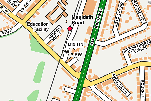
M19 1TN is located in the Burnage electoral ward, within the metropolitan district of Manchester and the English Parliamentary constituency of Manchester, Withington. The Sub Integrated Care Board (ICB) Location is NHS Greater Manchester ICB - 14L and the police force is Greater Manchester. This postcode has been in use since September 2007.


GetTheData
Source: OS OpenMap – Local (Ordnance Survey)
Source: OS VectorMap District (Ordnance Survey)
Licence: Open Government Licence (requires attribution)
| Easting | 386250 |
| Northing | 392952 |
| Latitude | 53.433185 |
| Longitude | -2.208422 |
GetTheData
Source: Open Postcode Geo
Licence: Open Government Licence
| Country | England |
| Postcode District | M19 |
| ➜ M19 open data dashboard ➜ See where M19 is on a map ➜ Where is Manchester? | |
GetTheData
Source: Land Registry Price Paid Data
Licence: Open Government Licence
Elevation or altitude of M19 1TN as distance above sea level:
| Metres | Feet | |
|---|---|---|
| Elevation | 50m | 164ft |
Elevation is measured from the approximate centre of the postcode, to the nearest point on an OS contour line from OS Terrain 50, which has contour spacing of ten vertical metres.
➜ How high above sea level am I? Find the elevation of your current position using your device's GPS.
GetTheData
Source: Open Postcode Elevation
Licence: Open Government Licence
| Ward | Burnage |
| Constituency | Manchester, Withington |
GetTheData
Source: ONS Postcode Database
Licence: Open Government Licence
| Kingsway/Mauldeth Rd (Kingsway) | Burnage | 40m |
| Mauldeth Rd/Rail Stn (Mauldeth Rd) | Burnage | 83m |
| Mauldeth Rd/Primary Sch (Mauldeth Rd) | Burnage | 143m |
| Mauldeth Rd/Kingsway (Mauldeth Rd) | Burnage | 150m |
| Kingsway/Mauldeth Rd (Kingsway) | Burnage | 159m |
| Mauldeth Road Station | 0.1km |
| Burnage Station | 1.4km |
| Levenshulme Station | 1.6km |
GetTheData
Source: NaPTAN
Licence: Open Government Licence
GetTheData
Source: ONS Postcode Database
Licence: Open Government Licence


➜ Get more ratings from the Food Standards Agency
GetTheData
Source: Food Standards Agency
Licence: FSA terms & conditions
| Last Collection | |||
|---|---|---|---|
| Location | Mon-Fri | Sat | Distance |
| 192 Mauldeth Road | 17:30 | 12:00 | 179m |
| Ladybarn P.o. | 17:30 | 12:00 | 432m |
| Garden Village | 17:30 | 12:00 | 517m |
GetTheData
Source: Dracos
Licence: Creative Commons Attribution-ShareAlike
| Facility | Distance |
|---|---|
| Ladybarn Park Parsonage Road, Manchester Outdoor Tennis Courts, Grass Pitches | 300m |
| St Bernards Greenend Primary School Burnage Lane, Manchester Sports Hall | 584m |
| Burnage Academy For Boys Burnage Lane, Manchester Sports Hall, Grass Pitches, Health and Fitness Gym, Artificial Grass Pitch | 588m |
GetTheData
Source: Active Places
Licence: Open Government Licence
| School | Phase of Education | Distance |
|---|---|---|
| Mauldeth Road Primary School Mauldeth Road, Withington, Manchester, M14 6SG | Primary | 163m |
| Ladybarn Primary School Briarfield Road, Withington, Manchester, M20 4SR | Primary | 440m |
| Green End Primary School Burnage Lane, Burnage, Manchester, M19 1DR | Primary | 554m |
GetTheData
Source: Edubase
Licence: Open Government Licence
The below table lists the International Territorial Level (ITL) codes (formerly Nomenclature of Territorial Units for Statistics (NUTS) codes) and Local Administrative Units (LAU) codes for M19 1TN:
| ITL 1 Code | Name |
|---|---|
| TLD | North West (England) |
| ITL 2 Code | Name |
| TLD3 | Greater Manchester |
| ITL 3 Code | Name |
| TLD33 | Manchester |
| LAU 1 Code | Name |
| E08000003 | Manchester |
GetTheData
Source: ONS Postcode Directory
Licence: Open Government Licence
The below table lists the Census Output Area (OA), Lower Layer Super Output Area (LSOA), and Middle Layer Super Output Area (MSOA) for M19 1TN:
| Code | Name | |
|---|---|---|
| OA | E00025931 | |
| LSOA | E01005118 | Manchester 034A |
| MSOA | E02001078 | Manchester 034 |
GetTheData
Source: ONS Postcode Directory
Licence: Open Government Licence
| M19 1BA | Mauldeth Road | 47m |
| M19 2NB | Kingsway | 91m |
| M19 1BB | Kingsway | 92m |
| M14 6SE | Aubrey Road | 94m |
| M19 1BF | Mauldeth Road | 95m |
| M14 6SG | Mauldeth Road | 110m |
| M19 1AL | Kingsway | 110m |
| M19 2WA | Burnside Drive | 149m |
| M19 2WB | Kingsway | 174m |
| M19 1AJ | Mauldeth Road | 177m |
GetTheData
Source: Open Postcode Geo; Land Registry Price Paid Data
Licence: Open Government Licence