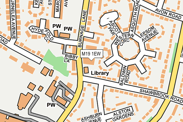
M19 1EW is located in the Burnage electoral ward, within the metropolitan district of Manchester and the English Parliamentary constituency of Manchester, Withington. The Sub Integrated Care Board (ICB) Location is NHS Greater Manchester ICB - 14L and the police force is Greater Manchester. This postcode has been in use since January 1980.


GetTheData
Source: OS OpenMap – Local (Ordnance Survey)
Source: OS VectorMap District (Ordnance Survey)
Licence: Open Government Licence (requires attribution)
| Easting | 386780 |
| Northing | 392618 |
| Latitude | 53.430180 |
| Longitude | -2.200433 |
GetTheData
Source: Open Postcode Geo
Licence: Open Government Licence
| Country | England |
| Postcode District | M19 |
| ➜ M19 open data dashboard ➜ See where M19 is on a map ➜ Where is Manchester? | |
GetTheData
Source: Land Registry Price Paid Data
Licence: Open Government Licence
Elevation or altitude of M19 1EW as distance above sea level:
| Metres | Feet | |
|---|---|---|
| Elevation | 50m | 164ft |
Elevation is measured from the approximate centre of the postcode, to the nearest point on an OS contour line from OS Terrain 50, which has contour spacing of ten vertical metres.
➜ How high above sea level am I? Find the elevation of your current position using your device's GPS.
GetTheData
Source: Open Postcode Elevation
Licence: Open Government Licence
| Ward | Burnage |
| Constituency | Manchester, Withington |
GetTheData
Source: ONS Postcode Database
Licence: Open Government Licence
| May 2022 | Violence and sexual offences | On or near Arbor Drive | 406m |
| December 2021 | Drugs | On or near Chorley Wood Avenue | 62m |
| ➜ Get more crime data in our Crime section | |||
GetTheData
Source: data.police.uk
Licence: Open Government Licence
| Burnage Ln/Farmers Arms (Burnage Ln) | Burnage | 69m |
| Burnage Ln/Farmers Arms (Burnage Ln) | Burnage | 80m |
| Burnage Ln/St Bernard's (Burnage Ln) | Burnage | 125m |
| Burnage Ln/Mauldeth Rd (Burnage Ln) | Burnage | 227m |
| Mauldeth Rd/Burnage Ln (Mauldeth Rd) | Burnage | 264m |
| Mauldeth Road Station | 0.7km |
| Burnage Station | 1.4km |
| Heaton Chapel Station | 1.5km |
GetTheData
Source: NaPTAN
Licence: Open Government Licence
Estimated total energy consumption in M19 1EW by fuel type, 2015.
| Consumption (kWh) | 121,849 |
|---|---|
| Meter count | 10 |
| Mean (kWh/meter) | 12,185 |
| Median (kWh/meter) | 10,573 |
GetTheData
Source: Postcode level gas estimates: 2015 (experimental)
Source: Postcode level electricity estimates: 2015 (experimental)
Licence: Open Government Licence
GetTheData
Source: ONS Postcode Database
Licence: Open Government Licence


➜ Get more ratings from the Food Standards Agency
GetTheData
Source: Food Standards Agency
Licence: FSA terms & conditions
| Last Collection | |||
|---|---|---|---|
| Location | Mon-Fri | Sat | Distance |
| Shawbrook Road | 17:30 | 12:00 | 276m |
| Alwinton Avenue | 16:30 | 11:45 | 280m |
| Market Place | 17:30 | 12:00 | 301m |
GetTheData
Source: Dracos
Licence: Creative Commons Attribution-ShareAlike
| Facility | Distance |
|---|---|
| St Bernards Greenend Primary School Burnage Lane, Manchester Sports Hall | 157m |
| Burnage Academy For Boys Burnage Lane, Manchester Sports Hall, Grass Pitches, Health and Fitness Gym, Artificial Grass Pitch | 340m |
| Heaton Moor Golf Club Mauldeth Road, Stockport Golf | 661m |
GetTheData
Source: Active Places
Licence: Open Government Licence
| School | Phase of Education | Distance |
|---|---|---|
| St Bernard's RC Primary School Manchester Burnage Lane, Manchester, M19 1DR | Primary | 157m |
| Green End Primary School Burnage Lane, Burnage, Manchester, M19 1DR | Primary | 258m |
| Burnage Academy for Boys Burnage Lane, Burnage, Manchester, M19 1ER | Secondary | 416m |
GetTheData
Source: Edubase
Licence: Open Government Licence
The below table lists the International Territorial Level (ITL) codes (formerly Nomenclature of Territorial Units for Statistics (NUTS) codes) and Local Administrative Units (LAU) codes for M19 1EW:
| ITL 1 Code | Name |
|---|---|
| TLD | North West (England) |
| ITL 2 Code | Name |
| TLD3 | Greater Manchester |
| ITL 3 Code | Name |
| TLD33 | Manchester |
| LAU 1 Code | Name |
| E08000003 | Manchester |
GetTheData
Source: ONS Postcode Directory
Licence: Open Government Licence
The below table lists the Census Output Area (OA), Lower Layer Super Output Area (LSOA), and Middle Layer Super Output Area (MSOA) for M19 1EW:
| Code | Name | |
|---|---|---|
| OA | E00025943 | |
| LSOA | E01005122 | Manchester 041C |
| MSOA | E02001085 | Manchester 041 |
GetTheData
Source: ONS Postcode Directory
Licence: Open Government Licence
| M19 1HE | Chorley Wood Avenue | 23m |
| M19 1LZ | Western Circle | 60m |
| M19 1EN | Burnage Lane | 63m |
| M19 1TA | Dahlia Close | 64m |
| M19 1DJ | Shawbrook Road | 67m |
| M19 1GQ | Bibby Lane | 88m |
| M19 1GG | Church Lane | 109m |
| M19 1LY | Baldwin Road | 125m |
| M19 1HH | Western Circle | 128m |
| M19 1FB | Westdean Crescent | 134m |
GetTheData
Source: Open Postcode Geo; Land Registry Price Paid Data
Licence: Open Government Licence