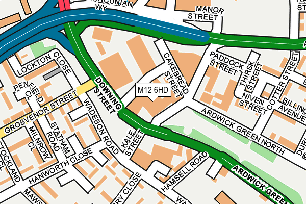
M12 6HD is located in the Ardwick electoral ward, within the metropolitan district of Manchester and the English Parliamentary constituency of Manchester Central. The Sub Integrated Care Board (ICB) Location is NHS Greater Manchester ICB - 14L and the police force is Greater Manchester. This postcode has been in use since January 1980.


GetTheData
Source: OS OpenMap – Local (Ordnance Survey)
Source: OS VectorMap District (Ordnance Survey)
Licence: Open Government Licence (requires attribution)
| Easting | 385008 |
| Northing | 397322 |
| Latitude | 53.472414 |
| Longitude | -2.227328 |
GetTheData
Source: Open Postcode Geo
Licence: Open Government Licence
| Country | England |
| Postcode District | M12 |
| ➜ M12 open data dashboard ➜ See where M12 is on a map ➜ Where is Manchester? | |
GetTheData
Source: Land Registry Price Paid Data
Licence: Open Government Licence
Elevation or altitude of M12 6HD as distance above sea level:
| Metres | Feet | |
|---|---|---|
| Elevation | 40m | 131ft |
Elevation is measured from the approximate centre of the postcode, to the nearest point on an OS contour line from OS Terrain 50, which has contour spacing of ten vertical metres.
➜ How high above sea level am I? Find the elevation of your current position using your device's GPS.
GetTheData
Source: Open Postcode Elevation
Licence: Open Government Licence
| Ward | Ardwick |
| Constituency | Manchester Central |
GetTheData
Source: ONS Postcode Database
Licence: Open Government Licence
| Downing St/Grosvenor St (Downing St) | Ardwick | 76m |
| Ardwick Green Sth/Ardwick Green (Ardwick Grn Sth) | Ardwick | 89m |
| Ardwick Green Sth/Ardwick Green (Ardwick Grn Sth) | Ardwick | 201m |
| London Rd/Travis St (London Road) | Manchester City Centre | 337m |
| Brunswick St/Ardwick Green (Brunswick St) | Ardwick | 364m |
| Piccadilly (Manchester Metrolink) (London Road) | Manchester City Centre | 613m |
| Piccadilly Gardens (Manchester Metrolink) (Portland Street) | Piccadilly Gardens | 1,047m |
| New Islington (Manchester Metrolink) (Pollard Street) | New Islington | 1,085m |
| St Peters Square (Manchester Metrolink) (Peter Street) | Manchester City Centre | 1,230m |
| Market Street (Manchester Metrolink) (Market Street) | Manchester City Centre | 1,317m |
| Manchester Piccadilly Station | 0.6km |
| Ardwick Station | 0.9km |
| Manchester Oxford Road Station | 1km |
GetTheData
Source: NaPTAN
Licence: Open Government Licence
GetTheData
Source: ONS Postcode Database
Licence: Open Government Licence

➜ Get more ratings from the Food Standards Agency
GetTheData
Source: Food Standards Agency
Licence: FSA terms & conditions
| Last Collection | |||
|---|---|---|---|
| Location | Mon-Fri | Sat | Distance |
| St Thomas | 17:30 | 12:00 | 203m |
| Brunswich Street | 17:30 | 12:00 | 366m |
| Fairfield Street/ | 19:00 | 12:00 | 465m |
GetTheData
Source: Dracos
Licence: Creative Commons Attribution-ShareAlike
| Facility | Distance |
|---|---|
| Vital Health & Wellbeing (Manchester Hotel) London Road, Manchester Health and Fitness Gym | 376m |
| Powerleague (Manchester Central) Union Street, Ardwick, Manchester Artificial Grass Pitch | 512m |
| Sugden Sports Centre Grosvenor Street, Manchester Sports Hall, Health and Fitness Gym, Squash Courts, Artificial Grass Pitch, Studio | 578m |
GetTheData
Source: Active Places
Licence: Open Government Licence
| School | Phase of Education | Distance |
|---|---|---|
| Co-Op Academy Medlock Wadeson Road, Chorlton-on-Medlock, Manchester, M13 9UJ | Primary | 259m |
| Sol Christian Academy 115, Fairfield Street, M12 6EL | Not applicable | 594m |
| University of Manchester Oxford Road, Manchester, M13 9PL | Not applicable | 634m |
GetTheData
Source: Edubase
Licence: Open Government Licence
The below table lists the International Territorial Level (ITL) codes (formerly Nomenclature of Territorial Units for Statistics (NUTS) codes) and Local Administrative Units (LAU) codes for M12 6HD:
| ITL 1 Code | Name |
|---|---|
| TLD | North West (England) |
| ITL 2 Code | Name |
| TLD3 | Greater Manchester |
| ITL 3 Code | Name |
| TLD33 | Manchester |
| LAU 1 Code | Name |
| E08000003 | Manchester |
GetTheData
Source: ONS Postcode Directory
Licence: Open Government Licence
The below table lists the Census Output Area (OA), Lower Layer Super Output Area (LSOA), and Middle Layer Super Output Area (MSOA) for M12 6HD:
| Code | Name | |
|---|---|---|
| OA | E00025617 | |
| LSOA | E01005065 | Manchester 018D |
| MSOA | E02001062 | Manchester 018 |
GetTheData
Source: ONS Postcode Directory
Licence: Open Government Licence
| M1 7JE | Downing Street | 38m |
| M13 9XE | Ardwick Green South | 112m |
| M12 6DL | Ardwick Green North | 113m |
| M12 6HE | Manor Street | 116m |
| M13 9UG | Wadeson Road | 149m |
| M13 9UQ | Brownslow Walk | 158m |
| M13 9XB | Harehill Close | 161m |
| M13 9UR | Henshaw Walk | 186m |
| M13 9WB | Bankmill Close | 208m |
| M13 9UW | Arley Moss Walk | 209m |
GetTheData
Source: Open Postcode Geo; Land Registry Price Paid Data
Licence: Open Government Licence