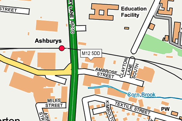
M12 5DD is located in the Gorton & Abbey Hey electoral ward, within the metropolitan district of Manchester and the English Parliamentary constituency of Manchester, Gorton. The Sub Integrated Care Board (ICB) Location is NHS Greater Manchester ICB - 14L and the police force is Greater Manchester. This postcode has been in use since September 1991.


GetTheData
Source: OS OpenMap – Local (Ordnance Survey)
Source: OS VectorMap District (Ordnance Survey)
Licence: Open Government Licence (requires attribution)
| Easting | 387263 |
| Northing | 397206 |
| Latitude | 53.471447 |
| Longitude | -2.193349 |
GetTheData
Source: Open Postcode Geo
Licence: Open Government Licence
| Country | England |
| Postcode District | M12 |
| ➜ M12 open data dashboard ➜ See where M12 is on a map ➜ Where is Manchester? | |
GetTheData
Source: Land Registry Price Paid Data
Licence: Open Government Licence
Elevation or altitude of M12 5DD as distance above sea level:
| Metres | Feet | |
|---|---|---|
| Elevation | 60m | 197ft |
Elevation is measured from the approximate centre of the postcode, to the nearest point on an OS contour line from OS Terrain 50, which has contour spacing of ten vertical metres.
➜ How high above sea level am I? Find the elevation of your current position using your device's GPS.
GetTheData
Source: Open Postcode Elevation
Licence: Open Government Licence
| Ward | Gorton & Abbey Hey |
| Constituency | Manchester, Gorton |
GetTheData
Source: ONS Postcode Database
Licence: Open Government Licence
| Pottery Ln/Ashburys Stn (Pottery Ln) | Ashburys | 70m |
| Pottery Ln/Gorton Rd (Pottery Ln) | Ashburys | 93m |
| Pottery Ln/Ashton Old Rd (Pottery Ln) | Beswick | 250m |
| Wenlock Way/Pottery Ln (Wenlock Way) | West Gorton | 251m |
| Wenlock Way/Clowes St (Wenlock Way) | West Gorton | 308m |
| Velopark (Manchester Metrolink) (Ashton New Road) | Sportcity | 1,205m |
| Clayton Hall (Manchester Metrolink) (Ashton New Road) | Clayton | 1,465m |
| Holt Town (Manchester Metrolink) (Holt Town) | Holt Town | 1,811m |
| Ashburys Station | 0.1km |
| Belle Vue Station | 1.3km |
| Ardwick Station | 1.4km |
GetTheData
Source: NaPTAN
Licence: Open Government Licence
GetTheData
Source: ONS Postcode Database
Licence: Open Government Licence


➜ Get more ratings from the Food Standards Agency
GetTheData
Source: Food Standards Agency
Licence: FSA terms & conditions
| Last Collection | |||
|---|---|---|---|
| Location | Mon-Fri | Sat | Distance |
| Gorton Brook | 17:30 | 12:00 | 350m |
| Openshaw P.o. | 17:30 | 12:00 | 455m |
| West Gorton | 17:30 | 12:00 | 473m |
GetTheData
Source: Dracos
Licence: Creative Commons Attribution-ShareAlike
| Facility | Distance |
|---|---|
| Bridge College Whitworth Street, Openshaw, Manchester Sports Hall | 173m |
| The Manchester College (Openshaw Campus) Ashton Old Road, Openshaw, Manchester Health and Fitness Gym, Sports Hall | 394m |
| East Manchester Leisure Centre Grey Mare Lane, Manchester Health and Fitness Gym, Swimming Pool, Studio | 623m |
GetTheData
Source: Active Places
Licence: Open Government Licence
| School | Phase of Education | Distance |
|---|---|---|
| Bridge College Openshaw Campus, Whitworth Street, Manchester, M11 2GR | Not applicable | 269m |
| LTE Group Whitworth House, Whitworth St, Openshaw, Manchester, M11 2WH | 16 plus | 383m |
| St Francis RC Primary School Ellenbrook Close, Gorton, Manchester, M12 5LZ | Primary | 398m |
GetTheData
Source: Edubase
Licence: Open Government Licence
The below table lists the International Territorial Level (ITL) codes (formerly Nomenclature of Territorial Units for Statistics (NUTS) codes) and Local Administrative Units (LAU) codes for M12 5DD:
| ITL 1 Code | Name |
|---|---|
| TLD | North West (England) |
| ITL 2 Code | Name |
| TLD3 | Greater Manchester |
| ITL 3 Code | Name |
| TLD33 | Manchester |
| LAU 1 Code | Name |
| E08000003 | Manchester |
GetTheData
Source: ONS Postcode Directory
Licence: Open Government Licence
The below table lists the Census Output Area (OA), Lower Layer Super Output Area (LSOA), and Middle Layer Super Output Area (MSOA) for M12 5DD:
| Code | Name | |
|---|---|---|
| OA | E00026301 | |
| LSOA | E01005186 | Manchester 020B |
| MSOA | E02001064 | Manchester 020 |
GetTheData
Source: ONS Postcode Directory
Licence: Open Government Licence
| M12 5PT | Neenton Square | 149m |
| M12 5DJ | Textile Street | 199m |
| M12 5DF | Gorton Lane | 202m |
| M12 5PD | Kimbolton Close | 215m |
| M12 5PN | Didley Square | 251m |
| M12 5PE | Kimbolton Close | 267m |
| M12 5PU | Westbrook Square | 311m |
| M12 5PF | Romsley Close | 314m |
| M12 5SA | Cormorant Walk | 347m |
| M12 5SB | Kestrel Walk | 349m |
GetTheData
Source: Open Postcode Geo; Land Registry Price Paid Data
Licence: Open Government Licence