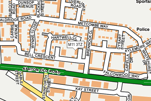
M11 3TZ is located in the Ancoats & Beswick electoral ward, within the metropolitan district of Manchester and the English Parliamentary constituency of Manchester Central. The Sub Integrated Care Board (ICB) Location is NHS Greater Manchester ICB - 14L and the police force is Greater Manchester. This postcode has been in use since August 2006.


GetTheData
Source: OS OpenMap – Local (Ordnance Survey)
Source: OS VectorMap District (Ordnance Survey)
Licence: Open Government Licence (requires attribution)
| Easting | 386738 |
| Northing | 397641 |
| Latitude | 53.475328 |
| Longitude | -2.201278 |
GetTheData
Source: Open Postcode Geo
Licence: Open Government Licence
| Country | England |
| Postcode District | M11 |
| ➜ M11 open data dashboard ➜ See where M11 is on a map ➜ Where is Manchester? | |
GetTheData
Source: Land Registry Price Paid Data
Licence: Open Government Licence
Elevation or altitude of M11 3TZ as distance above sea level:
| Metres | Feet | |
|---|---|---|
| Elevation | 50m | 164ft |
Elevation is measured from the approximate centre of the postcode, to the nearest point on an OS contour line from OS Terrain 50, which has contour spacing of ten vertical metres.
➜ How high above sea level am I? Find the elevation of your current position using your device's GPS.
GetTheData
Source: Open Postcode Elevation
Licence: Open Government Licence
| Ward | Ancoats & Beswick |
| Constituency | Manchester Central |
GetTheData
Source: ONS Postcode Database
Licence: Open Government Licence
| Ashton Old Rd/Stainforth St (Ashton Old Rd) | Beswick | 87m |
| Ashton Old Rd/Stainforth St (Ashton Old Rd) | Beswick | 110m |
| Manipur Street | Beswick | 152m |
| Ashton Old Rd/Kay St (Ashton Old Rd) | Beswick | 167m |
| Charlesworth Street (Charlesworth St) | Beswick | 186m |
| Velopark (Manchester Metrolink) (Ashton New Road) | Sportcity | 946m |
| Etihad Campus (Manchester Metrolink) (Joe Mercer Way) | Sportcity | 1,116m |
| Holt Town (Manchester Metrolink) (Holt Town) | Holt Town | 1,137m |
| New Islington (Manchester Metrolink) (Pollard Street) | New Islington | 1,384m |
| Clayton Hall (Manchester Metrolink) (Ashton New Road) | Clayton | 1,516m |
| Ashburys Station | 0.6km |
| Ardwick Station | 0.9km |
| Manchester Piccadilly Station | 2km |
GetTheData
Source: NaPTAN
Licence: Open Government Licence
| Percentage of properties with Next Generation Access | 100.0% |
| Percentage of properties with Superfast Broadband | 100.0% |
| Percentage of properties with Ultrafast Broadband | 25.0% |
| Percentage of properties with Full Fibre Broadband | 0.0% |
Superfast Broadband is between 30Mbps and 300Mbps
Ultrafast Broadband is > 300Mbps
| Percentage of properties unable to receive 2Mbps | 0.0% |
| Percentage of properties unable to receive 5Mbps | 0.0% |
| Percentage of properties unable to receive 10Mbps | 0.0% |
| Percentage of properties unable to receive 30Mbps | 0.0% |
GetTheData
Source: Ofcom
Licence: Ofcom Terms of Use (requires attribution)
GetTheData
Source: ONS Postcode Database
Licence: Open Government Licence


➜ Get more ratings from the Food Standards Agency
GetTheData
Source: Food Standards Agency
Licence: FSA terms & conditions
| Last Collection | |||
|---|---|---|---|
| Location | Mon-Fri | Sat | Distance |
| Tulley Street | 17:30 | 12:00 | 168m |
| Beswick P.o. | 17:30 | 12:00 | 437m |
| Wellington Street | 17:30 | 12:00 | 538m |
GetTheData
Source: Dracos
Licence: Creative Commons Attribution-ShareAlike
| Facility | Distance |
|---|---|
| The East Manchester Academy Grey Mare Lane, Manchester Grass Pitches, Sports Hall, Artificial Grass Pitch | 422m |
| East Manchester Leisure Centre Grey Mare Lane, Manchester Health and Fitness Gym, Swimming Pool, Studio | 501m |
| Bridge College Whitworth Street, Openshaw, Manchester Sports Hall | 620m |
GetTheData
Source: Active Places
Licence: Open Government Licence
| School | Phase of Education | Distance |
|---|---|---|
| Ashbury Meadow Primary School Rylance Street, Beswick, Manchester, M11 3NA | Primary | 407m |
| The East Manchester Academy 60 Grey Mare Lane, Beswick, Manchester, M11 3DS | Secondary | 488m |
| St Brigid's RC Primary School Grey Mare Lane, Beswick, Manchester, M11 3DR | Primary | 508m |
GetTheData
Source: Edubase
Licence: Open Government Licence
The below table lists the International Territorial Level (ITL) codes (formerly Nomenclature of Territorial Units for Statistics (NUTS) codes) and Local Administrative Units (LAU) codes for M11 3TZ:
| ITL 1 Code | Name |
|---|---|
| TLD | North West (England) |
| ITL 2 Code | Name |
| TLD3 | Greater Manchester |
| ITL 3 Code | Name |
| TLD33 | Manchester |
| LAU 1 Code | Name |
| E08000003 | Manchester |
GetTheData
Source: ONS Postcode Directory
Licence: Open Government Licence
The below table lists the Census Output Area (OA), Lower Layer Super Output Area (LSOA), and Middle Layer Super Output Area (MSOA) for M11 3TZ:
| Code | Name | |
|---|---|---|
| OA | E00175849 | |
| LSOA | E01005105 | Manchester 015C |
| MSOA | E02001059 | Manchester 015 |
GetTheData
Source: ONS Postcode Directory
Licence: Open Government Licence
| M11 3TW | Hartwell Close | 57m |
| M11 2DL | Ashton Old Road | 79m |
| M11 3LD | Brennock Close | 85m |
| M11 3BY | Metcombe Way | 115m |
| M11 3LP | Barleywood Drive | 120m |
| M11 3BQ | Chassen Close | 125m |
| M11 3TR | Wynne Close | 158m |
| M11 3DD | Overlinks Road | 168m |
| M11 3BG | Dysart Street | 170m |
| M11 2DT | Ashton Old Road | 184m |
GetTheData
Source: Open Postcode Geo; Land Registry Price Paid Data
Licence: Open Government Licence