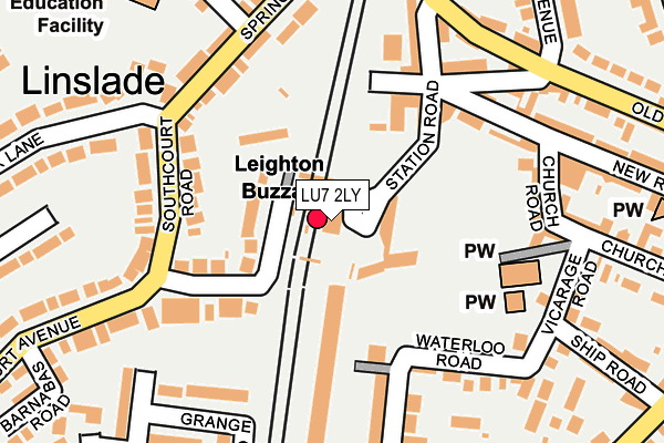
LU7 2LY is located in the Leighton-Linslade West electoral ward, within the unitary authority of Central Bedfordshire and the English Parliamentary constituency of South West Bedfordshire. The Sub Integrated Care Board (ICB) Location is NHS Bedfordshire, Luton and Milton Keynes ICB - M1J4Y and the police force is Bedfordshire. This postcode has been in use since June 2001.


GetTheData
Source: OS OpenMap – Local (Ordnance Survey)
Source: OS VectorMap District (Ordnance Survey)
Licence: Open Government Licence (requires attribution)
| Easting | 491090 |
| Northing | 225010 |
| Latitude | 51.916178 |
| Longitude | -0.677026 |
GetTheData
Source: Open Postcode Geo
Licence: Open Government Licence
| Country | England |
| Postcode District | LU7 |
| ➜ LU7 open data dashboard ➜ See where LU7 is on a map ➜ Where is Leighton Buzzard? | |
GetTheData
Source: Land Registry Price Paid Data
Licence: Open Government Licence
Elevation or altitude of LU7 2LY as distance above sea level:
| Metres | Feet | |
|---|---|---|
| Elevation | 90m | 295ft |
Elevation is measured from the approximate centre of the postcode, to the nearest point on an OS contour line from OS Terrain 50, which has contour spacing of ten vertical metres.
➜ How high above sea level am I? Find the elevation of your current position using your device's GPS.
GetTheData
Source: Open Postcode Elevation
Licence: Open Government Licence
| Ward | Leighton-linslade West |
| Constituency | South West Bedfordshire |
GetTheData
Source: ONS Postcode Database
Licence: Open Government Licence
| January 2024 | Vehicle crime | On or near Mowbray Drive | 464m |
| December 2023 | Violence and sexual offences | On or near Parking Area | 384m |
| November 2023 | Violence and sexual offences | On or near Parking Area | 384m |
| ➜ Get more crime data in our Crime section | |||
GetTheData
Source: data.police.uk
Licence: Open Government Licence
| Railway Station (Station Road) | Leighton Buzzard | 43m |
| Southcourt Road | Linslade | 141m |
| Southcourt Road | Linslade | 154m |
| Springfield Road | Linslade | 188m |
| Springfield Road | Linslade | 194m |
| Leighton Buzzard Station | 0km |
GetTheData
Source: NaPTAN
Licence: Open Government Licence
GetTheData
Source: ONS Postcode Database
Licence: Open Government Licence


➜ Get more ratings from the Food Standards Agency
GetTheData
Source: Food Standards Agency
Licence: FSA terms & conditions
| Last Collection | |||
|---|---|---|---|
| Location | Mon-Fri | Sat | Distance |
| Southcourt Avenue | 17:00 | 12:00 | 165m |
| Post Office New Road | 18:30 | 12:00 | 219m |
| Wing Road | 17:00 | 11:00 | 318m |
GetTheData
Source: Dracos
Licence: Creative Commons Attribution-ShareAlike
| Facility | Distance |
|---|---|
| The Forster Institute Waterloo Road, Leighton Buzzard Sports Hall | 229m |
| Linslade Memorial Playing Fields And Garden Of Remembrance Mentmore Road, Leighton Buzzard Grass Pitches, Outdoor Tennis Courts | 469m |
| Energie Fitness (Leighton Buzzard) Leighton Road, Linslade Health and Fitness Gym, Studio | 563m |
GetTheData
Source: Active Places
Licence: Open Government Licence
| School | Phase of Education | Distance |
|---|---|---|
| Linslade Lower School Leopold Road, Linslade, Leighton Buzzard, LU7 2QU | Primary | 282m |
| Southcott Lower School Bideford Green, Linslade, Leighton Buzzard, LU7 2UA | Primary | 662m |
| Leighton Middle School Church Square, Leighton Buzzard, LU7 1EX | Middle deemed secondary | 819m |
GetTheData
Source: Edubase
Licence: Open Government Licence
The below table lists the International Territorial Level (ITL) codes (formerly Nomenclature of Territorial Units for Statistics (NUTS) codes) and Local Administrative Units (LAU) codes for LU7 2LY:
| ITL 1 Code | Name |
|---|---|
| TLH | East |
| ITL 2 Code | Name |
| TLH2 | Bedfordshire and Hertfordshire |
| ITL 3 Code | Name |
| TLH25 | Central Bedfordshire |
| LAU 1 Code | Name |
| E06000056 | Central Bedfordshire |
GetTheData
Source: ONS Postcode Directory
Licence: Open Government Licence
The below table lists the Census Output Area (OA), Lower Layer Super Output Area (LSOA), and Middle Layer Super Output Area (MSOA) for LU7 2LY:
| Code | Name | |
|---|---|---|
| OA | E00088793 | |
| LSOA | E01017589 | Central Bedfordshire 022A |
| MSOA | E02003640 | Central Bedfordshire 022 |
GetTheData
Source: ONS Postcode Directory
Licence: Open Government Licence
| LU7 2PX | Old Road | 94m |
| LU7 2QE | Southcourt Avenue | 104m |
| LU7 2RG | Old Road | 122m |
| LU7 2AQ | Old Road | 134m |
| LU7 2AS | Station Road | 146m |
| LU7 2LU | New Road | 172m |
| LU7 2QF | Southcourt Road | 177m |
| LU7 2NF | Station Road | 178m |
| LU7 2NR | Waterloo Road | 178m |
| LU7 2QD | Southcourt Avenue | 182m |
GetTheData
Source: Open Postcode Geo; Land Registry Price Paid Data
Licence: Open Government Licence