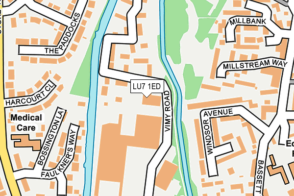
LU7 1ED is located in the Leighton-Linslade West electoral ward, within the unitary authority of Central Bedfordshire and the English Parliamentary constituency of South West Bedfordshire. The Sub Integrated Care Board (ICB) Location is NHS Bedfordshire, Luton and Milton Keynes ICB - M1J4Y and the police force is Bedfordshire. This postcode has been in use since June 2001.


GetTheData
Source: OS OpenMap – Local (Ordnance Survey)
Source: OS VectorMap District (Ordnance Survey)
Licence: Open Government Licence (requires attribution)
| Easting | 491677 |
| Northing | 225371 |
| Latitude | 51.919327 |
| Longitude | -0.668397 |
GetTheData
Source: Open Postcode Geo
Licence: Open Government Licence
| Country | England |
| Postcode District | LU7 |
| ➜ LU7 open data dashboard ➜ See where LU7 is on a map ➜ Where is Leighton Buzzard? | |
GetTheData
Source: Land Registry Price Paid Data
Licence: Open Government Licence
Elevation or altitude of LU7 1ED as distance above sea level:
| Metres | Feet | |
|---|---|---|
| Elevation | 80m | 262ft |
Elevation is measured from the approximate centre of the postcode, to the nearest point on an OS contour line from OS Terrain 50, which has contour spacing of ten vertical metres.
➜ How high above sea level am I? Find the elevation of your current position using your device's GPS.
GetTheData
Source: Open Postcode Elevation
Licence: Open Government Licence
| Ward | Leighton-linslade West |
| Constituency | South West Bedfordshire |
GetTheData
Source: ONS Postcode Database
Licence: Open Government Licence
| January 2024 | Violence and sexual offences | On or near Bridge Street | 406m |
| January 2024 | Violence and sexual offences | On or near Bridge Street | 406m |
| December 2023 | Burglary | On or near Windsor Avenue | 198m |
| ➜ Get more crime data in our Crime section | |||
GetTheData
Source: data.police.uk
Licence: Open Government Licence
| Tesco (Leighton Road) | Leighton Buzzard | 243m |
| Bridge Street (Leighton Road) | Leighton Buzzard | 357m |
| Tesco (Leighton Road) | Leighton Buzzard | 363m |
| Roseberry Avenue | Leighton Buzzard | 367m |
| Stoke Road (Old Road) | Linslade | 382m |
| Leighton Buzzard Station | 0.7km |
GetTheData
Source: NaPTAN
Licence: Open Government Licence
GetTheData
Source: ONS Postcode Database
Licence: Open Government Licence


➜ Get more ratings from the Food Standards Agency
GetTheData
Source: Food Standards Agency
Licence: FSA terms & conditions
| Last Collection | |||
|---|---|---|---|
| Location | Mon-Fri | Sat | Distance |
| Stoke Road | 17:15 | 12:00 | 289m |
| Ashwell Street | 17:00 | 12:00 | 364m |
| Golden Riddy | 17:15 | 12:00 | 424m |
GetTheData
Source: Dracos
Licence: Creative Commons Attribution-ShareAlike
| Facility | Distance |
|---|---|
| Energie Fitness (Leighton Buzzard) Leighton Road, Linslade Health and Fitness Gym, Studio | 394m |
| Leighton Middle School Church Square, Leighton Buzzard Sports Hall, Grass Pitches | 460m |
| The Forster Institute Waterloo Road, Leighton Buzzard Sports Hall | 663m |
GetTheData
Source: Active Places
Licence: Open Government Licence
| School | Phase of Education | Distance |
|---|---|---|
| The Mary Bassett Lower School Bassett Road, Leighton Buzzard, LU7 1AR | Primary | 297m |
| Leighton Middle School Church Square, Leighton Buzzard, LU7 1EX | Middle deemed secondary | 460m |
| Pulford CofE VA Lower School Pulford Road, Leighton Buzzard, LU7 1AB | Primary | 675m |
GetTheData
Source: Edubase
Licence: Open Government Licence
The below table lists the International Territorial Level (ITL) codes (formerly Nomenclature of Territorial Units for Statistics (NUTS) codes) and Local Administrative Units (LAU) codes for LU7 1ED:
| ITL 1 Code | Name |
|---|---|
| TLH | East |
| ITL 2 Code | Name |
| TLH2 | Bedfordshire and Hertfordshire |
| ITL 3 Code | Name |
| TLH25 | Central Bedfordshire |
| LAU 1 Code | Name |
| E06000056 | Central Bedfordshire |
GetTheData
Source: ONS Postcode Directory
Licence: Open Government Licence
The below table lists the Census Output Area (OA), Lower Layer Super Output Area (LSOA), and Middle Layer Super Output Area (MSOA) for LU7 1ED:
| Code | Name | |
|---|---|---|
| OA | E00088615 | |
| LSOA | E01017557 | Central Bedfordshire 021C |
| MSOA | E02003639 | Central Bedfordshire 021 |
GetTheData
Source: ONS Postcode Directory
Licence: Open Government Licence
| LU7 1FG | Vimy Court | 68m |
| LU7 3WJ | Millstream Way | 172m |
| LU7 1AP | Windsor Avenue | 179m |
| LU7 1YX | Croxley Court | 195m |
| LU7 1LH | Leighton Road | 220m |
| LU7 2TB | Bossington Lane | 221m |
| LU7 2SX | The Paddocks | 227m |
| LU7 2ST | Harcourt Close | 238m |
| LU7 2SS | Faulkners Way | 238m |
| LU7 1YY | Basildon Court | 243m |
GetTheData
Source: Open Postcode Geo; Land Registry Price Paid Data
Licence: Open Government Licence