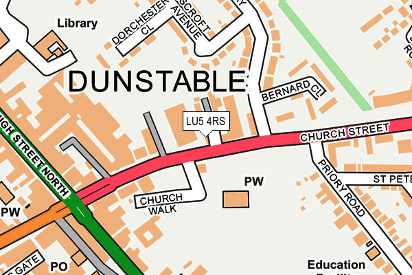
LU5 4RS is located in the Dunstable East electoral ward, within the unitary authority of Central Bedfordshire and the English Parliamentary constituency of South West Bedfordshire. The Sub Integrated Care Board (ICB) Location is NHS Bedfordshire, Luton and Milton Keynes ICB - M1J4Y and the police force is Bedfordshire. This postcode has been in use since January 1980.


GetTheData
Source: OS OpenMap – Local (Ordnance Survey)
Source: OS VectorMap District (Ordnance Survey)
Licence: Open Government Licence (requires attribution)
| Easting | 502085 |
| Northing | 221958 |
| Latitude | 51.886843 |
| Longitude | -0.518124 |
GetTheData
Source: Open Postcode Geo
Licence: Open Government Licence
| Country | England |
| Postcode District | LU5 |
| ➜ LU5 open data dashboard ➜ See where LU5 is on a map ➜ Where is Dunstable? | |
GetTheData
Source: Land Registry Price Paid Data
Licence: Open Government Licence
Elevation or altitude of LU5 4RS as distance above sea level:
| Metres | Feet | |
|---|---|---|
| Elevation | 140m | 459ft |
Elevation is measured from the approximate centre of the postcode, to the nearest point on an OS contour line from OS Terrain 50, which has contour spacing of ten vertical metres.
➜ How high above sea level am I? Find the elevation of your current position using your device's GPS.
GetTheData
Source: Open Postcode Elevation
Licence: Open Government Licence
| Ward | Dunstable East |
| Constituency | South West Bedfordshire |
GetTheData
Source: ONS Postcode Database
Licence: Open Government Licence
| January 2024 | Criminal damage and arson | On or near Parking Area | 338m |
| January 2024 | Theft from the person | On or near Parking Area | 338m |
| January 2024 | Violence and sexual offences | On or near Parking Area | 338m |
| ➜ Get more crime data in our Crime section | |||
GetTheData
Source: data.police.uk
Licence: Open Government Licence
| The Winston Churchill (Church Street) | Dunstable | 90m |
| The Winston Churchill (Church Street) | Dunstable | 101m |
| The Winston Churchill (Church Street) | Dunstable | 116m |
| The Quadrant (High Street North) | Dunstable | 248m |
| The Square | Dunstable | 248m |
| Leagrave Station | 4.6km |
GetTheData
Source: NaPTAN
Licence: Open Government Licence
GetTheData
Source: ONS Postcode Database
Licence: Open Government Licence


➜ Get more ratings from the Food Standards Agency
GetTheData
Source: Food Standards Agency
Licence: FSA terms & conditions
| Last Collection | |||
|---|---|---|---|
| Location | Mon-Fri | Sat | Distance |
| Kingscroft Avenue | 17:45 | 11:30 | 98m |
| Broadwalk | 17:30 | 11:45 | 140m |
| Church Street | 17:30 | 11:30 | 142m |
GetTheData
Source: Dracos
Licence: Creative Commons Attribution-ShareAlike
| Facility | Distance |
|---|---|
| Priory Academy Britain Street, Dunstable Sports Hall, Grass Pitches | 330m |
| Rise Fitness (Dunstable) Kingsway, Dunstable Health and Fitness Gym | 439m |
| Energie Fitness Club (Dunstable) (Closed) High Street North, Dunstable Studio, Health and Fitness Gym | 464m |
GetTheData
Source: Active Places
Licence: Open Government Licence
| School | Phase of Education | Distance |
|---|---|---|
| Priory Academy Priory Academy, Britain Street, Dunstable, LU5 4JA | All-through | 330m |
| Dunstable Icknield Lower School Burr Street, Dunstable, LU6 3AG | Primary | 601m |
| Watling Lower School Bull Pond Lane, Dunstable, LU6 3BJ | Primary | 769m |
GetTheData
Source: Edubase
Licence: Open Government Licence
The below table lists the International Territorial Level (ITL) codes (formerly Nomenclature of Territorial Units for Statistics (NUTS) codes) and Local Administrative Units (LAU) codes for LU5 4RS:
| ITL 1 Code | Name |
|---|---|
| TLH | East |
| ITL 2 Code | Name |
| TLH2 | Bedfordshire and Hertfordshire |
| ITL 3 Code | Name |
| TLH25 | Central Bedfordshire |
| LAU 1 Code | Name |
| E06000056 | Central Bedfordshire |
GetTheData
Source: ONS Postcode Directory
Licence: Open Government Licence
The below table lists the Census Output Area (OA), Lower Layer Super Output Area (LSOA), and Middle Layer Super Output Area (MSOA) for LU5 4RS:
| Code | Name | |
|---|---|---|
| OA | E00088683 | |
| LSOA | E01017570 | Central Bedfordshire 029E |
| MSOA | E02003647 | Central Bedfordshire 029 |
GetTheData
Source: ONS Postcode Directory
Licence: Open Government Licence
| LU5 4RP | Church Street | 56m |
| LU5 4RQ | Church Street | 81m |
| LU5 4RU | Church Street | 147m |
| LU5 4HD | Kingsway | 161m |
| LU5 4HJ | Dorchester Close | 163m |
| LU5 4HQ | Kingscroft Avenue | 175m |
| LU5 4HL | Bernard Close | 190m |
| LU6 3RZ | High Street South | 194m |
| LU6 3SE | High Street South | 194m |
| LU6 1TD | Nicholas Way | 223m |
GetTheData
Source: Open Postcode Geo; Land Registry Price Paid Data
Licence: Open Government Licence