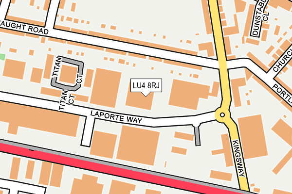
LU4 8RJ is located in the Beech Hill electoral ward, within the unitary authority of Luton and the English Parliamentary constituency of Luton South. The Sub Integrated Care Board (ICB) Location is NHS Bedfordshire, Luton and Milton Keynes ICB - M1J4Y and the police force is Bedfordshire. This postcode has been in use since December 1994.


GetTheData
Source: OS OpenMap – Local (Ordnance Survey)
Source: OS VectorMap District (Ordnance Survey)
Licence: Open Government Licence (requires attribution)
| Easting | 507044 |
| Northing | 222198 |
| Latitude | 51.888071 |
| Longitude | -0.446024 |
GetTheData
Source: Open Postcode Geo
Licence: Open Government Licence
| Country | England |
| Postcode District | LU4 |
| ➜ LU4 open data dashboard ➜ See where LU4 is on a map ➜ Where is Luton? | |
GetTheData
Source: Land Registry Price Paid Data
Licence: Open Government Licence
Elevation or altitude of LU4 8RJ as distance above sea level:
| Metres | Feet | |
|---|---|---|
| Elevation | 120m | 394ft |
Elevation is measured from the approximate centre of the postcode, to the nearest point on an OS contour line from OS Terrain 50, which has contour spacing of ten vertical metres.
➜ How high above sea level am I? Find the elevation of your current position using your device's GPS.
GetTheData
Source: Open Postcode Elevation
Licence: Open Government Licence
| Ward | Beech Hill |
| Constituency | Luton South |
GetTheData
Source: ONS Postcode Database
Licence: Open Government Licence
| January 2024 | Other crime | On or near Crosby Close | 357m |
| January 2024 | Violence and sexual offences | On or near Chandos Road | 390m |
| December 2023 | Anti-social behaviour | On or near Crosby Close | 357m |
| ➜ Get more crime data in our Crime section | |||
GetTheData
Source: data.police.uk
Licence: Open Government Licence
| Kingsway (Dunstable Road) | Maidenhall | 315m |
| Kingsway (Dunstable Road) | Maidenhall | 319m |
| Arundel Road (Dunstable Road) | Maidenhall | 333m |
| Arundel Road (Dunstable Road) | Maidenhall | 447m |
| Lincoln Road (Dunstable Road) | Maidenhall | 474m |
| Leagrave Station | 2.1km |
| Luton Station | 2.3km |
| Luton Airport Parkway Station | 3.9km |
GetTheData
Source: NaPTAN
Licence: Open Government Licence
GetTheData
Source: ONS Postcode Database
Licence: Open Government Licence


➜ Get more ratings from the Food Standards Agency
GetTheData
Source: Food Standards Agency
Licence: FSA terms & conditions
| Last Collection | |||
|---|---|---|---|
| Location | Mon-Fri | Sat | Distance |
| Laporte Way | 18:30 | 90m | |
| Portland Court | 18:30 | 12:00 | 193m |
| Connaught Road | 17:30 | 12:00 | 225m |
GetTheData
Source: Dracos
Licence: Creative Commons Attribution-ShareAlike
| Facility | Distance |
|---|---|
| Kingsway Recreation Ground Beverley Road, Luton Grass Pitches | 284m |
| Maidenhall Primary School Newark Road, Luton Grass Pitches | 449m |
| Foxdell Community Education Centre Runley Road, Luton Sports Hall | 566m |
GetTheData
Source: Active Places
Licence: Open Government Licence
| School | Phase of Education | Distance |
|---|---|---|
| Foxdell Primary School Dallow Road, Luton, LU1 1TG | Primary | 518m |
| Maidenhall Primary School Newark Road, Luton, LU4 8LD | Primary | 536m |
| Downside Primary School Chaul End Lane, Luton, LU4 8EZ | Primary | 811m |
GetTheData
Source: Edubase
Licence: Open Government Licence
The below table lists the International Territorial Level (ITL) codes (formerly Nomenclature of Territorial Units for Statistics (NUTS) codes) and Local Administrative Units (LAU) codes for LU4 8RJ:
| ITL 1 Code | Name |
|---|---|
| TLH | East |
| ITL 2 Code | Name |
| TLH2 | Bedfordshire and Hertfordshire |
| ITL 3 Code | Name |
| TLH21 | Luton |
| LAU 1 Code | Name |
| E06000032 | Luton |
GetTheData
Source: ONS Postcode Directory
Licence: Open Government Licence
The below table lists the Census Output Area (OA), Lower Layer Super Output Area (LSOA), and Middle Layer Super Output Area (MSOA) for LU4 8RJ:
| Code | Name | |
|---|---|---|
| OA | E00079518 | |
| LSOA | E01015731 | Luton 015C |
| MSOA | E02003272 | Luton 015 |
GetTheData
Source: ONS Postcode Directory
Licence: Open Government Licence
| LU4 8EP | Connaught Road | 83m |
| LU4 8ER | Connaught Road | 167m |
| LU4 8EF | Titan Court | 168m |
| LU4 8EJ | Kingsway | 182m |
| LU4 8EH | Kingsway | 220m |
| LU4 8AY | Portland Road | 268m |
| LU1 1DE | Dallow Road | 277m |
| LU4 8DP | Dunstable Close | 280m |
| LU4 8DA | Dunstable Road | 290m |
| LU1 1TR | Finway | 293m |
GetTheData
Source: Open Postcode Geo; Land Registry Price Paid Data
Licence: Open Government Licence