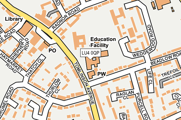
LU4 0QP is located in the Lewsey electoral ward, within the unitary authority of Luton and the English Parliamentary constituency of Luton North. The Sub Integrated Care Board (ICB) Location is NHS Bedfordshire, Luton and Milton Keynes ICB - M1J4Y and the police force is Bedfordshire. This postcode has been in use since January 1980.


GetTheData
Source: OS OpenMap – Local (Ordnance Survey)
Source: OS VectorMap District (Ordnance Survey)
Licence: Open Government Licence (requires attribution)
| Easting | 503737 |
| Northing | 223597 |
| Latitude | 51.901269 |
| Longitude | -0.493637 |
GetTheData
Source: Open Postcode Geo
Licence: Open Government Licence
| Country | England |
| Postcode District | LU4 |
| ➜ LU4 open data dashboard ➜ See where LU4 is on a map ➜ Where is Luton? | |
GetTheData
Source: Land Registry Price Paid Data
Licence: Open Government Licence
Elevation or altitude of LU4 0QP as distance above sea level:
| Metres | Feet | |
|---|---|---|
| Elevation | 130m | 427ft |
Elevation is measured from the approximate centre of the postcode, to the nearest point on an OS contour line from OS Terrain 50, which has contour spacing of ten vertical metres.
➜ How high above sea level am I? Find the elevation of your current position using your device's GPS.
GetTheData
Source: Open Postcode Elevation
Licence: Open Government Licence
| Ward | Lewsey |
| Constituency | Luton North |
GetTheData
Source: ONS Postcode Database
Licence: Open Government Licence
| January 2024 | Violence and sexual offences | On or near Wedgewood Road | 144m |
| January 2024 | Violence and sexual offences | On or near Wedgewood Road | 144m |
| January 2024 | Violence and sexual offences | On or near Wedgewood Road | 144m |
| ➜ Get more crime data in our Crime section | |||
GetTheData
Source: data.police.uk
Licence: Open Government Licence
| Brunel Road (Tomlinson Avenue) | Lewsey Farm | 79m |
| St Dominics Square (Tomlinson Avenue) | Lewsey Farm | 135m |
| Brunel Road (Tomlinson Avenue) | Lewsey Farm | 142m |
| St Dominics Square (Tomlinson Avenue) | Lewsey Farm | 173m |
| Landrace Road (Tomlinson Avenue) | Lewsey Farm | 288m |
| Leagrave Station | 2.5km |
GetTheData
Source: NaPTAN
Licence: Open Government Licence
GetTheData
Source: ONS Postcode Database
Licence: Open Government Licence


➜ Get more ratings from the Food Standards Agency
GetTheData
Source: Food Standards Agency
Licence: FSA terms & conditions
| Last Collection | |||
|---|---|---|---|
| Location | Mon-Fri | Sat | Distance |
| Post Office Lewsey Farm | 17:30 | 12:30 | 158m |
| Wheatfield Court | 17:30 | 12:15 | 418m |
| Jersey Road | 17:30 | 12:30 | 424m |
GetTheData
Source: Dracos
Licence: Creative Commons Attribution-ShareAlike
| Facility | Distance |
|---|---|
| Chantry Primary Academy Tomlinson Avenue, Luton Grass Pitches | 0m |
| St Martin De Porres Primary School Pastures Way, Luton Grass Pitches | 471m |
| The Chalk Hills Academy Leagrave High Street, Luton Sports Hall, Health and Fitness Gym, Artificial Grass Pitch, Grass Pitches, Studio | 514m |
GetTheData
Source: Active Places
Licence: Open Government Licence
| School | Phase of Education | Distance |
|---|---|---|
| Chantry Primary Academy Tomlinson Avenue, Luton, LU4 0QP | Primary | 1m |
| Southfield Primary Academy Pastures Way, Luton, LU4 0PE | Primary | 304m |
| Pastures Way Nursery School Pastures Way, Luton, LU4 0PE | Nursery | 342m |
GetTheData
Source: Edubase
Licence: Open Government Licence
The below table lists the International Territorial Level (ITL) codes (formerly Nomenclature of Territorial Units for Statistics (NUTS) codes) and Local Administrative Units (LAU) codes for LU4 0QP:
| ITL 1 Code | Name |
|---|---|
| TLH | East |
| ITL 2 Code | Name |
| TLH2 | Bedfordshire and Hertfordshire |
| ITL 3 Code | Name |
| TLH21 | Luton |
| LAU 1 Code | Name |
| E06000032 | Luton |
GetTheData
Source: ONS Postcode Directory
Licence: Open Government Licence
The below table lists the Census Output Area (OA), Lower Layer Super Output Area (LSOA), and Middle Layer Super Output Area (MSOA) for LU4 0QP:
| Code | Name | |
|---|---|---|
| OA | E00079671 | |
| LSOA | E01015759 | Luton 009D |
| MSOA | E02003266 | Luton 009 |
GetTheData
Source: ONS Postcode Directory
Licence: Open Government Licence
| LU4 0QY | Beadlow Road | 92m |
| LU4 0RU | Thurlow Close | 103m |
| LU4 0RE | Raglan Close | 134m |
| LU4 0QL | Tomlinson Avenue | 159m |
| LU4 0RG | Wedgewood Road | 162m |
| LU4 0SU | Thatch Close | 167m |
| LU4 0RX | Brunel Road | 168m |
| LU4 0QW | Tomlinson Avenue | 173m |
| LU4 0UG | Radnor Road | 175m |
| LU4 0UQ | Radnor Road | 214m |
GetTheData
Source: Open Postcode Geo; Land Registry Price Paid Data
Licence: Open Government Licence