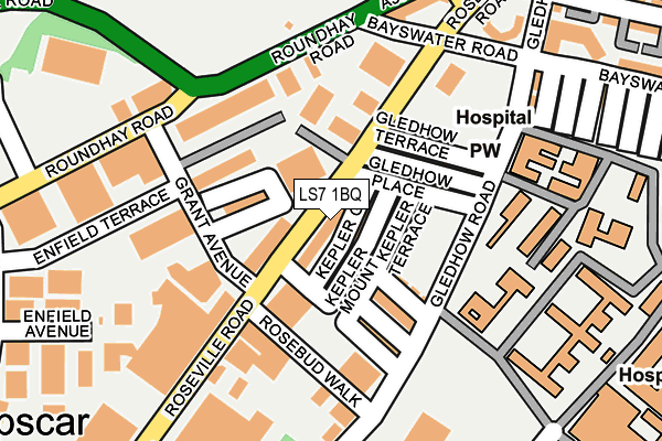
LS7 1BQ is located in the Gipton & Harehills electoral ward, within the metropolitan district of Leeds and the English Parliamentary constituency of Leeds East. The Sub Integrated Care Board (ICB) Location is NHS West Yorkshire ICB - 15F and the police force is West Yorkshire. This postcode has been in use since December 1996.


GetTheData
Source: OS OpenMap – Local (Ordnance Survey)
Source: OS VectorMap District (Ordnance Survey)
Licence: Open Government Licence (requires attribution)
| Easting | 431309 |
| Northing | 434866 |
| Latitude | 53.809164 |
| Longitude | -1.526032 |
GetTheData
Source: Open Postcode Geo
Licence: Open Government Licence
| Country | England |
| Postcode District | LS7 |
| ➜ LS7 open data dashboard ➜ See where LS7 is on a map ➜ Where is Leeds? | |
GetTheData
Source: Land Registry Price Paid Data
Licence: Open Government Licence
Elevation or altitude of LS7 1BQ as distance above sea level:
| Metres | Feet | |
|---|---|---|
| Elevation | 40m | 131ft |
Elevation is measured from the approximate centre of the postcode, to the nearest point on an OS contour line from OS Terrain 50, which has contour spacing of ten vertical metres.
➜ How high above sea level am I? Find the elevation of your current position using your device's GPS.
GetTheData
Source: Open Postcode Elevation
Licence: Open Government Licence
| Ward | Gipton & Harehills |
| Constituency | Leeds East |
GetTheData
Source: ONS Postcode Database
Licence: Open Government Licence
| June 2022 | Anti-social behaviour | On or near Gledhow Place | 71m |
| June 2022 | Criminal damage and arson | On or near Gledhow Place | 71m |
| June 2022 | Shoplifting | On or near Roseville Road | 79m |
| ➜ Get more crime data in our Crime section | |||
GetTheData
Source: data.police.uk
Licence: Open Government Licence
| Roseville Rd Roseville Street (Roseville Road) | Harehills | 72m |
| Roseville Rd Roseville Street (Roseville Road) | Harehills | 96m |
| Roundhay Rd Barrack Road (Roundhay Road) | Harehills | 147m |
| Roundhay Rd Barrack Road (Roundhay Road) | Harehills | 159m |
| Roundhay Road Spencer Place (Roundhay Road) | Harehills | 198m |
| Leeds Station | 2.1km |
| Burley Park Station | 3.4km |
| Headingley Station | 4.6km |
GetTheData
Source: NaPTAN
Licence: Open Government Licence
GetTheData
Source: ONS Postcode Database
Licence: Open Government Licence

➜ Get more ratings from the Food Standards Agency
GetTheData
Source: Food Standards Agency
Licence: FSA terms & conditions
| Last Collection | |||
|---|---|---|---|
| Location | Mon-Fri | Sat | Distance |
| Opp Spencer Place/Roundhay Road | 17:45 | 11:15 | 164m |
| St James Hospital | 18:00 | 11:00 | 459m |
| Leopold Street | 14:45 | 11:30 | 462m |
GetTheData
Source: Dracos
Licence: Creative Commons Attribution-ShareAlike
| Facility | Distance |
|---|---|
| Peak Fitness Gym (Closed) Roseville Road, Leeds Health and Fitness Gym | 164m |
| Dixons Trinity Chapeltown Leopold Street, Leopold Street, Leeds Sports Hall | 302m |
| Leeds Thomas Danby Community Sports Centre (Closed) Roundhay Road, Leeds Health and Fitness Gym, Artificial Grass Pitch, Studio | 307m |
GetTheData
Source: Active Places
Licence: Open Government Licence
| School | Phase of Education | Distance |
|---|---|---|
| Shakespeare Primary School Lincoln Road, Leeds, LS9 7NP | Primary | 475m |
| Holy Rosary and St Anne's Catholic Primary School, a Voluntary Academy Leopold Street, Chapeltown, Leeds, LS7 4AW | Primary | 562m |
| Dixons Trinity Chapeltown Leopold Street, Chapeltown, Leeds, LS7 4AW | All-through | 569m |
GetTheData
Source: Edubase
Licence: Open Government Licence
The below table lists the International Territorial Level (ITL) codes (formerly Nomenclature of Territorial Units for Statistics (NUTS) codes) and Local Administrative Units (LAU) codes for LS7 1BQ:
| ITL 1 Code | Name |
|---|---|
| TLE | Yorkshire and The Humber |
| ITL 2 Code | Name |
| TLE4 | West Yorkshire |
| ITL 3 Code | Name |
| TLE42 | Leeds |
| LAU 1 Code | Name |
| E08000035 | Leeds |
GetTheData
Source: ONS Postcode Directory
Licence: Open Government Licence
The below table lists the Census Output Area (OA), Lower Layer Super Output Area (LSOA), and Middle Layer Super Output Area (MSOA) for LS7 1BQ:
| Code | Name | |
|---|---|---|
| OA | E00058854 | |
| LSOA | E01011673 | Leeds 064B |
| MSOA | E02002393 | Leeds 064 |
GetTheData
Source: ONS Postcode Directory
Licence: Open Government Licence
| LS8 5EJ | Kepler Mount | 31m |
| LS8 5EL | Kepler Grove | 36m |
| LS8 5EH | Kepler Terrace | 49m |
| LS8 5EN | Gledhow Place | 76m |
| LS8 5EW | Gledhow Mount | 78m |
| LS8 5EP | Gledhow Terrace | 94m |
| LS8 5EQ | Anderson Mount | 99m |
| LS8 5EG | Anderson Avenue | 114m |
| LS8 5ES | Gledhow Road | 125m |
| LS8 5DT | Roseville Road | 130m |
GetTheData
Source: Open Postcode Geo; Land Registry Price Paid Data
Licence: Open Government Licence