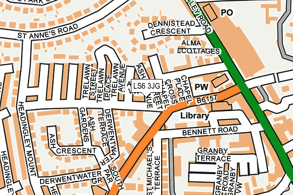
LS6 3JG is located in the Headingley & Hyde Park electoral ward, within the metropolitan district of Leeds and the English Parliamentary constituency of Leeds North West. The Sub Integrated Care Board (ICB) Location is NHS West Yorkshire ICB - 15F and the police force is West Yorkshire. This postcode has been in use since January 1980.


GetTheData
Source: OS OpenMap – Local (Ordnance Survey)
Source: OS VectorMap District (Ordnance Survey)
Licence: Open Government Licence (requires attribution)
| Easting | 427701 |
| Northing | 436172 |
| Latitude | 53.821090 |
| Longitude | -1.580699 |
GetTheData
Source: Open Postcode Geo
Licence: Open Government Licence
| Country | England |
| Postcode District | LS6 |
| ➜ LS6 open data dashboard ➜ See where LS6 is on a map ➜ Where is Leeds? | |
GetTheData
Source: Land Registry Price Paid Data
Licence: Open Government Licence
Elevation or altitude of LS6 3JG as distance above sea level:
| Metres | Feet | |
|---|---|---|
| Elevation | 90m | 295ft |
Elevation is measured from the approximate centre of the postcode, to the nearest point on an OS contour line from OS Terrain 50, which has contour spacing of ten vertical metres.
➜ How high above sea level am I? Find the elevation of your current position using your device's GPS.
GetTheData
Source: Open Postcode Elevation
Licence: Open Government Licence
| Ward | Headingley & Hyde Park |
| Constituency | Leeds North West |
GetTheData
Source: ONS Postcode Database
Licence: Open Government Licence
| November 2023 | Violence and sexual offences | On or near Estcourt Terrace | 445m |
| October 2023 | Anti-social behaviour | On or near North Lane | 67m |
| October 2023 | Violence and sexual offences | On or near North Lane | 67m |
| ➜ Get more crime data in our Crime section | |||
GetTheData
Source: data.police.uk
Licence: Open Government Licence
| North Lane Otley Rd (North Lane) | Headingley | 131m |
| North Lane Library (North Lane) | Headingley | 146m |
| Arndale Centre (Otley Road) | Headingley | 175m |
| Arndale Centre (Otley Road) | Headingley | 190m |
| Carnegie Stadium (Kirkstall Lane) | Headingley | 263m |
| Headingley Station | 1km |
| Burley Park Station | 1km |
| Kirkstall Forge Station | 2.8km |
GetTheData
Source: NaPTAN
Licence: Open Government Licence
| Percentage of properties with Next Generation Access | 100.0% |
| Percentage of properties with Superfast Broadband | 100.0% |
| Percentage of properties with Ultrafast Broadband | 100.0% |
| Percentage of properties with Full Fibre Broadband | 100.0% |
Superfast Broadband is between 30Mbps and 300Mbps
Ultrafast Broadband is > 300Mbps
| Percentage of properties unable to receive 2Mbps | 0.0% |
| Percentage of properties unable to receive 5Mbps | 0.0% |
| Percentage of properties unable to receive 10Mbps | 0.0% |
| Percentage of properties unable to receive 30Mbps | 0.0% |
GetTheData
Source: Ofcom
Licence: Ofcom Terms of Use (requires attribution)
GetTheData
Source: ONS Postcode Database
Licence: Open Government Licence


➜ Get more ratings from the Food Standards Agency
GetTheData
Source: Food Standards Agency
Licence: FSA terms & conditions
| Last Collection | |||
|---|---|---|---|
| Location | Mon-Fri | Sat | Distance |
| Ash Road/North Lane | 17:30 | 11:00 | 38m |
| Headingley Po Box | 18:30 | 12:15 | 207m |
| Headingley Post Office | 18:30 | 12:15 | 207m |
GetTheData
Source: Dracos
Licence: Creative Commons Attribution-ShareAlike
| Facility | Distance |
|---|---|
| The Gym Group (Leeds Headingley) Otley Road, Headingley, Leeds Health and Fitness Gym | 203m |
| Headingley Cricket Ground Kirkstall Lane, Leeds Health and Fitness Gym, Grass Pitches | 382m |
| Shire Oak Ce Primary School Wood Lane, Headingley, Leeds Grass Pitches | 456m |
GetTheData
Source: Active Places
Licence: Open Government Licence
| School | Phase of Education | Distance |
|---|---|---|
| Lighthouse Futures Trust Carlton House, 3-5 Alma Road, Leeds, LS6 2AH | Not applicable | 394m |
| Shire Oak VC Primary School Wood Lane, Headingley, Leeds, LS6 2DT | Primary | 457m |
| Spring Bank Primary School Spring Road, Headingley, Leeds, LS6 1AD | Primary | 562m |
GetTheData
Source: Edubase
Licence: Open Government Licence
The below table lists the International Territorial Level (ITL) codes (formerly Nomenclature of Territorial Units for Statistics (NUTS) codes) and Local Administrative Units (LAU) codes for LS6 3JG:
| ITL 1 Code | Name |
|---|---|
| TLE | Yorkshire and The Humber |
| ITL 2 Code | Name |
| TLE4 | West Yorkshire |
| ITL 3 Code | Name |
| TLE42 | Leeds |
| LAU 1 Code | Name |
| E08000035 | Leeds |
GetTheData
Source: ONS Postcode Directory
Licence: Open Government Licence
The below table lists the Census Output Area (OA), Lower Layer Super Output Area (LSOA), and Middle Layer Super Output Area (MSOA) for LS6 3JG:
| Code | Name | |
|---|---|---|
| OA | E00057683 | |
| LSOA | E01011440 | Leeds 044D |
| MSOA | E02002373 | Leeds 044 |
GetTheData
Source: ONS Postcode Directory
Licence: Open Government Licence
| LS6 3JH | Ash View | 21m |
| LS6 3JE | Cross Chapel Street | 26m |
| LS6 3JJ | Ash Road | 59m |
| LS6 3JQ | Trelawn Terrace | 61m |
| LS6 3JD | Ash Terrace | 62m |
| LS6 3HY | Chapel Place | 76m |
| LS6 3JN | Trelawn Avenue | 84m |
| LS6 3JL | Derwentwater Terrace | 93m |
| LS6 3HZ | Chapel Street | 97m |
| LS6 3HE | North Lane | 99m |
GetTheData
Source: Open Postcode Geo; Land Registry Price Paid Data
Licence: Open Government Licence