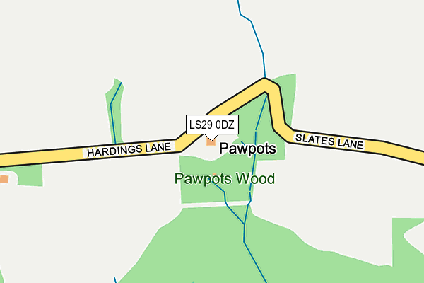
LS29 0DZ lies on Hardings Lane in Ilkley. LS29 0DZ is located in the Ilkley electoral ward, within the metropolitan district of Bradford and the English Parliamentary constituency of Keighley. The Sub Integrated Care Board (ICB) Location is NHS West Yorkshire ICB - 36J and the police force is West Yorkshire. This postcode has been in use since January 1980.


GetTheData
Source: OS OpenMap – Local (Ordnance Survey)
Source: OS VectorMap District (Ordnance Survey)
Licence: Open Government Licence (requires attribution)
| Easting | 411580 |
| Northing | 449141 |
| Latitude | 53.938258 |
| Longitude | -1.825093 |
GetTheData
Source: Open Postcode Geo
Licence: Open Government Licence
| Street | Hardings Lane |
| Town/City | Ilkley |
| Country | England |
| Postcode District | LS29 |
| ➜ LS29 open data dashboard ➜ See where LS29 is on a map | |
GetTheData
Source: Land Registry Price Paid Data
Licence: Open Government Licence
Elevation or altitude of LS29 0DZ as distance above sea level:
| Metres | Feet | |
|---|---|---|
| Elevation | 170m | 558ft |
Elevation is measured from the approximate centre of the postcode, to the nearest point on an OS contour line from OS Terrain 50, which has contour spacing of ten vertical metres.
➜ How high above sea level am I? Find the elevation of your current position using your device's GPS.
GetTheData
Source: Open Postcode Elevation
Licence: Open Government Licence
| Ward | Ilkley |
| Constituency | Keighley |
GetTheData
Source: ONS Postcode Database
Licence: Open Government Licence
| November 2021 | Violence and sexual offences | On or near Coppy Wood Drive | 417m |
| ➜ Hardings Lane crime map and outcomes | |||
GetTheData
Source: data.police.uk
Licence: Open Government Licence
| Rupert Road Gilstead Wy (Rupert Road) | Ilkley | 704m |
| Denton Road | Ilkley | 933m |
| Clifford Road | Ilkley | 968m |
| Leeds Rd Thwaites Avenue (Leeds Road) | Ilkley | 1,234m |
| New Brook Street | Ilkley | 1,239m |
| Ilkley Station | 1.5km |
| Ben Rhydding Station | 2.3km |
| Burley-in-Wharfedale Station | 5.8km |
GetTheData
Source: NaPTAN
Licence: Open Government Licence
| Percentage of properties with Next Generation Access | 100.0% |
| Percentage of properties with Superfast Broadband | 0.0% |
| Percentage of properties with Ultrafast Broadband | 0.0% |
| Percentage of properties with Full Fibre Broadband | 0.0% |
Superfast Broadband is between 30Mbps and 300Mbps
Ultrafast Broadband is > 300Mbps
| Percentage of properties unable to receive 2Mbps | 0.0% |
| Percentage of properties unable to receive 5Mbps | 0.0% |
| Percentage of properties unable to receive 10Mbps | 0.0% |
| Percentage of properties unable to receive 30Mbps | 100.0% |
GetTheData
Source: Ofcom
Licence: Ofcom Terms of Use (requires attribution)
GetTheData
Source: ONS Postcode Database
Licence: Open Government Licence


➜ Get more ratings from the Food Standards Agency
GetTheData
Source: Food Standards Agency
Licence: FSA terms & conditions
| Last Collection | |||
|---|---|---|---|
| Location | Mon-Fri | Sat | Distance |
| 138 Curley Hill | 16:00 | 10:15 | 586m |
| Denton Road/Middleton Avenue | 17:30 | 10:15 | 883m |
| Leeds Road P.o. | 17:45 | 12:00 | 1,295m |
GetTheData
Source: Dracos
Licence: Creative Commons Attribution-ShareAlike
| Facility | Distance |
|---|---|
| Ilkley Swimming Pool Denton Road, Ilkley Swimming Pool, Outdoor Tennis Courts | 734m |
| Olicanian Cricket Club Denton Road, Ilkley Grass Pitches | 749m |
| Ilkley Cricket Club Middleton Avenue, Ilkley Grass Pitches | 804m |
GetTheData
Source: Active Places
Licence: Open Government Licence
| School | Phase of Education | Distance |
|---|---|---|
| Westville House School Carter's Lane, Middleton, Ilkley, LS29 0DQ | Not applicable | 1.2km |
| All Saints' CofE Primary School Easby Drive, Ilkley, LS29 9BE | Primary | 1.3km |
| Ashlands Primary School Leeds Road, Ilkley, LS29 8JY | Primary | 1.3km |
GetTheData
Source: Edubase
Licence: Open Government Licence
The below table lists the International Territorial Level (ITL) codes (formerly Nomenclature of Territorial Units for Statistics (NUTS) codes) and Local Administrative Units (LAU) codes for LS29 0DZ:
| ITL 1 Code | Name |
|---|---|
| TLE | Yorkshire and The Humber |
| ITL 2 Code | Name |
| TLE4 | West Yorkshire |
| ITL 3 Code | Name |
| TLE41 | Bradford |
| LAU 1 Code | Name |
| E08000032 | Bradford |
GetTheData
Source: ONS Postcode Directory
Licence: Open Government Licence
The below table lists the Census Output Area (OA), Lower Layer Super Output Area (LSOA), and Middle Layer Super Output Area (MSOA) for LS29 0DZ:
| Code | Name | |
|---|---|---|
| OA | E00053955 | |
| LSOA | E01010694 | Bradford 002C |
| MSOA | E02002184 | Bradford 002 |
GetTheData
Source: ONS Postcode Directory
Licence: Open Government Licence
| LS29 0DX | Coppy Wood Drive | 458m |
| LS29 0EY | The Arbour | 491m |
| LS29 0AY | Curly Hill | 495m |
| LS29 0DD | Mendip House Gardens | 499m |
| LS29 0DU | Slates Lane | 507m |
| LS29 0BA | Curly Hill | 511m |
| LS29 0ED | Langbar Road | 514m |
| LS29 0EB | Langbar Road | 522m |
| LS29 0EZ | The Coppice | 551m |
| LS29 0DT | Curly Hill | 564m |
GetTheData
Source: Open Postcode Geo; Land Registry Price Paid Data
Licence: Open Government Licence