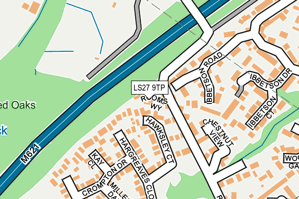
LS27 9TP lies on Rooms Way in Morley, Leeds. LS27 9TP is located in the Morley North electoral ward, within the metropolitan district of Leeds and the English Parliamentary constituency of Morley and Outwood. The Sub Integrated Care Board (ICB) Location is NHS West Yorkshire ICB - 15F and the police force is West Yorkshire. This postcode has been in use since September 2005.


GetTheData
Source: OS OpenMap – Local (Ordnance Survey)
Source: OS VectorMap District (Ordnance Survey)
Licence: Open Government Licence (requires attribution)
| Easting | 426013 |
| Northing | 429129 |
| Latitude | 53.757876 |
| Longitude | -1.606931 |
GetTheData
Source: Open Postcode Geo
Licence: Open Government Licence
| Street | Rooms Way |
| Locality | Morley |
| Town/City | Leeds |
| Country | England |
| Postcode District | LS27 |
➜ See where LS27 is on a map ➜ Where is Morley? | |
GetTheData
Source: Land Registry Price Paid Data
Licence: Open Government Licence
Elevation or altitude of LS27 9TP as distance above sea level:
| Metres | Feet | |
|---|---|---|
| Elevation | 130m | 427ft |
Elevation is measured from the approximate centre of the postcode, to the nearest point on an OS contour line from OS Terrain 50, which has contour spacing of ten vertical metres.
➜ How high above sea level am I? Find the elevation of your current position using your device's GPS.
GetTheData
Source: Open Postcode Elevation
Licence: Open Government Licence
| Ward | Morley North |
| Constituency | Morley And Outwood |
GetTheData
Source: ONS Postcode Database
Licence: Open Government Licence
2016 25 NOV £310,000 |
2013 24 JUN £285,000 |
2005 2 SEP £249,950 |
3, ROOMS WAY, MORLEY, LEEDS, LS27 9TP 2005 26 AUG £349,950 |
1, ROOMS WAY, MORLEY, LEEDS, LS27 9TP 2005 26 AUG £249,950 |
4, ROOMS WAY, MORLEY, LEEDS, LS27 9TP 2005 26 AUG £349,950 |
GetTheData
Source: HM Land Registry Price Paid Data
Licence: Contains HM Land Registry data © Crown copyright and database right 2025. This data is licensed under the Open Government Licence v3.0.
| Ingle Ave Horsfall St (Ingle Avenue) | Morley | 452m |
| Ingle Ave Horsfall St (Ingle Avenue) | Morley | 475m |
| Ingle Ave Ingle Grove (Ingle Avenue) | Morley | 567m |
| Ingle Ave Ingle Grove (Ingle Avenue) | Morley | 573m |
| Horsfall Street Asquith Ave (Horsfall Street) | Morley | 653m |
| Morley Station | 1.4km |
| Cottingley Station | 1.7km |
| Leeds Station | 5.7km |
GetTheData
Source: NaPTAN
Licence: Open Government Licence
| Percentage of properties with Next Generation Access | 100.0% |
| Percentage of properties with Superfast Broadband | 100.0% |
| Percentage of properties with Ultrafast Broadband | 100.0% |
| Percentage of properties with Full Fibre Broadband | 100.0% |
Superfast Broadband is between 30Mbps and 300Mbps
Ultrafast Broadband is > 300Mbps
| Percentage of properties unable to receive 2Mbps | 0.0% |
| Percentage of properties unable to receive 5Mbps | 0.0% |
| Percentage of properties unable to receive 10Mbps | 0.0% |
| Percentage of properties unable to receive 30Mbps | 0.0% |
GetTheData
Source: Ofcom
Licence: Ofcom Terms of Use (requires attribution)
GetTheData
Source: ONS Postcode Database
Licence: Open Government Licence


➜ Get more ratings from the Food Standards Agency
GetTheData
Source: Food Standards Agency
Licence: FSA terms & conditions
| Last Collection | |||
|---|---|---|---|
| Location | Mon-Fri | Sat | Distance |
| Woodcross Fold | 17:30 | 11:00 | 525m |
| Deanfield Avenue | 17:30 | 11:00 | 622m |
| St Bernards Scrap Yards | 17:45 | 11:00 | 778m |
GetTheData
Source: Dracos
Licence: Creative Commons Attribution-ShareAlike
The below table lists the International Territorial Level (ITL) codes (formerly Nomenclature of Territorial Units for Statistics (NUTS) codes) and Local Administrative Units (LAU) codes for LS27 9TP:
| ITL 1 Code | Name |
|---|---|
| TLE | Yorkshire and The Humber |
| ITL 2 Code | Name |
| TLE4 | West Yorkshire |
| ITL 3 Code | Name |
| TLE42 | Leeds |
| LAU 1 Code | Name |
| E08000035 | Leeds |
GetTheData
Source: ONS Postcode Directory
Licence: Open Government Licence
The below table lists the Census Output Area (OA), Lower Layer Super Output Area (LSOA), and Middle Layer Super Output Area (MSOA) for LS27 9TP:
| Code | Name | |
|---|---|---|
| OA | E00058079 | |
| LSOA | E01011528 | Leeds 095D |
| MSOA | E02002424 | Leeds 095 |
GetTheData
Source: ONS Postcode Directory
Licence: Open Government Licence
| LS27 9TF | Hawksley Court | 66m |
| LS27 7UW | Ibbetson Croft | 71m |
| LS27 9LB | Chestnut View | 109m |
| LS27 9TL | Arkwright Walk | 126m |
| LS27 7UN | Ibbetson Road | 142m |
| LS27 9TG | Kay Close | 143m |
| LS27 9TE | Hargreaves Close | 169m |
| LS27 9TJ | Crompton Drive | 173m |
| LS27 9LN | Chestnut Gardens | 187m |
| LS27 9TQ | Millers Dale | 202m |
GetTheData
Source: Open Postcode Geo; Land Registry Price Paid Data
Licence: Open Government Licence