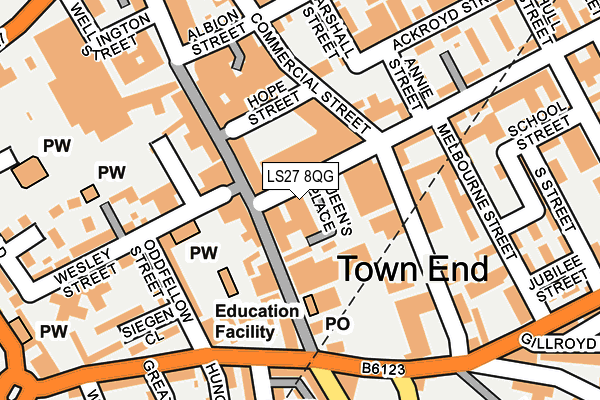
LS27 8QG is located in the Morley South electoral ward, within the metropolitan district of Leeds and the English Parliamentary constituency of Morley and Outwood. The Sub Integrated Care Board (ICB) Location is NHS West Yorkshire ICB - 15F and the police force is West Yorkshire. This postcode has been in use since January 1980.


GetTheData
Source: OS OpenMap – Local (Ordnance Survey)
Source: OS VectorMap District (Ordnance Survey)
Licence: Open Government Licence (requires attribution)
| Easting | 426492 |
| Northing | 427632 |
| Latitude | 53.744413 |
| Longitude | -1.599798 |
GetTheData
Source: Open Postcode Geo
Licence: Open Government Licence
| Country | England |
| Postcode District | LS27 |
| ➜ LS27 open data dashboard ➜ See where LS27 is on a map ➜ Where is Morley? | |
GetTheData
Source: Land Registry Price Paid Data
Licence: Open Government Licence
Elevation or altitude of LS27 8QG as distance above sea level:
| Metres | Feet | |
|---|---|---|
| Elevation | 140m | 459ft |
Elevation is measured from the approximate centre of the postcode, to the nearest point on an OS contour line from OS Terrain 50, which has contour spacing of ten vertical metres.
➜ How high above sea level am I? Find the elevation of your current position using your device's GPS.
GetTheData
Source: Open Postcode Elevation
Licence: Open Government Licence
| Ward | Morley South |
| Constituency | Morley And Outwood |
GetTheData
Source: ONS Postcode Database
Licence: Open Government Licence
| January 2024 | Burglary | On or near Parking Area | 139m |
| December 2023 | Other theft | On or near Parking Area | 139m |
| December 2023 | Violence and sexual offences | On or near Appleby Way | 415m |
| ➜ Get more crime data in our Crime section | |||
GetTheData
Source: data.police.uk
Licence: Open Government Licence
| Commercial Street | Morley | 117m |
| Commercial Street | Morley | 147m |
| Commercial Street Middleton Rd (Commercial Street) | Morley | 171m |
| Fountain Street High St (Fountain Street) | Morley | 185m |
| Town Hall (Queen Street) | Morley | 207m |
| Morley Station | 0.8km |
| Cottingley Station | 2.7km |
| Batley Station | 4.1km |
GetTheData
Source: NaPTAN
Licence: Open Government Licence
GetTheData
Source: ONS Postcode Database
Licence: Open Government Licence


➜ Get more ratings from the Food Standards Agency
GetTheData
Source: Food Standards Agency
Licence: FSA terms & conditions
| Last Collection | |||
|---|---|---|---|
| Location | Mon-Fri | Sat | Distance |
| Morley P.o. | 18:30 | 12:15 | 98m |
| Bridge Court | 17:30 | 12:00 | 599m |
| Corporation Street | 17:30 | 11:15 | 631m |
GetTheData
Source: Dracos
Licence: Creative Commons Attribution-ShareAlike
| Facility | Distance |
|---|---|
| Fusion Fitness Peel Street, Morley Health and Fitness Gym, Studio | 310m |
| Seven Hills Primary School Appleby Way, Morley, Leeds Grass Pitches | 359m |
| Morley Leisure Centre (Closed) Queensway, Morley, Leeds Sports Hall, Studio, Swimming Pool, Health and Fitness Gym, Squash Courts | 428m |
GetTheData
Source: Active Places
Licence: Open Government Licence
| School | Phase of Education | Distance |
|---|---|---|
| Queenswood School Queen Street, Morley, Leeds, LS27 9EB | Not applicable | 77m |
| Seven Hills Primary School Appleby Way, Morley, Leeds, LS27 8LA | Primary | 414m |
| The Morley Academy Fountain Street, Morley, Leeds, LS27 0PD | Secondary | 527m |
GetTheData
Source: Edubase
Licence: Open Government Licence
The below table lists the International Territorial Level (ITL) codes (formerly Nomenclature of Territorial Units for Statistics (NUTS) codes) and Local Administrative Units (LAU) codes for LS27 8QG:
| ITL 1 Code | Name |
|---|---|
| TLE | Yorkshire and The Humber |
| ITL 2 Code | Name |
| TLE4 | West Yorkshire |
| ITL 3 Code | Name |
| TLE42 | Leeds |
| LAU 1 Code | Name |
| E08000035 | Leeds |
GetTheData
Source: ONS Postcode Directory
Licence: Open Government Licence
The below table lists the Census Output Area (OA), Lower Layer Super Output Area (LSOA), and Middle Layer Super Output Area (MSOA) for LS27 8QG:
| Code | Name | |
|---|---|---|
| OA | E00058189 | |
| LSOA | E01011541 | Leeds 104B |
| MSOA | E02002433 | Leeds 104 |
GetTheData
Source: ONS Postcode Directory
Licence: Open Government Licence
| LS27 8HE | Queen Street | 40m |
| LS27 8DW | Queen Street | 72m |
| LS27 9EB | Queen Street | 87m |
| LS27 8HA | Hope Street | 100m |
| LS27 9BP | Queen Street | 117m |
| LS27 8HL | Commercial Street | 121m |
| LS27 8LB | Peel Street | 128m |
| LS27 8AG | Commercial Street | 129m |
| LS27 8QW | Peel Villas | 132m |
| LS27 8AZ | Commercial Street | 137m |
GetTheData
Source: Open Postcode Geo; Land Registry Price Paid Data
Licence: Open Government Licence