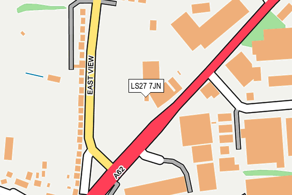
LS27 7JN lies on Gelderd Road in Gildersome, Leeds. LS27 7JN is located in the Morley North electoral ward, within the metropolitan district of Leeds and the English Parliamentary constituency of Morley and Outwood. The Sub Integrated Care Board (ICB) Location is NHS West Yorkshire ICB - 15F and the police force is West Yorkshire. This postcode has been in use since January 1980.


GetTheData
Source: OS OpenMap – Local (Ordnance Survey)
Source: OS VectorMap District (Ordnance Survey)
Licence: Open Government Licence (requires attribution)
| Easting | 424347 |
| Northing | 428491 |
| Latitude | 53.752222 |
| Longitude | -1.632250 |
GetTheData
Source: Open Postcode Geo
Licence: Open Government Licence
| Street | Gelderd Road |
| Locality | Gildersome |
| Town/City | Leeds |
| Country | England |
| Postcode District | LS27 |
| ➜ LS27 open data dashboard ➜ See where LS27 is on a map ➜ Where is Gildersome? | |
GetTheData
Source: Land Registry Price Paid Data
Licence: Open Government Licence
Elevation or altitude of LS27 7JN as distance above sea level:
| Metres | Feet | |
|---|---|---|
| Elevation | 160m | 525ft |
Elevation is measured from the approximate centre of the postcode, to the nearest point on an OS contour line from OS Terrain 50, which has contour spacing of ten vertical metres.
➜ How high above sea level am I? Find the elevation of your current position using your device's GPS.
GetTheData
Source: Open Postcode Elevation
Licence: Open Government Licence
| Ward | Morley North |
| Constituency | Morley And Outwood |
GetTheData
Source: ONS Postcode Database
Licence: Open Government Licence
| April 2023 | Violence and sexual offences | On or near Field Park Grange | 332m |
| April 2023 | Violence and sexual offences | On or near Field Park Grange | 332m |
| April 2023 | Public order | On or near Field Park Grange | 332m |
| ➜ Gelderd Road crime map and outcomes | |||
GetTheData
Source: data.police.uk
Licence: Open Government Licence
| Gildersome Cross Roads (Street Lane) | Gildersome | 125m |
| Gildersome Cross Roads (East View) | Gildersome | 160m |
| Street Ln Briarfield Gdns (Street Lane) | Gildersome | 200m |
| Street Ln Briarfield Gdns (Street Lane) | Gildersome | 278m |
| Gildersome Cross Roads (Wakefield Road) | Gildersome | 384m |
| Morley Station | 2.7km |
| Cottingley Station | 3.4km |
| Batley Station | 4.7km |
GetTheData
Source: NaPTAN
Licence: Open Government Licence
Estimated total energy consumption in LS27 7JN by fuel type, 2015.
| Consumption (kWh) | 269,916 |
|---|---|
| Meter count | 6 |
| Mean (kWh/meter) | 44,986 |
| Median (kWh/meter) | 45,473 |
GetTheData
Source: Postcode level gas estimates: 2015 (experimental)
Source: Postcode level electricity estimates: 2015 (experimental)
Licence: Open Government Licence
GetTheData
Source: ONS Postcode Database
Licence: Open Government Licence


➜ Get more ratings from the Food Standards Agency
GetTheData
Source: Food Standards Agency
Licence: FSA terms & conditions
| Last Collection | |||
|---|---|---|---|
| Location | Mon-Fri | Sat | Distance |
| Street Lane | 17:30 | 11:15 | 163m |
| Gildersome Spur/Thistle Way | 18:30 | 515m | |
| Gildersome P.o. | 17:30 | 11:45 | 594m |
GetTheData
Source: Dracos
Licence: Creative Commons Attribution-ShareAlike
| Facility | Distance |
|---|---|
| Street Lane Recreation Ground East View, Gildersome, Morley, Leeds Grass Pitches | 109m |
| Gildersome Sports Club Street Lane, Gildersome, Morley, Leeds Grass Pitches | 200m |
| Birchfield Primary School Birchfield Avenue, Gildersome, Morley, Leeds Grass Pitches, Sports Hall | 451m |
GetTheData
Source: Active Places
Licence: Open Government Licence
| School | Phase of Education | Distance |
|---|---|---|
| Birchfield Primary School Birchfield Avenue, Gildersome, Leeds, LS27 7HU | Primary | 451m |
| Gildersome Primary School Town Street, Gildersome, Leeds, LS27 7AB | Primary | 628m |
| Bruntcliffe Academy Bruntcliffe Lane, Morley, Leeds, LS27 0LZ | Secondary | 1.1km |
GetTheData
Source: Edubase
Licence: Open Government Licence
The below table lists the International Territorial Level (ITL) codes (formerly Nomenclature of Territorial Units for Statistics (NUTS) codes) and Local Administrative Units (LAU) codes for LS27 7JN:
| ITL 1 Code | Name |
|---|---|
| TLE | Yorkshire and The Humber |
| ITL 2 Code | Name |
| TLE4 | West Yorkshire |
| ITL 3 Code | Name |
| TLE42 | Leeds |
| LAU 1 Code | Name |
| E08000035 | Leeds |
GetTheData
Source: ONS Postcode Directory
Licence: Open Government Licence
The below table lists the Census Output Area (OA), Lower Layer Super Output Area (LSOA), and Middle Layer Super Output Area (MSOA) for LS27 7JN:
| Code | Name | |
|---|---|---|
| OA | E00170598 | |
| LSOA | E01011523 | Leeds 096C |
| MSOA | E02002425 | Leeds 096 |
GetTheData
Source: ONS Postcode Directory
Licence: Open Government Licence
| LS27 7JP | Gelderd Road | 130m |
| LS27 7HP | East View | 134m |
| LS27 7JU | Treefield Industrial Estate | 211m |
| LS27 7HS | Briarfield Gardens | 247m |
| LS27 7GP | Street Lane | 282m |
| LS27 7HW | Bradford Road | 307m |
| LS27 7HT | Street Lane | 308m |
| LS27 7HR | Street Lane | 322m |
| LS27 7DS | Vicarage Avenue | 325m |
| LS27 7DT | Vicarage Avenue | 328m |
GetTheData
Source: Open Postcode Geo; Land Registry Price Paid Data
Licence: Open Government Licence