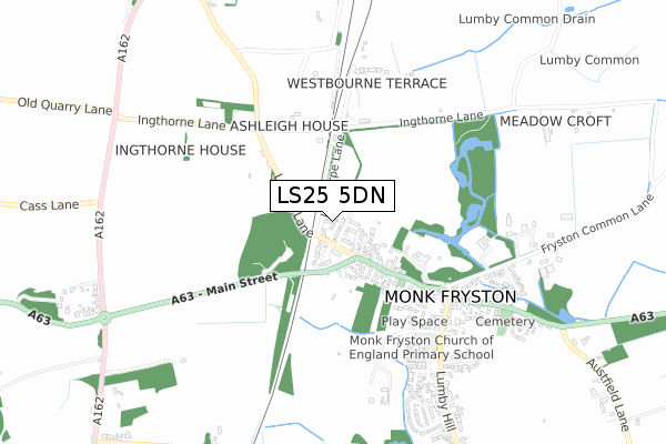
LS25 5DN lies on Ingthorpe Way in Monk Fryston, Leeds. LS25 5DN is located in the Monk Fryston & South Milford electoral ward, within the unitary authority of North Yorkshire and the English Parliamentary constituency of Selby and Ainsty. The Sub Integrated Care Board (ICB) Location is NHS Humber and North Yorkshire ICB - 03Q and the police force is North Yorkshire. This postcode has been in use since March 1988.


GetTheData
Source: OS Open Zoomstack (Ordnance Survey)
Licence: Open Government Licence (requires attribution)
Attribution: Contains OS data © Crown copyright and database right 2025
Source: Open Postcode Geo
Licence: Open Government Licence (requires attribution)
Attribution: Contains OS data © Crown copyright and database right 2025; Contains Royal Mail data © Royal Mail copyright and database right 2025; Source: Office for National Statistics licensed under the Open Government Licence v.3.0
| Easting | 450273 |
| Northing | 429996 |
| Latitude | 53.763897 |
| Longitude | -1.238858 |
GetTheData
Source: Open Postcode Geo
Licence: Open Government Licence
| Street | Ingthorpe Way |
| Locality | Monk Fryston |
| Town/City | Leeds |
| Country | England |
| Postcode District | LS25 |
➜ See where LS25 is on a map ➜ Where is Monk Fryston? | |
GetTheData
Source: Land Registry Price Paid Data
Licence: Open Government Licence
Elevation or altitude of LS25 5DN as distance above sea level:
| Metres | Feet | |
|---|---|---|
| Elevation | 10m | 33ft |
Elevation is measured from the approximate centre of the postcode, to the nearest point on an OS contour line from OS Terrain 50, which has contour spacing of ten vertical metres.
➜ How high above sea level am I? Find the elevation of your current position using your device's GPS.
GetTheData
Source: Open Postcode Elevation
Licence: Open Government Licence
| Ward | Monk Fryston & South Milford |
| Constituency | Selby And Ainsty |
GetTheData
Source: ONS Postcode Database
Licence: Open Government Licence
6, INGTHORPE WAY, MONK FRYSTON, LEEDS, LS25 5DN 2022 2 SEP £395,000 |
2016 1 NOV £250,000 |
5, INGTHORPE WAY, MONK FRYSTON, LEEDS, LS25 5DN 2013 4 DEC £190,000 |
2010 1 OCT £235,000 |
3, INGTHORPE WAY, MONK FRYSTON, LEEDS, LS25 5DN 2010 27 JUL £182,500 |
2, INGTHORPE WAY, MONK FRYSTON, LEEDS, LS25 5DN 2006 5 MAY £198,500 |
2, INGTHORPE WAY, MONK FRYSTON, LEEDS, LS25 5DN 2002 15 MAR £110,000 |
2001 10 APR £88,000 |
4, INGTHORPE WAY, MONK FRYSTON, LEEDS, LS25 5DN 1997 3 APR £68,000 |
4, INGTHORPE WAY, MONK FRYSTON, LEEDS, LS25 5DN 1995 22 DEC £75,500 |
GetTheData
Source: HM Land Registry Price Paid Data
Licence: Contains HM Land Registry data © Crown copyright and database right 2025. This data is licensed under the Open Government Licence v3.0.
| Blue Bell (Main Street) | Monk Fryston | 268m |
| Croft Court (Main Street) | Monk Fryston | 292m |
| Ingthorne Lane (Lumby Lane) | Monk Fryston | 330m |
| Ingthorns Lane (Lumby Lane) | Monk Fryston | 342m |
| Square (Main Street) | Monk Fryston | 470m |
| South Milford Station | 2.2km |
| Sherburn-in-Elmet Station | 3.7km |
GetTheData
Source: NaPTAN
Licence: Open Government Licence
| Percentage of properties with Next Generation Access | 100.0% |
| Percentage of properties with Superfast Broadband | 100.0% |
| Percentage of properties with Ultrafast Broadband | 100.0% |
| Percentage of properties with Full Fibre Broadband | 100.0% |
Superfast Broadband is between 30Mbps and 300Mbps
Ultrafast Broadband is > 300Mbps
| Percentage of properties unable to receive 2Mbps | 0.0% |
| Percentage of properties unable to receive 5Mbps | 0.0% |
| Percentage of properties unable to receive 10Mbps | 0.0% |
| Percentage of properties unable to receive 30Mbps | 0.0% |
GetTheData
Source: Ofcom
Licence: Ofcom Terms of Use (requires attribution)
GetTheData
Source: ONS Postcode Database
Licence: Open Government Licence


➜ Get more ratings from the Food Standards Agency
GetTheData
Source: Food Standards Agency
Licence: FSA terms & conditions
| Last Collection | |||
|---|---|---|---|
| Location | Mon-Fri | Sat | Distance |
| Monk Fryston P.o. | 16:15 | 11:00 | 543m |
| Common Lane/Mill Lane | 16:15 | 09:45 | 1,762m |
| South Milford P.o. | 17:30 | 11:00 | 1,792m |
GetTheData
Source: Dracos
Licence: Creative Commons Attribution-ShareAlike
The below table lists the International Territorial Level (ITL) codes (formerly Nomenclature of Territorial Units for Statistics (NUTS) codes) and Local Administrative Units (LAU) codes for LS25 5DN:
| ITL 1 Code | Name |
|---|---|
| TLE | Yorkshire and The Humber |
| ITL 2 Code | Name |
| TLE2 | North Yorkshire |
| ITL 3 Code | Name |
| TLE22 | North Yorkshire CC |
| LAU 1 Code | Name |
| E07000169 | Selby |
GetTheData
Source: ONS Postcode Directory
Licence: Open Government Licence
The below table lists the Census Output Area (OA), Lower Layer Super Output Area (LSOA), and Middle Layer Super Output Area (MSOA) for LS25 5DN:
| Code | Name | |
|---|---|---|
| OA | E00142136 | |
| LSOA | E01027899 | Selby 009D |
| MSOA | E02005817 | Selby 009 |
GetTheData
Source: ONS Postcode Directory
Licence: Open Government Licence
| LS25 5DD | Ingthorpe Lane | 42m |
| LS25 5EZ | Deer Park Court | 66m |
| LS25 5NF | Abbeystone Way | 114m |
| LS25 5DS | Lumby Lane | 115m |
| LS25 5DX | Malvern Mews | 253m |
| LS25 5DU | Main Street | 259m |
| LS25 5DA | Lumby Lane | 315m |
| LS25 5PL | Croft Court | 317m |
| LS25 5DQ | Ingthorne Lane | 393m |
| LS25 5ES | Prebendal Close | 399m |
GetTheData
Source: Open Postcode Geo; Land Registry Price Paid Data
Licence: Open Government Licence