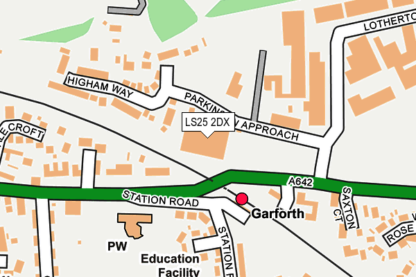
LS25 2DX is located in the Garforth & Swillington electoral ward, within the metropolitan district of Leeds and the English Parliamentary constituency of Elmet and Rothwell. The Sub Integrated Care Board (ICB) Location is NHS West Yorkshire ICB - 15F and the police force is West Yorkshire. This postcode has been in use since February 1990.


GetTheData
Source: OS OpenMap – Local (Ordnance Survey)
Source: OS VectorMap District (Ordnance Survey)
Licence: Open Government Licence (requires attribution)
| Easting | 440730 |
| Northing | 433631 |
| Latitude | 53.797398 |
| Longitude | -1.383132 |
GetTheData
Source: Open Postcode Geo
Licence: Open Government Licence
| Country | England |
| Postcode District | LS25 |
| ➜ LS25 open data dashboard ➜ See where LS25 is on a map ➜ Where is Garforth? | |
GetTheData
Source: Land Registry Price Paid Data
Licence: Open Government Licence
Elevation or altitude of LS25 2DX as distance above sea level:
| Metres | Feet | |
|---|---|---|
| Elevation | 80m | 262ft |
Elevation is measured from the approximate centre of the postcode, to the nearest point on an OS contour line from OS Terrain 50, which has contour spacing of ten vertical metres.
➜ How high above sea level am I? Find the elevation of your current position using your device's GPS.
GetTheData
Source: Open Postcode Elevation
Licence: Open Government Licence
| Ward | Garforth & Swillington |
| Constituency | Elmet And Rothwell |
GetTheData
Source: ONS Postcode Database
Licence: Open Government Licence
| October 2023 | Shoplifting | On or near Parking Area | 458m |
| October 2023 | Criminal damage and arson | On or near Parking Area | 458m |
| October 2023 | Shoplifting | On or near Parking Area | 458m |
| ➜ Get more crime data in our Crime section | |||
GetTheData
Source: data.police.uk
Licence: Open Government Licence
| Aberford Rd Saxton Court (Aberford Road) | Garforth | 105m |
| Aberford Road Beaconsfield Court (Aberford Road) | Garforth | 143m |
| Aberford Rd Saxton Court (Aberford Road) | Garforth | 268m |
| St Benedicts School (Oak Drive) | Garforth | 291m |
| Barrowby Ln Barwick Road (Barrowby Lane) | Garforth | 360m |
| Garforth Station | 0.1km |
| East Garforth Station | 1km |
| Micklefield Station | 3.8km |
GetTheData
Source: NaPTAN
Licence: Open Government Licence
GetTheData
Source: ONS Postcode Database
Licence: Open Government Licence


➜ Get more ratings from the Food Standards Agency
GetTheData
Source: Food Standards Agency
Licence: FSA terms & conditions
| Last Collection | |||
|---|---|---|---|
| Location | Mon-Fri | Sat | Distance |
| Church Lane/Grange Avenue | 17:45 | 10:00 | 552m |
| Garforth P.o. | 18:00 | 11:30 | 562m |
| By Police Station Lidgett Lane | 18:00 | 10:15 | 707m |
GetTheData
Source: Dracos
Licence: Creative Commons Attribution-ShareAlike
| Facility | Distance |
|---|---|
| St Benedict's Catholic Primary School Garforth Station Fields, Garforth, Leeds Grass Pitches, Sports Hall | 234m |
| Garforth Cricket Club Church Lane, Garforth, Leeds Grass Pitches | 530m |
| Ash Lane Recreational Ground Ash Lane, Garforth, Leeds Grass Pitches | 628m |
GetTheData
Source: Active Places
Licence: Open Government Licence
| School | Phase of Education | Distance |
|---|---|---|
| St Benedict's Catholic Primary School Station Fields, Garforth, Leeds, LS25 1PS | Primary | 235m |
| East Garforth Primary Academy Aberford Road, East Garforth, Leeds, LS25 2HF | Primary | 990m |
| Ninelands Primary School Ninelands Lane, Garforth, Leeds, LS25 1NT | Primary | 1km |
GetTheData
Source: Edubase
Licence: Open Government Licence
The below table lists the International Territorial Level (ITL) codes (formerly Nomenclature of Territorial Units for Statistics (NUTS) codes) and Local Administrative Units (LAU) codes for LS25 2DX:
| ITL 1 Code | Name |
|---|---|
| TLE | Yorkshire and The Humber |
| ITL 2 Code | Name |
| TLE4 | West Yorkshire |
| ITL 3 Code | Name |
| TLE42 | Leeds |
| LAU 1 Code | Name |
| E08000035 | Leeds |
GetTheData
Source: ONS Postcode Directory
Licence: Open Government Licence
The below table lists the Census Output Area (OA), Lower Layer Super Output Area (LSOA), and Middle Layer Super Output Area (MSOA) for LS25 2DX:
| Code | Name | |
|---|---|---|
| OA | E00057431 | |
| LSOA | E01011396 | Leeds 074A |
| MSOA | E02002403 | Leeds 074 |
GetTheData
Source: ONS Postcode Directory
Licence: Open Government Licence
| LS25 1PY | Station Road | 112m |
| LS25 2PT | Hanbury Gardens | 135m |
| LS25 2PS | Higham Way | 160m |
| LS25 2QQ | Station Court | 160m |
| LS25 1PT | Station Close | 166m |
| LS25 1PS | Station Fields | 195m |
| LS25 2DH | Sisters Villas | 208m |
| LS25 1PZ | Aberford Road | 211m |
| LS25 1PX | Aberford Road | 212m |
| LS25 2NX | Saxton Court | 231m |
GetTheData
Source: Open Postcode Geo; Land Registry Price Paid Data
Licence: Open Government Licence