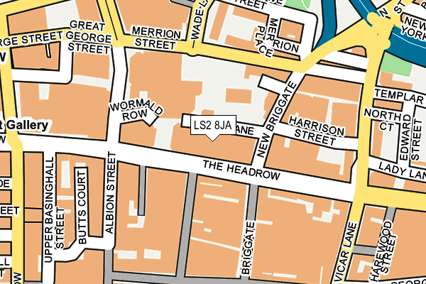
LS2 8JA is located in the Little London & Woodhouse electoral ward, within the metropolitan district of Leeds and the English Parliamentary constituency of Leeds Central. The Sub Integrated Care Board (ICB) Location is NHS West Yorkshire ICB - 15F and the police force is West Yorkshire. This postcode has been in use since January 1980.


GetTheData
Source: OS OpenMap – Local (Ordnance Survey)
Source: OS VectorMap District (Ordnance Survey)
Licence: Open Government Licence (requires attribution)
| Easting | 430209 |
| Northing | 433790 |
| Latitude | 53.799558 |
| Longitude | -1.542841 |
GetTheData
Source: Open Postcode Geo
Licence: Open Government Licence
| Country | England |
| Postcode District | LS2 |
| ➜ LS2 open data dashboard ➜ See where LS2 is on a map ➜ Where is Leeds? | |
GetTheData
Source: Land Registry Price Paid Data
Licence: Open Government Licence
Elevation or altitude of LS2 8JA as distance above sea level:
| Metres | Feet | |
|---|---|---|
| Elevation | 50m | 164ft |
Elevation is measured from the approximate centre of the postcode, to the nearest point on an OS contour line from OS Terrain 50, which has contour spacing of ten vertical metres.
➜ How high above sea level am I? Find the elevation of your current position using your device's GPS.
GetTheData
Source: Open Postcode Elevation
Licence: Open Government Licence
| Ward | Little London & Woodhouse |
| Constituency | Leeds Central |
GetTheData
Source: ONS Postcode Database
Licence: Open Government Licence
| January 2024 | Anti-social behaviour | On or near Parking Area | 270m |
| January 2024 | Bicycle theft | On or near Parking Area | 270m |
| January 2024 | Burglary | On or near Parking Area | 270m |
| ➜ Get more crime data in our Crime section | |||
GetTheData
Source: data.police.uk
Licence: Open Government Licence
| The Headrow | Leeds City Centre | 28m |
| The Headrow | Leeds City Centre | 35m |
| The Headrow | Leeds City Centre | 46m |
| The Headrow | Leeds City Centre | 53m |
| New Briggate | Leeds City Centre | 62m |
| Leeds Station | 0.6km |
| Burley Park Station | 2.7km |
| Headingley Station | 4km |
GetTheData
Source: NaPTAN
Licence: Open Government Licence
GetTheData
Source: ONS Postcode Database
Licence: Open Government Licence


➜ Get more ratings from the Food Standards Agency
GetTheData
Source: Food Standards Agency
Licence: FSA terms & conditions
| Last Collection | |||
|---|---|---|---|
| Location | Mon-Fri | Sat | Distance |
| Dortmund Square | 18:30 | 12:30 | 80m |
| Dortmund Square | 18:30 | 12:30 | 80m |
| The Headrow (Double Box) | 18:30 | 12:30 | 143m |
GetTheData
Source: Dracos
Licence: Creative Commons Attribution-ShareAlike
| Facility | Distance |
|---|---|
| The Gym Group (Leeds Headrow) The Headrow, Leeds Health and Fitness Gym | 77m |
| Nuffield Health (Leeds) The Headrow, Leeds Swimming Pool, Health and Fitness Gym, Studio | 195m |
| Reviva Health Club For Women (Leeds) (Closed) Vicar Lane, Leeds Studio, Health and Fitness Gym | 246m |
GetTheData
Source: Active Places
Licence: Open Government Licence
| School | Phase of Education | Distance |
|---|---|---|
| Adel Beck Care of: Leeds City Council, Civic Hall, Calverley Street, Leeds, LS1 1UR | Not applicable | 474m |
| Leeds College of Building North Street, Leeds, LS2 7QT | 16 plus | 628m |
| Leeds College of Music 3 Quarry Hill, Leeds, LS2 7PD | Not applicable | 693m |
GetTheData
Source: Edubase
Licence: Open Government Licence
The below table lists the International Territorial Level (ITL) codes (formerly Nomenclature of Territorial Units for Statistics (NUTS) codes) and Local Administrative Units (LAU) codes for LS2 8JA:
| ITL 1 Code | Name |
|---|---|
| TLE | Yorkshire and The Humber |
| ITL 2 Code | Name |
| TLE4 | West Yorkshire |
| ITL 3 Code | Name |
| TLE42 | Leeds |
| LAU 1 Code | Name |
| E08000035 | Leeds |
GetTheData
Source: ONS Postcode Directory
Licence: Open Government Licence
The below table lists the Census Output Area (OA), Lower Layer Super Output Area (LSOA), and Middle Layer Super Output Area (MSOA) for LS2 8JA:
| Code | Name | |
|---|---|---|
| OA | E00169785 | |
| LSOA | E01033010 | Leeds 111B |
| MSOA | E02006875 | Leeds 111 |
GetTheData
Source: ONS Postcode Directory
Licence: Open Government Licence
| LS1 6LR | The Headrow | 53m |
| LS2 8RE | Dortmund Square | 77m |
| LS2 8JD | New Briggate | 109m |
| LS1 6NP | Briggate | 115m |
| LS2 8JE | Merrion Street | 117m |
| LS1 6LZ | King Charles Street | 125m |
| LS1 6LH | Briggate | 137m |
| LS1 6NU | New Briggate | 151m |
| LS1 6PT | The Headrow | 154m |
| LS1 5AP | Albion Street | 183m |
GetTheData
Source: Open Postcode Geo; Land Registry Price Paid Data
Licence: Open Government Licence