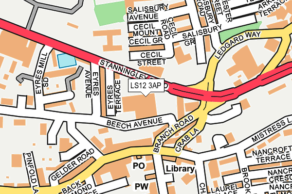
LS12 3AP lies on Stanningley Road in Leeds. LS12 3AP is located in the Armley electoral ward, within the metropolitan district of Leeds and the English Parliamentary constituency of Leeds West. The Sub Integrated Care Board (ICB) Location is NHS West Yorkshire ICB - 15F and the police force is West Yorkshire. This postcode has been in use since January 1980.


GetTheData
Source: OS OpenMap – Local (Ordnance Survey)
Source: OS VectorMap District (Ordnance Survey)
Licence: Open Government Licence (requires attribution)
| Easting | 427176 |
| Northing | 433628 |
| Latitude | 53.798253 |
| Longitude | -1.588898 |
GetTheData
Source: Open Postcode Geo
Licence: Open Government Licence
| Street | Stanningley Road |
| Town/City | Leeds |
| Country | England |
| Postcode District | LS12 |
| ➜ LS12 open data dashboard ➜ See where LS12 is on a map ➜ Where is Leeds? | |
GetTheData
Source: Land Registry Price Paid Data
Licence: Open Government Licence
Elevation or altitude of LS12 3AP as distance above sea level:
| Metres | Feet | |
|---|---|---|
| Elevation | 70m | 230ft |
Elevation is measured from the approximate centre of the postcode, to the nearest point on an OS contour line from OS Terrain 50, which has contour spacing of ten vertical metres.
➜ How high above sea level am I? Find the elevation of your current position using your device's GPS.
GetTheData
Source: Open Postcode Elevation
Licence: Open Government Licence
| Ward | Armley |
| Constituency | Leeds West |
GetTheData
Source: ONS Postcode Database
Licence: Open Government Licence
| December 2023 | Public order | On or near Aviary Row | 386m |
| December 2023 | Public order | On or near Aviary Row | 386m |
| December 2023 | Violence and sexual offences | On or near Aviary Row | 386m |
| ➜ Get more crime data in our Crime section | |||
GetTheData
Source: data.police.uk
Licence: Open Government Licence
| Stanningley Rd Branch Road (Stanningley Road) | Armley | 77m |
| Crab Lane Stocks Hill (Crab Lane) | Armley | 129m |
| Shopping Centre (Town Street) | Armley | 133m |
| Ledgard Way Stanningley Rd (Ledgard Way) | Armley | 141m |
| Shopping Centre (Town Street) | Armley | 164m |
| Burley Park Station | 1.7km |
| Headingley Station | 2.2km |
| Leeds Station | 2.7km |
GetTheData
Source: NaPTAN
Licence: Open Government Licence
GetTheData
Source: ONS Postcode Database
Licence: Open Government Licence


➜ Get more ratings from the Food Standards Agency
GetTheData
Source: Food Standards Agency
Licence: FSA terms & conditions
| Last Collection | |||
|---|---|---|---|
| Location | Mon-Fri | Sat | Distance |
| Armley Lodge Road | 17:30 | 12:15 | 198m |
| Town Street, Armley | 18:30 | 12:15 | 200m |
| Pickering Street/Canal Road | 17:30 | 12:15 | 490m |
GetTheData
Source: Dracos
Licence: Creative Commons Attribution-ShareAlike
| Facility | Distance |
|---|---|
| Armley Squash Club (Closed) Eyres Avenue, Leeds Health and Fitness Gym, Squash Courts | 178m |
| Armley Sports & Leisure Centre (Closed) Carr Crofts, Leeds Sports Hall, Swimming Pool, Health and Fitness Gym, Studio, Squash Courts | 364m |
| Ley Lane Recreation Ground Ley Lane, Leeds Grass Pitches | 425m |
GetTheData
Source: Active Places
Licence: Open Government Licence
| School | Phase of Education | Distance |
|---|---|---|
| Armley Park Primary School Salisbury Terrace, Armley, Leeds, LS12 2AY | Primary | 301m |
| Christ Church Upper Armley Church of England Primary School Theaker Lane, Leeds, LS12 3NU | Primary | 517m |
| St Bartholomew's CofE Voluntary Controlled Primary School Strawberry Lane, Tong Road, St Bartholomews Primary School, Leeds, LS12 1SF | Primary | 520m |
GetTheData
Source: Edubase
Licence: Open Government Licence
The below table lists the International Territorial Level (ITL) codes (formerly Nomenclature of Territorial Units for Statistics (NUTS) codes) and Local Administrative Units (LAU) codes for LS12 3AP:
| ITL 1 Code | Name |
|---|---|
| TLE | Yorkshire and The Humber |
| ITL 2 Code | Name |
| TLE4 | West Yorkshire |
| ITL 3 Code | Name |
| TLE42 | Leeds |
| LAU 1 Code | Name |
| E08000035 | Leeds |
GetTheData
Source: ONS Postcode Directory
Licence: Open Government Licence
The below table lists the Census Output Area (OA), Lower Layer Super Output Area (LSOA), and Middle Layer Super Output Area (MSOA) for LS12 3AP:
| Code | Name | |
|---|---|---|
| OA | E00056882 | |
| LSOA | E01011284 | Leeds 071A |
| MSOA | E02002400 | Leeds 071 |
GetTheData
Source: ONS Postcode Directory
Licence: Open Government Licence
| LS12 2AE | Stanningley Road | 59m |
| LS12 3AY | Eyres Grove | 61m |
| LS12 3AZ | Eyres Street | 70m |
| LS12 3AX | Eyres Terrace | 88m |
| LS12 3BA | Eyres Avenue | 93m |
| LS12 3AQ | Branch Road | 96m |
| LS12 2AL | Cecil Street | 99m |
| LS12 2AW | Cecil Grove | 104m |
| LS12 3AG | Crab Lane | 105m |
| LS12 3LN | Theaker Lane | 113m |
GetTheData
Source: Open Postcode Geo; Land Registry Price Paid Data
Licence: Open Government Licence