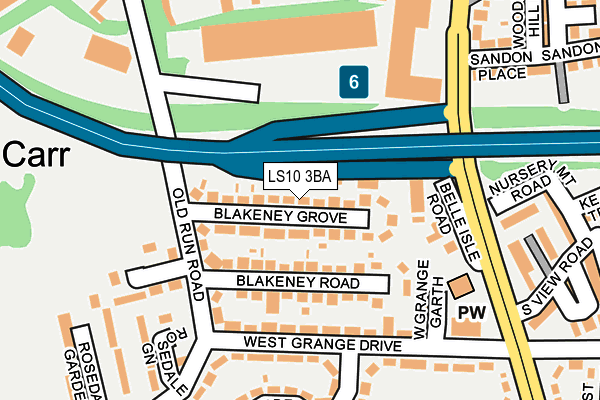
LS10 3BA lies on Blakeney Grove in Leeds. LS10 3BA is located in the Middleton Park electoral ward, within the metropolitan district of Leeds and the English Parliamentary constituency of Leeds Central. The Sub Integrated Care Board (ICB) Location is NHS West Yorkshire ICB - 15F and the police force is West Yorkshire. This postcode has been in use since January 1980.


GetTheData
Source: OS OpenMap – Local (Ordnance Survey)
Source: OS VectorMap District (Ordnance Survey)
Licence: Open Government Licence (requires attribution)
| Easting | 430852 |
| Northing | 430509 |
| Latitude | 53.770016 |
| Longitude | -1.533402 |
GetTheData
Source: Open Postcode Geo
Licence: Open Government Licence
| Street | Blakeney Grove |
| Town/City | Leeds |
| Country | England |
| Postcode District | LS10 |
➜ See where LS10 is on a map ➜ Where is Leeds? | |
GetTheData
Source: Land Registry Price Paid Data
Licence: Open Government Licence
Elevation or altitude of LS10 3BA as distance above sea level:
| Metres | Feet | |
|---|---|---|
| Elevation | 50m | 164ft |
Elevation is measured from the approximate centre of the postcode, to the nearest point on an OS contour line from OS Terrain 50, which has contour spacing of ten vertical metres.
➜ How high above sea level am I? Find the elevation of your current position using your device's GPS.
GetTheData
Source: Open Postcode Elevation
Licence: Open Government Licence
| Ward | Middleton Park |
| Constituency | Leeds Central |
GetTheData
Source: ONS Postcode Database
Licence: Open Government Licence
| Old Run Rd West Grange Drive (Old Run Road) | Hunslet Carr | 141m |
| West Grange Drive | Hunslet Carr | 143m |
| Old Run Rd Belle Isle Road (Old Run Road) | Hunslet Carr | 144m |
| West Grange Drive | Hunslet Carr | 173m |
| West Grange Church (Belle Isle Road) | Hunslet Carr | 205m |
| Leeds Station | 3km |
| Cottingley Station | 3.6km |
| Morley Station | 4.4km |
GetTheData
Source: NaPTAN
Licence: Open Government Licence
| Percentage of properties with Next Generation Access | 100.0% |
| Percentage of properties with Superfast Broadband | 100.0% |
| Percentage of properties with Ultrafast Broadband | 100.0% |
| Percentage of properties with Full Fibre Broadband | 100.0% |
Superfast Broadband is between 30Mbps and 300Mbps
Ultrafast Broadband is > 300Mbps
| Median download speed | 78.1Mbps |
| Average download speed | 69.3Mbps |
| Maximum download speed | 200.00Mbps |
| Median upload speed | 9.8Mbps |
| Average upload speed | 10.7Mbps |
| Maximum upload speed | 20.00Mbps |
| Percentage of properties unable to receive 2Mbps | 0.0% |
| Percentage of properties unable to receive 5Mbps | 0.0% |
| Percentage of properties unable to receive 10Mbps | 0.0% |
| Percentage of properties unable to receive 30Mbps | 0.0% |
GetTheData
Source: Ofcom
Licence: Ofcom Terms of Use (requires attribution)
Estimated total energy consumption in LS10 3BA by fuel type, 2015.
| Consumption (kWh) | 314,368 |
|---|---|
| Meter count | 25 |
| Mean (kWh/meter) | 12,575 |
| Median (kWh/meter) | 12,132 |
| Consumption (kWh) | 94,833 |
|---|---|
| Meter count | 24 |
| Mean (kWh/meter) | 3,951 |
| Median (kWh/meter) | 3,799 |
GetTheData
Source: Postcode level gas estimates: 2015 (experimental)
Source: Postcode level electricity estimates: 2015 (experimental)
Licence: Open Government Licence
GetTheData
Source: ONS Postcode Database
Licence: Open Government Licence


➜ Get more ratings from the Food Standards Agency
GetTheData
Source: Food Standards Agency
Licence: FSA terms & conditions
| Last Collection | |||
|---|---|---|---|
| Location | Mon-Fri | Sat | Distance |
| 29 West Grange Drive/Road | 17:45 | 12:45 | 149m |
| Hunslet Carr | 17:30 | 12:30 | 278m |
| Norwich Avenue | 17:45 | 12:45 | 361m |
GetTheData
Source: Dracos
Licence: Creative Commons Attribution-ShareAlike
The below table lists the International Territorial Level (ITL) codes (formerly Nomenclature of Territorial Units for Statistics (NUTS) codes) and Local Administrative Units (LAU) codes for LS10 3BA:
| ITL 1 Code | Name |
|---|---|
| TLE | Yorkshire and The Humber |
| ITL 2 Code | Name |
| TLE4 | West Yorkshire |
| ITL 3 Code | Name |
| TLE42 | Leeds |
| LAU 1 Code | Name |
| E08000035 | Leeds |
GetTheData
Source: ONS Postcode Directory
Licence: Open Government Licence
The below table lists the Census Output Area (OA), Lower Layer Super Output Area (LSOA), and Middle Layer Super Output Area (MSOA) for LS10 3BA:
| Code | Name | |
|---|---|---|
| OA | E00057797 | |
| LSOA | E01011471 | Leeds 092A |
| MSOA | E02002421 | Leeds 092 |
GetTheData
Source: ONS Postcode Directory
Licence: Open Government Licence
| LS10 3BL | Blakeney Grove | 33m |
| LS10 3BJ | Blakeney Road | 68m |
| LS10 3BH | Blakeney Road | 96m |
| LS10 3AY | West Grange Drive | 139m |
| LS10 2DF | Belle Isle Road | 139m |
| LS10 3BQ | Rosedale Bank | 140m |
| LS10 2DL | Belle Isle Road | 185m |
| LS10 3AZ | Old Run Road | 220m |
| LS10 3BE | Rosedale Walk | 232m |
| LS10 3AT | West Grange Gardens | 233m |
GetTheData
Source: Open Postcode Geo; Land Registry Price Paid Data
Licence: Open Government Licence