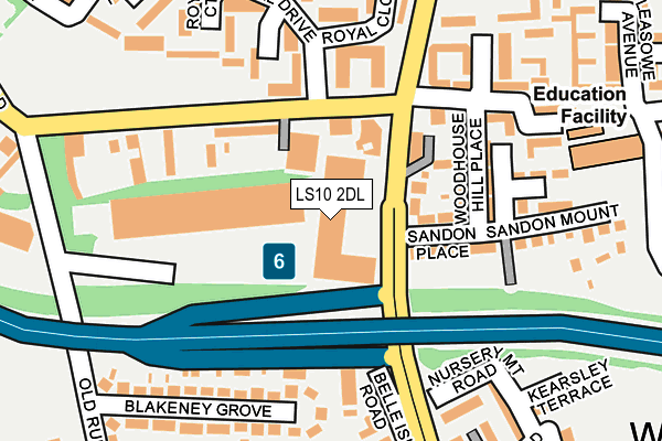
LS10 2DL lies on Belle Isle Road in Leeds. LS10 2DL is located in the Hunslet & Riverside electoral ward, within the metropolitan district of Leeds and the English Parliamentary constituency of Leeds Central. The Sub Integrated Care Board (ICB) Location is NHS West Yorkshire ICB - 15F and the police force is West Yorkshire. This postcode has been in use since February 2005.


GetTheData
Source: OS OpenMap – Local (Ordnance Survey)
Source: OS VectorMap District (Ordnance Survey)
Licence: Open Government Licence (requires attribution)
| Easting | 430953 |
| Northing | 430664 |
| Latitude | 53.771403 |
| Longitude | -1.531854 |
GetTheData
Source: Open Postcode Geo
Licence: Open Government Licence
| Street | Belle Isle Road |
| Town/City | Leeds |
| Country | England |
| Postcode District | LS10 |
➜ See where LS10 is on a map ➜ Where is Leeds? | |
GetTheData
Source: Land Registry Price Paid Data
Licence: Open Government Licence
Elevation or altitude of LS10 2DL as distance above sea level:
| Metres | Feet | |
|---|---|---|
| Elevation | 40m | 131ft |
Elevation is measured from the approximate centre of the postcode, to the nearest point on an OS contour line from OS Terrain 50, which has contour spacing of ten vertical metres.
➜ How high above sea level am I? Find the elevation of your current position using your device's GPS.
GetTheData
Source: Open Postcode Elevation
Licence: Open Government Licence
| Ward | Hunslet & Riverside |
| Constituency | Leeds Central |
GetTheData
Source: ONS Postcode Database
Licence: Open Government Licence
| Balm Rd Moor Road (Balm Road) | Hunslet Carr | 70m |
| Balm Rd Moor Road (Belle Isle Road) | Hunslet Carr | 93m |
| Moor Rd Royal Drive (Moor Road) | Hunslet Carr | 120m |
| Moor Rd Royal Drive (Moor Road) | Hunslet Carr | 143m |
| Balm Road Playfair Rd (Balm Road) | Hunslet Carr | 244m |
| Leeds Station | 2.9km |
| Cottingley Station | 3.7km |
| Morley Station | 4.6km |
GetTheData
Source: NaPTAN
Licence: Open Government Licence
| Percentage of properties with Next Generation Access | 100.0% |
| Percentage of properties with Superfast Broadband | 100.0% |
| Percentage of properties with Ultrafast Broadband | 0.0% |
| Percentage of properties with Full Fibre Broadband | 0.0% |
Superfast Broadband is between 30Mbps and 300Mbps
Ultrafast Broadband is > 300Mbps
| Percentage of properties unable to receive 2Mbps | 0.0% |
| Percentage of properties unable to receive 5Mbps | 0.0% |
| Percentage of properties unable to receive 10Mbps | 0.0% |
| Percentage of properties unable to receive 30Mbps | 0.0% |
GetTheData
Source: Ofcom
Licence: Ofcom Terms of Use (requires attribution)
GetTheData
Source: ONS Postcode Database
Licence: Open Government Licence


➜ Get more ratings from the Food Standards Agency
GetTheData
Source: Food Standards Agency
Licence: FSA terms & conditions
| Last Collection | |||
|---|---|---|---|
| Location | Mon-Fri | Sat | Distance |
| Hunslet Carr | 17:30 | 12:30 | 93m |
| Norwich Avenue | 17:45 | 12:45 | 293m |
| 29 West Grange Drive/Road | 17:45 | 12:45 | 307m |
GetTheData
Source: Dracos
Licence: Creative Commons Attribution-ShareAlike
The below table lists the International Territorial Level (ITL) codes (formerly Nomenclature of Territorial Units for Statistics (NUTS) codes) and Local Administrative Units (LAU) codes for LS10 2DL:
| ITL 1 Code | Name |
|---|---|
| TLE | Yorkshire and The Humber |
| ITL 2 Code | Name |
| TLE4 | West Yorkshire |
| ITL 3 Code | Name |
| TLE42 | Leeds |
| LAU 1 Code | Name |
| E08000035 | Leeds |
GetTheData
Source: ONS Postcode Directory
Licence: Open Government Licence
The below table lists the Census Output Area (OA), Lower Layer Super Output Area (LSOA), and Middle Layer Super Output Area (MSOA) for LS10 2DL:
| Code | Name | |
|---|---|---|
| OA | E00057789 | |
| LSOA | E01011468 | Leeds 112B |
| MSOA | E02006876 | Leeds 112 |
GetTheData
Source: ONS Postcode Directory
Licence: Open Government Licence
| LS10 2DJ | Belle Isle Road | 85m |
| LS10 2DH | Belle Isle Road | 97m |
| LS10 2DQ | Sandon Place | 104m |
| LS10 2JJ | Moor Road | 122m |
| LS10 2DW | Woodhouse Hill Place | 122m |
| LS10 2RR | Royal Gardens | 153m |
| LS10 3BA | Blakeney Grove | 185m |
| LS10 2DF | Belle Isle Road | 186m |
| LS10 2RW | Royal Court | 195m |
| LS10 2RP | Royal Drive | 203m |
GetTheData
Source: Open Postcode Geo; Land Registry Price Paid Data
Licence: Open Government Licence