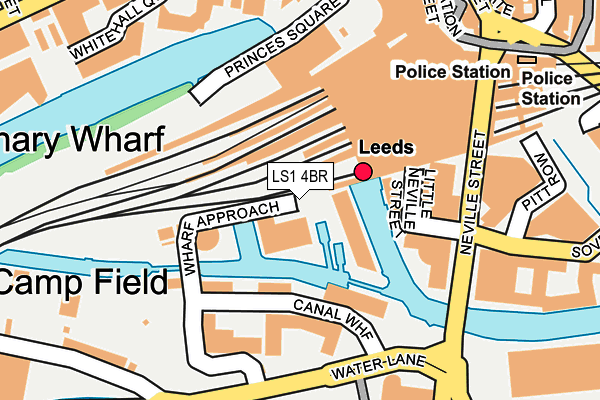
LS1 4BR lies on Granary Wharf in Leeds. LS1 4BR is located in the Beeston & Holbeck electoral ward, within the metropolitan district of Leeds and the English Parliamentary constituency of Leeds Central. The Sub Integrated Care Board (ICB) Location is NHS West Yorkshire ICB - 15F and the police force is West Yorkshire. This postcode has been in use since January 1980.


GetTheData
Source: OS OpenMap – Local (Ordnance Survey)
Source: OS VectorMap District (Ordnance Survey)
Licence: Open Government Licence (requires attribution)
| Easting | 429783 |
| Northing | 433129 |
| Latitude | 53.793626 |
| Longitude | -1.549368 |
GetTheData
Source: Open Postcode Geo
Licence: Open Government Licence
| Street | Granary Wharf |
| Town/City | Leeds |
| Country | England |
| Postcode District | LS1 |
➜ See where LS1 is on a map ➜ Where is Leeds? | |
GetTheData
Source: Land Registry Price Paid Data
Licence: Open Government Licence
Elevation or altitude of LS1 4BR as distance above sea level:
| Metres | Feet | |
|---|---|---|
| Elevation | 30m | 98ft |
Elevation is measured from the approximate centre of the postcode, to the nearest point on an OS contour line from OS Terrain 50, which has contour spacing of ten vertical metres.
➜ How high above sea level am I? Find the elevation of your current position using your device's GPS.
GetTheData
Source: Open Postcode Elevation
Licence: Open Government Licence
| Ward | Beeston & Holbeck |
| Constituency | Leeds Central |
GetTheData
Source: ONS Postcode Database
Licence: Open Government Licence
| Neville Street | Leeds City Centre | 179m |
| Neville Street | Leeds City Centre | 184m |
| Station Interchange (New Station Street) | Leeds City Centre | 217m |
| Rail Replacement (New Station Street) | Leeds City Centre | 228m |
| Station Interchange (New Station Street) | Leeds City Centre | 229m |
| Leeds Station | 0.2km |
| Burley Park Station | 2.8km |
| Cottingley Station | 3.8km |
GetTheData
Source: NaPTAN
Licence: Open Government Licence
GetTheData
Source: ONS Postcode Database
Licence: Open Government Licence


➜ Get more ratings from the Food Standards Agency
GetTheData
Source: Food Standards Agency
Licence: FSA terms & conditions
| Last Collection | |||
|---|---|---|---|
| Location | Mon-Fri | Sat | Distance |
| Leeds City Train Station | 19:00 | 11:30 | 217m |
| Leeds Station North Concourse | 19:00 | 11:30 | 219m |
| Sovereign Street | 18:30 | 11:15 | 222m |
GetTheData
Source: Dracos
Licence: Creative Commons Attribution-ShareAlike
| Risk of LS1 4BR flooding from rivers and sea | Low |
| ➜ LS1 4BR flood map | |
GetTheData
Source: Open Flood Risk by Postcode
Licence: Open Government Licence
The below table lists the International Territorial Level (ITL) codes (formerly Nomenclature of Territorial Units for Statistics (NUTS) codes) and Local Administrative Units (LAU) codes for LS1 4BR:
| ITL 1 Code | Name |
|---|---|
| TLE | Yorkshire and The Humber |
| ITL 2 Code | Name |
| TLE4 | West Yorkshire |
| ITL 3 Code | Name |
| TLE42 | Leeds |
| LAU 1 Code | Name |
| E08000035 | Leeds |
GetTheData
Source: ONS Postcode Directory
Licence: Open Government Licence
The below table lists the Census Output Area (OA), Lower Layer Super Output Area (LSOA), and Middle Layer Super Output Area (MSOA) for LS1 4BR:
| Code | Name | |
|---|---|---|
| OA | E00169811 | |
| LSOA | E01033016 | Leeds 111E |
| MSOA | E02006875 | Leeds 111 |
GetTheData
Source: ONS Postcode Directory
Licence: Open Government Licence
| LS1 4GN | Wharf Approach | 62m |
| LS1 4GQ | Wharf Approach | 62m |
| LS1 4ED | Little Neville Street | 94m |
| LS1 4GH | Wharf Approach | 103m |
| LS1 4GJ | Wharf Approach | 103m |
| LS11 5PS | Canal Wharf | 159m |
| LS1 4BU | Whitehall Quay | 234m |
| LS1 4BW | Whitehall Quay | 234m |
| LS1 4HT | Aire Street | 242m |
| LS11 5QB | Water Lane | 247m |
GetTheData
Source: Open Postcode Geo; Land Registry Price Paid Data
Licence: Open Government Licence