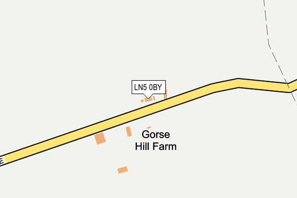
LN5 0BY lies on Gorse Hill Lane in Wellingore, Lincoln. LN5 0BY is located in the Navenby & Brant Broughton electoral ward, within the local authority district of North Kesteven and the English Parliamentary constituency of Sleaford and North Hykeham. The Sub Integrated Care Board (ICB) Location is NHS Lincolnshire ICB - 71E and the police force is Lincolnshire. This postcode has been in use since June 1996.


GetTheData
Source: OS OpenMap – Local (Ordnance Survey)
Source: OS VectorMap District (Ordnance Survey)
Licence: Open Government Licence (requires attribution)
| Easting | 501186 |
| Northing | 356275 |
| Latitude | 53.094124 |
| Longitude | -0.490402 |
GetTheData
Source: Open Postcode Geo
Licence: Open Government Licence
| Street | Gorse Hill Lane |
| Locality | Wellingore |
| Town/City | Lincoln |
| Country | England |
| Postcode District | LN5 |
| ➜ LN5 open data dashboard ➜ See where LN5 is on a map | |
GetTheData
Source: Land Registry Price Paid Data
Licence: Open Government Licence
Elevation or altitude of LN5 0BY as distance above sea level:
| Metres | Feet | |
|---|---|---|
| Elevation | 50m | 164ft |
Elevation is measured from the approximate centre of the postcode, to the nearest point on an OS contour line from OS Terrain 50, which has contour spacing of ten vertical metres.
➜ How high above sea level am I? Find the elevation of your current position using your device's GPS.
GetTheData
Source: Open Postcode Elevation
Licence: Open Government Licence
| Ward | Navenby & Brant Broughton |
| Constituency | Sleaford And North Hykeham |
GetTheData
Source: ONS Postcode Database
Licence: Open Government Licence
| January 2022 | Violence and sexual offences | On or near Gorse Hill Lane | 447m |
| November 2021 | Anti-social behaviour | On or near Gorse Hill Lane | 447m |
| ➜ Gorse Hill Lane crime map and outcomes | |||
GetTheData
Source: data.police.uk
Licence: Open Government Licence
| Percentage of properties with Next Generation Access | 100.0% |
| Percentage of properties with Superfast Broadband | 0.0% |
| Percentage of properties with Ultrafast Broadband | 0.0% |
| Percentage of properties with Full Fibre Broadband | 0.0% |
Superfast Broadband is between 30Mbps and 300Mbps
Ultrafast Broadband is > 300Mbps
| Percentage of properties unable to receive 2Mbps | 0.0% |
| Percentage of properties unable to receive 5Mbps | 100.0% |
| Percentage of properties unable to receive 10Mbps | 100.0% |
| Percentage of properties unable to receive 30Mbps | 100.0% |
GetTheData
Source: Ofcom
Licence: Ofcom Terms of Use (requires attribution)
GetTheData
Source: ONS Postcode Database
Licence: Open Government Licence

➜ Get more ratings from the Food Standards Agency
GetTheData
Source: Food Standards Agency
Licence: FSA terms & conditions
| Last Collection | |||
|---|---|---|---|
| Location | Mon-Fri | Sat | Distance |
| Pottergate Road | 16:15 | 11:00 | 2,563m |
| East Road | 16:30 | 10:45 | 2,592m |
| Navenby | 16:45 | 12:00 | 2,716m |
GetTheData
Source: Dracos
Licence: Creative Commons Attribution-ShareAlike
| Facility | Distance |
|---|---|
| John Cutforth Playing Field Grantham Road, Navenby, Lincoln Grass Pitches | 2.6km |
| Raf Digby Digby, Lincoln Artificial Grass Pitch, Health and Fitness Gym, Grass Pitches, Sports Hall, Outdoor Tennis Courts, Squash Courts | 3.6km |
| Welbourn Playing Field Beck Street, Welbourn, Lincoln Grass Pitches, Outdoor Tennis Courts | 4.8km |
GetTheData
Source: Active Places
Licence: Open Government Licence
| School | Phase of Education | Distance |
|---|---|---|
| Navenby Church of England Primary School East Road, Navenby, Lincoln, LN5 0EP | Primary | 2.7km |
| Digby the Tedder Primary School Trenchard Road, Ashby-De-La-Launde, Lincoln, LN4 3JY | Primary | 3.8km |
| The Welbourn Church of England Primary School High Street, Welbourn, Lincoln, LN5 0NH | Primary | 5km |
GetTheData
Source: Edubase
Licence: Open Government Licence
The below table lists the International Territorial Level (ITL) codes (formerly Nomenclature of Territorial Units for Statistics (NUTS) codes) and Local Administrative Units (LAU) codes for LN5 0BY:
| ITL 1 Code | Name |
|---|---|
| TLF | East Midlands (England) |
| ITL 2 Code | Name |
| TLF3 | Lincolnshire |
| ITL 3 Code | Name |
| TLF30 | Lincolnshire CC |
| LAU 1 Code | Name |
| E07000139 | North Kesteven |
GetTheData
Source: ONS Postcode Directory
Licence: Open Government Licence
The below table lists the Census Output Area (OA), Lower Layer Super Output Area (LSOA), and Middle Layer Super Output Area (MSOA) for LN5 0BY:
| Code | Name | |
|---|---|---|
| OA | E00133011 | |
| LSOA | E01026196 | North Kesteven 006D |
| MSOA | E02005458 | North Kesteven 006 |
GetTheData
Source: ONS Postcode Directory
Licence: Open Government Licence
| LN5 0DA | The Heath | 1048m |
| LN5 0DE | Thompsons Bottom | 1409m |
| LN5 0AY | Heath Lane | 1596m |
| LN4 3JW | Ashby Lodge | 1999m |
| LN5 0TX | Temple Goring | 2168m |
| LN5 0TW | Short Furrow | 2305m |
| LN5 0TT | Heath Road | 2309m |
| LN5 0TR | Headland Way | 2317m |
| LN5 0TF | Winton Road | 2380m |
| LN5 0TP | Hales Lane | 2407m |
GetTheData
Source: Open Postcode Geo; Land Registry Price Paid Data
Licence: Open Government Licence