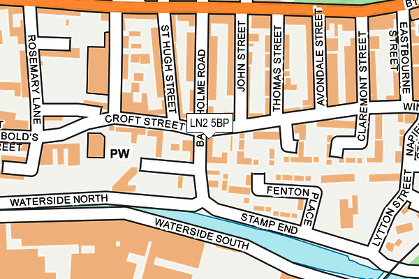
LN2 5BP is located in the Abbey electoral ward, within the local authority district of Lincoln and the English Parliamentary constituency of Lincoln. The Sub Integrated Care Board (ICB) Location is NHS Lincolnshire ICB - 71E and the police force is Lincolnshire. This postcode has been in use since January 1980.


GetTheData
Source: OS OpenMap – Local (Ordnance Survey)
Source: OS VectorMap District (Ordnance Survey)
Licence: Open Government Licence (requires attribution)
| Easting | 498213 |
| Northing | 371223 |
| Latitude | 53.229000 |
| Longitude | -0.530206 |
GetTheData
Source: Open Postcode Geo
Licence: Open Government Licence
| Country | England |
| Postcode District | LN2 |
➜ See where LN2 is on a map ➜ Where is Lincoln? | |
GetTheData
Source: Land Registry Price Paid Data
Licence: Open Government Licence
Elevation or altitude of LN2 5BP as distance above sea level:
| Metres | Feet | |
|---|---|---|
| Elevation | 10m | 33ft |
Elevation is measured from the approximate centre of the postcode, to the nearest point on an OS contour line from OS Terrain 50, which has contour spacing of ten vertical metres.
➜ How high above sea level am I? Find the elevation of your current position using your device's GPS.
GetTheData
Source: Open Postcode Elevation
Licence: Open Government Licence
| Ward | Abbey |
| Constituency | Lincoln |
GetTheData
Source: ONS Postcode Database
Licence: Open Government Licence
| St Hugh Street (Croft Street) | Lincoln | 94m |
| The Steam Hammer Ph (Winn Street) | Lincoln | 114m |
| The Steam Hammer Ph (Winn Street) | Lincoln | 118m |
| Cheviot Street (Monks Road) | Lincoln | 185m |
| Cheviot Street (Monks Road) | Lincoln | 198m |
| Lincoln Central Station | 0.7km |
| Hykeham Station | 6km |
GetTheData
Source: NaPTAN
Licence: Open Government Licence
GetTheData
Source: ONS Postcode Database
Licence: Open Government Licence


➜ Get more ratings from the Food Standards Agency
GetTheData
Source: Food Standards Agency
Licence: FSA terms & conditions
| Last Collection | |||
|---|---|---|---|
| Location | Mon-Fri | Sat | Distance |
| Grafton Street | 17:00 | 12:15 | 482m |
| Lindum Road | 18:30 | 11:45 | 495m |
| Sincil Street Post Office | 19:00 | 12:30 | 560m |
GetTheData
Source: Dracos
Licence: Creative Commons Attribution-ShareAlike
| Risk of LN2 5BP flooding from rivers and sea | Low |
| ➜ LN2 5BP flood map | |
GetTheData
Source: Open Flood Risk by Postcode
Licence: Open Government Licence
The below table lists the International Territorial Level (ITL) codes (formerly Nomenclature of Territorial Units for Statistics (NUTS) codes) and Local Administrative Units (LAU) codes for LN2 5BP:
| ITL 1 Code | Name |
|---|---|
| TLF | East Midlands (England) |
| ITL 2 Code | Name |
| TLF3 | Lincolnshire |
| ITL 3 Code | Name |
| TLF30 | Lincolnshire CC |
| LAU 1 Code | Name |
| E07000138 | Lincoln |
GetTheData
Source: ONS Postcode Directory
Licence: Open Government Licence
The below table lists the Census Output Area (OA), Lower Layer Super Output Area (LSOA), and Middle Layer Super Output Area (MSOA) for LN2 5BP:
| Code | Name | |
|---|---|---|
| OA | E00132652 | |
| LSOA | E01026126 | Lincoln 004D |
| MSOA | E02005445 | Lincoln 004 |
GetTheData
Source: ONS Postcode Directory
Licence: Open Government Licence
| LN2 5EJ | Winn Street | 16m |
| LN2 5EF | Cannon Street | 46m |
| LN2 5EE | Cannon Street | 56m |
| LN2 5EL | Winn Street | 64m |
| LN2 5BQ | Baggholme Road | 98m |
| LN2 5AX | Croft Street | 101m |
| LN2 5BH | John Street | 108m |
| LN2 5BG | St Hugh Street | 112m |
| LN2 5DP | Stamp End | 118m |
| LN2 5BJ | Thomas Street | 129m |
GetTheData
Source: Open Postcode Geo; Land Registry Price Paid Data
Licence: Open Government Licence