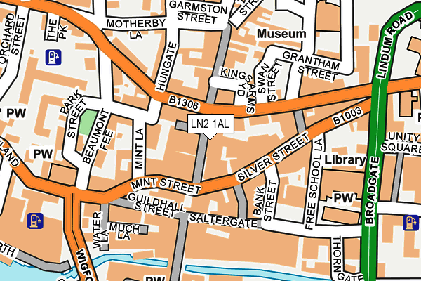
LN2 1AL lies on High Street in Lincoln. LN2 1AL is located in the Abbey electoral ward, within the local authority district of Lincoln and the English Parliamentary constituency of Lincoln. The Sub Integrated Care Board (ICB) Location is NHS Lincolnshire ICB - 71E and the police force is Lincolnshire. This postcode has been in use since January 1980.


GetTheData
Source: OS OpenMap – Local (Ordnance Survey)
Source: OS VectorMap District (Ordnance Survey)
Licence: Open Government Licence (requires attribution)
| Easting | 497563 |
| Northing | 371336 |
| Latitude | 53.230113 |
| Longitude | -0.539905 |
GetTheData
Source: Open Postcode Geo
Licence: Open Government Licence
| Street | High Street |
| Town/City | Lincoln |
| Country | England |
| Postcode District | LN2 |
| ➜ LN2 open data dashboard ➜ See where LN2 is on a map ➜ Where is Lincoln? | |
GetTheData
Source: Land Registry Price Paid Data
Licence: Open Government Licence
Elevation or altitude of LN2 1AL as distance above sea level:
| Metres | Feet | |
|---|---|---|
| Elevation | 10m | 33ft |
Elevation is measured from the approximate centre of the postcode, to the nearest point on an OS contour line from OS Terrain 50, which has contour spacing of ten vertical metres.
➜ How high above sea level am I? Find the elevation of your current position using your device's GPS.
GetTheData
Source: Open Postcode Elevation
Licence: Open Government Licence
| Ward | Abbey |
| Constituency | Lincoln |
GetTheData
Source: ONS Postcode Database
Licence: Open Government Licence
| January 2024 | Anti-social behaviour | On or near Shopping Area | 179m |
| January 2024 | Other theft | On or near Shopping Area | 179m |
| January 2024 | Anti-social behaviour | On or near Parking Area | 299m |
| ➜ High Street crime map and outcomes | |||
GetTheData
Source: data.police.uk
Licence: Open Government Licence
| Stonebow Centre (Silver Street) | Lincoln | 57m |
| Revolution (Hungate) | Lincoln | 88m |
| St Martins Lane | Lincoln | 163m |
| Constitutional Club (Silver Street) | Lincoln | 181m |
| St Swithins's Church (St Swithin's Square) | Lincoln | 202m |
| Lincoln Central Station | 0.4km |
| Hykeham Station | 5.6km |
GetTheData
Source: NaPTAN
Licence: Open Government Licence
GetTheData
Source: ONS Postcode Database
Licence: Open Government Licence


➜ Get more ratings from the Food Standards Agency
GetTheData
Source: Food Standards Agency
Licence: FSA terms & conditions
| Last Collection | |||
|---|---|---|---|
| Location | Mon-Fri | Sat | Distance |
| Corporation Street | 18:30 | 11:30 | 58m |
| Bank Street | 18:30 | 12:45 | 87m |
| Lindum Road | 18:30 | 11:45 | 208m |
GetTheData
Source: Dracos
Licence: Creative Commons Attribution-ShareAlike
| Facility | Distance |
|---|---|
| Base Fitness (Closed) Brayford Wharf North, Lincoln Health and Fitness Gym | 301m |
| Energie Fitness (Lincoln City) (Closed) Sincil Street, Lincoln Health and Fitness Gym | 322m |
| Ymca (Lincolnshire) (Closed) St. Rumbolds Street, Lincoln Health and Fitness Gym, Studio | 436m |
GetTheData
Source: Active Places
Licence: Open Government Licence
| School | Phase of Education | Distance |
|---|---|---|
| Lincolnshire Secure Unit Care of: Lincolnshire County Council, County Offices, Newland, Lincoln, LN1 1YL | Not applicable | 410m |
| Lincoln UTC Lindum Road, Lincoln, LN2 1PF | Secondary | 443m |
| Lincoln College Monks Road, Lincoln, LN2 5HQ | 16 plus | 528m |
GetTheData
Source: Edubase
Licence: Open Government Licence
The below table lists the International Territorial Level (ITL) codes (formerly Nomenclature of Territorial Units for Statistics (NUTS) codes) and Local Administrative Units (LAU) codes for LN2 1AL:
| ITL 1 Code | Name |
|---|---|
| TLF | East Midlands (England) |
| ITL 2 Code | Name |
| TLF3 | Lincolnshire |
| ITL 3 Code | Name |
| TLF30 | Lincolnshire CC |
| LAU 1 Code | Name |
| E07000138 | Lincoln |
GetTheData
Source: ONS Postcode Directory
Licence: Open Government Licence
The below table lists the Census Output Area (OA), Lower Layer Super Output Area (LSOA), and Middle Layer Super Output Area (MSOA) for LN2 1AL:
| Code | Name | |
|---|---|---|
| OA | E00173640 | |
| LSOA | E01026122 | Lincoln 004A |
| MSOA | E02005445 | Lincoln 004 |
GetTheData
Source: ONS Postcode Directory
Licence: Open Government Licence
| LN1 1UF | Park Street | 56m |
| LN2 1DY | Stonebow Centre | 80m |
| LN2 1JL | Kings Arms Yard | 83m |
| LN2 1EH | Silver Street | 83m |
| LN2 1JG | High Street | 89m |
| LN2 1HW | High Street | 105m |
| LN2 1DZ | Bank Street | 122m |
| LN1 1TR | Guildhall Street | 123m |
| LN1 1NL | West Parade | 129m |
| LN2 1LF | Swan Street | 140m |
GetTheData
Source: Open Postcode Geo; Land Registry Price Paid Data
Licence: Open Government Licence