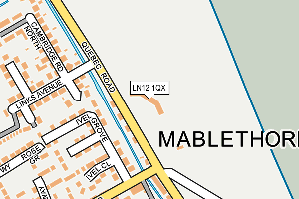
LN12 1QX is located in the Mablethorpe electoral ward, within the local authority district of East Lindsey and the English Parliamentary constituency of Louth and Horncastle. The Sub Integrated Care Board (ICB) Location is NHS Lincolnshire ICB - 71E and the police force is Lincolnshire. This postcode has been in use since January 1980.


GetTheData
Source: OS OpenMap – Local (Ordnance Survey)
Source: OS VectorMap District (Ordnance Survey)
Licence: Open Government Licence (requires attribution)
| Easting | 550273 |
| Northing | 386181 |
| Latitude | 53.351167 |
| Longitude | 0.256189 |
GetTheData
Source: Open Postcode Geo
Licence: Open Government Licence
| Country | England |
| Postcode District | LN12 |
➜ See where LN12 is on a map ➜ Where is Mablethorpe? | |
GetTheData
Source: Land Registry Price Paid Data
Licence: Open Government Licence
Elevation or altitude of LN12 1QX as distance above sea level:
| Metres | Feet | |
|---|---|---|
| Elevation | 10m | 33ft |
Elevation is measured from the approximate centre of the postcode, to the nearest point on an OS contour line from OS Terrain 50, which has contour spacing of ten vertical metres.
➜ How high above sea level am I? Find the elevation of your current position using your device's GPS.
GetTheData
Source: Open Postcode Elevation
Licence: Open Government Licence
| Ward | Mablethorpe |
| Constituency | Louth And Horncastle |
GetTheData
Source: ONS Postcode Database
Licence: Open Government Licence
| Golf Road (Quebec Road) | Mablethorpe | 117m |
| Golf Road (Quebec Road) | Mablethorpe | 121m |
| Links Avenue (Quebec Road) | Mablethorpe | 127m |
| Links Avenue (Quebec Road) | Mablethorpe | 168m |
| Ivel Grove (Golf Road) | Mablethorpe | 179m |
GetTheData
Source: NaPTAN
Licence: Open Government Licence
GetTheData
Source: ONS Postcode Database
Licence: Open Government Licence


➜ Get more ratings from the Food Standards Agency
GetTheData
Source: Food Standards Agency
Licence: FSA terms & conditions
| Last Collection | |||
|---|---|---|---|
| Location | Mon-Fri | Sat | Distance |
| Golf Road | 17:00 | 11:15 | 251m |
| Mablethorpe Post Office | 16:45 | 11:30 | 1,085m |
| The Cross | 16:00 | 09:00 | 2,180m |
GetTheData
Source: Dracos
Licence: Creative Commons Attribution-ShareAlike
| Risk of LN12 1QX flooding from rivers and sea | Low |
| ➜ LN12 1QX flood map | |
GetTheData
Source: Open Flood Risk by Postcode
Licence: Open Government Licence
The below table lists the International Territorial Level (ITL) codes (formerly Nomenclature of Territorial Units for Statistics (NUTS) codes) and Local Administrative Units (LAU) codes for LN12 1QX:
| ITL 1 Code | Name |
|---|---|
| TLF | East Midlands (England) |
| ITL 2 Code | Name |
| TLF3 | Lincolnshire |
| ITL 3 Code | Name |
| TLF30 | Lincolnshire CC |
| LAU 1 Code | Name |
| E07000137 | East Lindsey |
GetTheData
Source: ONS Postcode Directory
Licence: Open Government Licence
The below table lists the Census Output Area (OA), Lower Layer Super Output Area (LSOA), and Middle Layer Super Output Area (MSOA) for LN12 1QX:
| Code | Name | |
|---|---|---|
| OA | E00132336 | |
| LSOA | E01026074 | East Lindsey 005C |
| MSOA | E02005428 | East Lindsey 005 |
GetTheData
Source: ONS Postcode Directory
Licence: Open Government Licence
| LN12 1QT | Lindum Terrace | 67m |
| LN12 1QW | Cambridge Road South | 129m |
| LN12 1LY | Ivel Grove | 134m |
| LN12 1NA | Ivel Close | 192m |
| LN12 1QL | Links Avenue | 210m |
| LN12 1LS | Golf Road | 211m |
| LN12 1LT | Quebec Road | 219m |
| LN12 1QY | Links Close | 224m |
| LN12 1LR | Golf Road | 230m |
| LN12 1QR | Cambridge Road North | 241m |
GetTheData
Source: Open Postcode Geo; Land Registry Price Paid Data
Licence: Open Government Licence