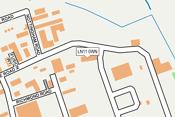
LN11 0WN is located in the North Holme electoral ward, within the local authority district of East Lindsey and the English Parliamentary constituency of Louth and Horncastle. The Sub Integrated Care Board (ICB) Location is NHS Lincolnshire ICB - 71E and the police force is Lincolnshire. This postcode has been in use since February 2008.


GetTheData
Source: OS OpenMap – Local (Ordnance Survey)
Source: OS VectorMap District (Ordnance Survey)
Licence: Open Government Licence (requires attribution)
| Easting | 532768 |
| Northing | 389257 |
| Latitude | 53.383479 |
| Longitude | -0.005324 |
GetTheData
Source: Open Postcode Geo
Licence: Open Government Licence
| Country | England |
| Postcode District | LN11 |
| ➜ LN11 open data dashboard ➜ See where LN11 is on a map ➜ Where is Louth? | |
GetTheData
Source: Land Registry Price Paid Data
Licence: Open Government Licence
Elevation or altitude of LN11 0WN as distance above sea level:
| Metres | Feet | |
|---|---|---|
| Elevation | 30m | 98ft |
Elevation is measured from the approximate centre of the postcode, to the nearest point on an OS contour line from OS Terrain 50, which has contour spacing of ten vertical metres.
➜ How high above sea level am I? Find the elevation of your current position using your device's GPS.
GetTheData
Source: Open Postcode Elevation
Licence: Open Government Licence
| Ward | North Holme |
| Constituency | Louth And Horncastle |
GetTheData
Source: ONS Postcode Database
Licence: Open Government Licence
| June 2022 | Anti-social behaviour | On or near Bennett Road | 423m |
| May 2022 | Vehicle crime | On or near Richmond Road | 226m |
| May 2022 | Other crime | On or near Lincoln Way | 418m |
| ➜ Get more crime data in our Crime section | |||
GetTheData
Source: data.police.uk
Licence: Open Government Licence
| Milford Court (Warwick Road) | Louth | 555m |
| 21 Fulmar Drive (Fulmar Drive) | Louth | 906m |
| 36 Fulmar Drive (Fulmar Drive) | Louth | 914m |
| Brackenborough Road (Jubilee Crescent) | Louth | 945m |
| Lady Of Shallot Ph (Grimsby Road) | Louth | 950m |
GetTheData
Source: NaPTAN
Licence: Open Government Licence
Estimated total energy consumption in LN11 0WN by fuel type, 2015.
| Consumption (kWh) | 63,226 |
|---|---|
| Meter count | 6 |
| Mean (kWh/meter) | 10,538 |
| Median (kWh/meter) | 10,779 |
GetTheData
Source: Postcode level gas estimates: 2015 (experimental)
Source: Postcode level electricity estimates: 2015 (experimental)
Licence: Open Government Licence
GetTheData
Source: ONS Postcode Database
Licence: Open Government Licence


➜ Get more ratings from the Food Standards Agency
GetTheData
Source: Food Standards Agency
Licence: FSA terms & conditions
| Last Collection | |||
|---|---|---|---|
| Location | Mon-Fri | Sat | Distance |
| Brackenborough Road P.o. | 17:00 | 11:15 | 1,102m |
| Newbridge Hill | 17:30 | 11:15 | 1,345m |
| Keddington | 17:00 | 07:00 | 1,529m |
GetTheData
Source: Dracos
Licence: Creative Commons Attribution-ShareAlike
| Facility | Distance |
|---|---|
| Iron Eden Tattershall Way, Fairfield Industrial Estate, Louth Health and Fitness Gym | 365m |
| Louth Tennis And Sports Centre Scarborough Road, Louth Indoor Tennis Centre, Outdoor Tennis Courts | 413m |
| Louth Academy (North Campus) North Holme Road, Louth Grass Pitches, Sports Hall | 1.1km |
GetTheData
Source: Active Places
Licence: Open Government Licence
| School | Phase of Education | Distance |
|---|---|---|
| Greenwich House School 106 High Holme Road, Louth, LN11 0HE | Not applicable | 1.3km |
| Eastfield Infants and Nursery Academy Lacey Gardens, LOUTH, LN11 8DQ | Primary | 2km |
| Lacey Gardens Junior Academy Lacey Gardens, LOUTH, LN11 8DH | Primary | 2km |
GetTheData
Source: Edubase
Licence: Open Government Licence
The below table lists the International Territorial Level (ITL) codes (formerly Nomenclature of Territorial Units for Statistics (NUTS) codes) and Local Administrative Units (LAU) codes for LN11 0WN:
| ITL 1 Code | Name |
|---|---|
| TLF | East Midlands (England) |
| ITL 2 Code | Name |
| TLF3 | Lincolnshire |
| ITL 3 Code | Name |
| TLF30 | Lincolnshire CC |
| LAU 1 Code | Name |
| E07000137 | East Lindsey |
GetTheData
Source: ONS Postcode Directory
Licence: Open Government Licence
The below table lists the Census Output Area (OA), Lower Layer Super Output Area (LSOA), and Middle Layer Super Output Area (MSOA) for LN11 0WN:
| Code | Name | |
|---|---|---|
| OA | E00132364 | |
| LSOA | E01026077 | East Lindsey 003A |
| MSOA | E02005426 | East Lindsey 003 |
GetTheData
Source: ONS Postcode Directory
Licence: Open Government Licence
| LN11 0WA | Bolingbroke Road | 152m |
| LN11 0WB | Nottingham Road | 225m |
| LN11 0NP | Brackenborough Road | 463m |
| LN11 0YB | Warwick Road | 467m |
| LN11 0LQ | Belvoir Way | 545m |
| LN11 0SX | Grimsby Road | 582m |
| LN11 0YZ | Tattershall Way | 597m |
| LN11 0NR | 694m | |
| LN11 0AH | Willow Drive | 713m |
| LN11 0AQ | Brackenborough Road | 743m |
GetTheData
Source: Open Postcode Geo; Land Registry Price Paid Data
Licence: Open Government Licence