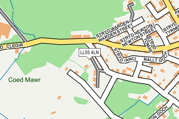
LL55 4LN is located in the Llanberis electoral ward, within the unitary authority of Gwynedd and the Welsh Parliamentary constituency of Arfon. The Local Health Board is Betsi Cadwaladr University and the police force is North Wales. This postcode has been in use since January 1980.


GetTheData
Source: OS OpenMap – Local (Ordnance Survey)
Source: OS VectorMap District (Ordnance Survey)
Licence: Open Government Licence (requires attribution)
| Easting | 257395 |
| Northing | 360328 |
| Latitude | 53.121000 |
| Longitude | -4.132423 |
GetTheData
Source: Open Postcode Geo
Licence: Open Government Licence
| Country | Wales |
| Postcode District | LL55 |
| ➜ LL55 open data dashboard ➜ See where LL55 is on a map ➜ Where is Llanberis? | |
GetTheData
Source: Land Registry Price Paid Data
Licence: Open Government Licence
Elevation or altitude of LL55 4LN as distance above sea level:
| Metres | Feet | |
|---|---|---|
| Elevation | 140m | 459ft |
Elevation is measured from the approximate centre of the postcode, to the nearest point on an OS contour line from OS Terrain 50, which has contour spacing of ten vertical metres.
➜ How high above sea level am I? Find the elevation of your current position using your device's GPS.
GetTheData
Source: Open Postcode Elevation
Licence: Open Government Licence
| Ward | Llanberis |
| Constituency | Arfon |
GetTheData
Source: ONS Postcode Database
Licence: Open Government Licence
| June 2022 | Violence and sexual offences | On or near Stryd Goodman | 166m |
| June 2022 | Criminal damage and arson | On or near Stryd Newton | 182m |
| June 2022 | Anti-social behaviour | On or near Stryd-Y-Dwr | 270m |
| ➜ Get more crime data in our Crime section | |||
GetTheData
Source: data.police.uk
Licence: Open Government Licence
| Hsbc (High Street) | Llanberis | 324m |
| Joe Brown (High Street) | Llanberis | 362m |
| Joe Brown (High Street) | Llanberis | 364m |
| Coed-y-glyn (High Street) | Llanberis | 394m |
| Glyn Rhonwy (Llanberis Road) | Pen-gilfach | 527m |
| Llanberis (Snowdon Mountain Railway) | Llanberis | 1,029m |
GetTheData
Source: NaPTAN
Licence: Open Government Licence
| Percentage of properties with Next Generation Access | 100.0% |
| Percentage of properties with Superfast Broadband | 100.0% |
| Percentage of properties with Ultrafast Broadband | 0.0% |
| Percentage of properties with Full Fibre Broadband | 0.0% |
Superfast Broadband is between 30Mbps and 300Mbps
Ultrafast Broadband is > 300Mbps
| Percentage of properties unable to receive 2Mbps | 0.0% |
| Percentage of properties unable to receive 5Mbps | 0.0% |
| Percentage of properties unable to receive 10Mbps | 0.0% |
| Percentage of properties unable to receive 30Mbps | 0.0% |
GetTheData
Source: Ofcom
Licence: Ofcom Terms of Use (requires attribution)
GetTheData
Source: ONS Postcode Database
Licence: Open Government Licence


➜ Get more ratings from the Food Standards Agency
GetTheData
Source: Food Standards Agency
Licence: FSA terms & conditions
| Last Collection | |||
|---|---|---|---|
| Location | Mon-Fri | Sat | Distance |
| Llanberis Post Office | 17:00 | 11:15 | 327m |
| Ysgol Dolbadarn | 16:45 | 09:30 | 392m |
| Blaenyddol | 11:00 | 11:00 | 970m |
GetTheData
Source: Dracos
Licence: Creative Commons Attribution-ShareAlike
| School | Phase of Education | Distance |
|---|---|---|
| Ysgol Dolbadarn Llanberis, Gwynedd, LL55 4SH | Not applicable | 449m |
| Ysgol Gwaun Gynfi Deiniolen, Gwynedd, LL55 3LT | Not applicable | 3km |
| Ysgol Gymuned Penisarwaun Penisarwaen, Caernarfon, Gwynedd, LL55 3BW | Not applicable | 4km |
GetTheData
Source: Edubase
Licence: Open Government Licence
The below table lists the International Territorial Level (ITL) codes (formerly Nomenclature of Territorial Units for Statistics (NUTS) codes) and Local Administrative Units (LAU) codes for LL55 4LN:
| ITL 1 Code | Name |
|---|---|
| TLL | Wales |
| ITL 2 Code | Name |
| TLL1 | West Wales and The Valleys |
| ITL 3 Code | Name |
| TLL12 | Gwynedd |
| LAU 1 Code | Name |
| W06000002 | Gwynedd |
GetTheData
Source: ONS Postcode Directory
Licence: Open Government Licence
The below table lists the Census Output Area (OA), Lower Layer Super Output Area (LSOA), and Middle Layer Super Output Area (MSOA) for LL55 4LN:
| Code | Name | |
|---|---|---|
| OA | W00000417 | |
| LSOA | W01000081 | Gwynedd 005B |
| MSOA | W02000014 | Gwynedd 005 |
GetTheData
Source: ONS Postcode Directory
Licence: Open Government Licence
| LL55 4LW | Bryn Hyfryd | 25m |
| LL55 4LH | Tydu Road | 59m |
| LL55 4LL | Llainwen Uchaf | 64m |
| LL55 4HT | Cambrian Terrace | 71m |
| LL55 4HS | Olgra Terrace | 80m |
| LL55 4HU | Yankee Street | 92m |
| LL55 4LG | Llainwen Isaf | 107m |
| LL55 4HY | Bryngoleu | 124m |
| LL55 4LA | Rock Terrace | 133m |
| LL55 4HP | Warden Street | 162m |
GetTheData
Source: Open Postcode Geo; Land Registry Price Paid Data
Licence: Open Government Licence