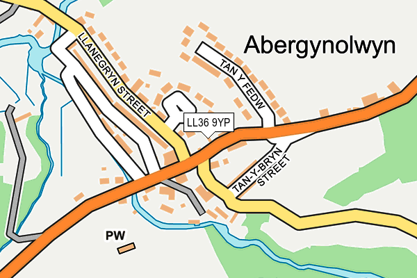
LL36 9YP is in Abergynolwyn, Tywyn. LL36 9YP is located in the Bro Dysynni electoral ward, within the unitary authority of Gwynedd and the Welsh Parliamentary constituency of Dwyfor Meirionnydd. The Local Health Board is Betsi Cadwaladr University and the police force is North Wales. This postcode has been in use since January 1980.


GetTheData
Source: OS OpenMap – Local (Ordnance Survey)
Source: OS VectorMap District (Ordnance Survey)
Licence: Open Government Licence (requires attribution)
| Easting | 267792 |
| Northing | 306999 |
| Latitude | 52.644587 |
| Longitude | -3.955486 |
GetTheData
Source: Open Postcode Geo
Licence: Open Government Licence
| Locality | Abergynolwyn |
| Town/City | Tywyn |
| Country | Wales |
| Postcode District | LL36 |
| ➜ LL36 open data dashboard ➜ See where LL36 is on a map ➜ Where is Abergynolwyn? | |
GetTheData
Source: Land Registry Price Paid Data
Licence: Open Government Licence
Elevation or altitude of LL36 9YP as distance above sea level:
| Metres | Feet | |
|---|---|---|
| Elevation | 40m | 131ft |
Elevation is measured from the approximate centre of the postcode, to the nearest point on an OS contour line from OS Terrain 50, which has contour spacing of ten vertical metres.
➜ How high above sea level am I? Find the elevation of your current position using your device's GPS.
GetTheData
Source: Open Postcode Elevation
Licence: Open Government Licence
| Ward | Bro Dysynni |
| Constituency | Dwyfor Meirionnydd |
GetTheData
Source: ONS Postcode Database
Licence: Open Government Licence
| June 2022 | Other theft | On or near Parking Area | 67m |
| June 2022 | Violence and sexual offences | On or near Tan Y Fedw | 81m |
| March 2022 | Violence and sexual offences | On or near Parking Area | 67m |
| ➜ Get more crime data in our Crime section | |||
GetTheData
Source: data.police.uk
Licence: Open Government Licence
| Railway Inn (B4405) | Abergynolwyn | 81m |
| Railway Inn (B4405) | Abergynolwyn | 90m |
| Railway Station (B4405) | Abergynolwyn | 752m |
| Railway Station (B4405) | Abergynolwyn | 813m |
| Abergynolwyn (Talyllyn Railway) | Abergynolwyn | 963m |
GetTheData
Source: NaPTAN
Licence: Open Government Licence
| Percentage of properties with Next Generation Access | 100.0% |
| Percentage of properties with Superfast Broadband | 100.0% |
| Percentage of properties with Ultrafast Broadband | 0.0% |
| Percentage of properties with Full Fibre Broadband | 0.0% |
Superfast Broadband is between 30Mbps and 300Mbps
Ultrafast Broadband is > 300Mbps
| Percentage of properties unable to receive 2Mbps | 0.0% |
| Percentage of properties unable to receive 5Mbps | 0.0% |
| Percentage of properties unable to receive 10Mbps | 0.0% |
| Percentage of properties unable to receive 30Mbps | 0.0% |
GetTheData
Source: Ofcom
Licence: Ofcom Terms of Use (requires attribution)
GetTheData
Source: ONS Postcode Database
Licence: Open Government Licence

➜ Get more ratings from the Food Standards Agency
GetTheData
Source: Food Standards Agency
Licence: FSA terms & conditions
| Last Collection | |||
|---|---|---|---|
| Location | Mon-Fri | Sat | Distance |
| Abergynolwyn Box | 16:45 | 10:45 | 53m |
| Dolgoch | 10:30 | 10:30 | 3,701m |
| Tal Y Llyn Church | 10:30 | 10:30 | 4,049m |
GetTheData
Source: Dracos
Licence: Creative Commons Attribution-ShareAlike
The below table lists the International Territorial Level (ITL) codes (formerly Nomenclature of Territorial Units for Statistics (NUTS) codes) and Local Administrative Units (LAU) codes for LL36 9YP:
| ITL 1 Code | Name |
|---|---|
| TLL | Wales |
| ITL 2 Code | Name |
| TLL1 | West Wales and The Valleys |
| ITL 3 Code | Name |
| TLL12 | Gwynedd |
| LAU 1 Code | Name |
| W06000002 | Gwynedd |
GetTheData
Source: ONS Postcode Directory
Licence: Open Government Licence
The below table lists the Census Output Area (OA), Lower Layer Super Output Area (LSOA), and Middle Layer Super Output Area (MSOA) for LL36 9YP:
| Code | Name | |
|---|---|---|
| OA | W00000292 | |
| LSOA | W01001933 | Gwynedd 017F |
| MSOA | W02000026 | Gwynedd 017 |
GetTheData
Source: ONS Postcode Directory
Licence: Open Government Licence
| LL36 9YL | Llanegryn Street | 56m |
| LL36 9YH | Bron Y Gader | 64m |
| LL36 9UY | Tan Y Bryn Street | 69m |
| LL36 9YA | Tan Y Bryn Street | 84m |
| LL36 9UU | 118m | |
| LL36 9YU | Tan Y Fedw | 141m |
| LL36 9YG | Egryn Cottages | 144m |
| LL36 9YE | Llanegryn Street | 166m |
| LL36 9YB | Water Street | 177m |
| LL36 9UT | 183m |
GetTheData
Source: Open Postcode Geo; Land Registry Price Paid Data
Licence: Open Government Licence