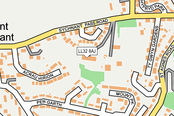
LL32 8AJ is located in the Conwy electoral ward, within the unitary authority of Conwy and the Welsh Parliamentary constituency of Aberconwy. The Local Health Board is Betsi Cadwaladr University and the police force is North Wales. This postcode has been in use since January 1980.


GetTheData
Source: OS OpenMap – Local (Ordnance Survey)
Source: OS VectorMap District (Ordnance Survey)
Licence: Open Government Licence (requires attribution)
| Easting | 277481 |
| Northing | 377310 |
| Latitude | 53.278568 |
| Longitude | -3.838978 |
GetTheData
Source: Open Postcode Geo
Licence: Open Government Licence
| Country | Wales |
| Postcode District | LL32 |
| ➜ LL32 open data dashboard ➜ See where LL32 is on a map ➜ Where is Conwy? | |
GetTheData
Source: Land Registry Price Paid Data
Licence: Open Government Licence
Elevation or altitude of LL32 8AJ as distance above sea level:
| Metres | Feet | |
|---|---|---|
| Elevation | 70m | 230ft |
Elevation is measured from the approximate centre of the postcode, to the nearest point on an OS contour line from OS Terrain 50, which has contour spacing of ten vertical metres.
➜ How high above sea level am I? Find the elevation of your current position using your device's GPS.
GetTheData
Source: Open Postcode Elevation
Licence: Open Government Licence
| Ward | Conwy |
| Constituency | Aberconwy |
GetTheData
Source: ONS Postcode Database
Licence: Open Government Licence
| June 2022 | Criminal damage and arson | On or near Maes Gweryl | 357m |
| June 2022 | Violence and sexual offences | On or near Maes Gweryl | 357m |
| June 2022 | Violence and sexual offences | On or near Parc Sychnant | 370m |
| ➜ Get more crime data in our Crime section | |||
GetTheData
Source: data.police.uk
Licence: Open Government Licence
| Yha (Sychnant Pass Road) | Mount Pleasant | 153m |
| Pengarth Middle (Pen Garth) | Mount Pleasant | 184m |
| Pengarth Middle (Pen Garth) | Mount Pleasant | 192m |
| Pengarth West (Pen Garth) | Mount Pleasant | 255m |
| Pengarth East (Pen Garth) | Mount Pleasant | 260m |
| Conwy Station | 0.6km |
| Deganwy Station | 1.8km |
| Llandudno Junction Station | 2.1km |
GetTheData
Source: NaPTAN
Licence: Open Government Licence
GetTheData
Source: ONS Postcode Database
Licence: Open Government Licence


➜ Get more ratings from the Food Standards Agency
GetTheData
Source: Food Standards Agency
Licence: FSA terms & conditions
| Last Collection | |||
|---|---|---|---|
| Location | Mon-Fri | Sat | Distance |
| Conwy Post Office | 17:05 | 11:45 | 620m |
| Castle Street | 17:15 | 12:15 | 814m |
| Tesco Llandudno Junction | 17:20 | 11:30 | 1,782m |
GetTheData
Source: Dracos
Licence: Creative Commons Attribution-ShareAlike
| School | Phase of Education | Distance |
|---|---|---|
| Ysgol Porth y Felin Ffordd Llanrwst, Conwy, LL32 8FZ | Not applicable | 394m |
| Ysgol Aberconwy Morfa Drive, Conwy, LL32 8ED | Not applicable | 924m |
| Ysgol Deganwy Park Drive, Deganwy, Conwy, LL31 9YB | Not applicable | 2km |
GetTheData
Source: Edubase
Licence: Open Government Licence
The below table lists the International Territorial Level (ITL) codes (formerly Nomenclature of Territorial Units for Statistics (NUTS) codes) and Local Administrative Units (LAU) codes for LL32 8AJ:
| ITL 1 Code | Name |
|---|---|
| TLL | Wales |
| ITL 2 Code | Name |
| TLL1 | West Wales and The Valleys |
| ITL 3 Code | Name |
| TLL13 | Conwy and Denbighshire |
| LAU 1 Code | Name |
| W06000003 | Conwy |
GetTheData
Source: ONS Postcode Directory
Licence: Open Government Licence
The below table lists the Census Output Area (OA), Lower Layer Super Output Area (LSOA), and Middle Layer Super Output Area (MSOA) for LL32 8AJ:
| Code | Name | |
|---|---|---|
| OA | W00000693 | |
| LSOA | W01000131 | Conwy 012D |
| MSOA | W02000038 | Conwy 012 |
GetTheData
Source: ONS Postcode Directory
Licence: Open Government Licence
| LL32 8RD | Rhodfa Sychnant | 91m |
| LL32 8RP | Pengarth | 171m |
| LL32 8SA | Jubilee Terrace | 190m |
| LL32 8RW | Pengarth | 200m |
| LL32 8RN | Mount Park | 200m |
| LL32 8RE | Sychnant Pass Road | 226m |
| LL32 8RY | St Agnes Road | 239m |
| LL32 8RA | Ty Gwyn Gardens | 253m |
| LL32 8RS | Gorlan | 277m |
| LL32 8RT | Gorlan | 292m |
GetTheData
Source: Open Postcode Geo; Land Registry Price Paid Data
Licence: Open Government Licence