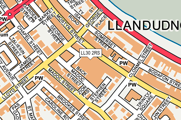
LL30 2RS is located in the Gogarth Mostyn electoral ward, within the unitary authority of Conwy and the Welsh Parliamentary constituency of Aberconwy. The Local Health Board is Betsi Cadwaladr University and the police force is North Wales. This postcode has been in use since July 1995.


GetTheData
Source: OS OpenMap – Local (Ordnance Survey)
Source: OS VectorMap District (Ordnance Survey)
Licence: Open Government Licence (requires attribution)
| Easting | 278256 |
| Northing | 382300 |
| Latitude | 53.323577 |
| Longitude | -3.829277 |
GetTheData
Source: Open Postcode Geo
Licence: Open Government Licence
| Country | Wales |
| Postcode District | LL30 |
| ➜ LL30 open data dashboard ➜ See where LL30 is on a map ➜ Where is Llandudno? | |
GetTheData
Source: Land Registry Price Paid Data
Licence: Open Government Licence
Elevation or altitude of LL30 2RS as distance above sea level:
| Metres | Feet | |
|---|---|---|
| Elevation | 10m | 33ft |
Elevation is measured from the approximate centre of the postcode, to the nearest point on an OS contour line from OS Terrain 50, which has contour spacing of ten vertical metres.
➜ How high above sea level am I? Find the elevation of your current position using your device's GPS.
GetTheData
Source: Open Postcode Elevation
Licence: Open Government Licence
| Ward | Gogarth Mostyn |
| Constituency | Aberconwy |
GetTheData
Source: ONS Postcode Database
Licence: Open Government Licence
| January 2024 | Anti-social behaviour | On or near Parking Area | 32m |
| January 2024 | Public order | On or near Parking Area | 32m |
| January 2024 | Shoplifting | On or near Parking Area | 32m |
| ➜ Get more crime data in our Crime section | |||
GetTheData
Source: data.police.uk
Licence: Open Government Licence
| Marks & Spencers (Mostyn Street) | Llandudno | 40m |
| Victoria Centre (Mostyn Street) | Llandudno | 99m |
| Lloyd Street | Llandudno | 107m |
| Town Hall (Lloyd Street) | Llandudno | 121m |
| Trinity Square | Llandudno | 132m |
| Victoria Station (Great Orme Tramway) | Llandudno | 583m |
| Llandudno Station | 0.3km |
| Deganwy Station | 3.2km |
| Llandudno Junction Station | 4.6km |
GetTheData
Source: NaPTAN
Licence: Open Government Licence
GetTheData
Source: ONS Postcode Database
Licence: Open Government Licence


➜ Get more ratings from the Food Standards Agency
GetTheData
Source: Food Standards Agency
Licence: FSA terms & conditions
| Last Collection | |||
|---|---|---|---|
| Location | Mon-Fri | Sat | Distance |
| Mostyn Street Post Office | 17:10 | 11:30 | 37m |
| St Georges Crescent | 17:15 | 11:30 | 182m |
| Gloddaeth Street Box | 17:05 | 11:30 | 274m |
GetTheData
Source: Dracos
Licence: Creative Commons Attribution-ShareAlike
| School | Phase of Education | Distance |
|---|---|---|
| Ysgol Tudno Trinity Avenue, Llandudno, LL30 2SJ | Not applicable | 426m |
| Ysgol John Bright Maesdu Road, Llandudno, LL30 1DF | Not applicable | 428m |
| Ysgol San Sior Church Walks, Llandudno, Conwy, LL30 2HL | Not applicable | 745m |
GetTheData
Source: Edubase
Licence: Open Government Licence
The below table lists the International Territorial Level (ITL) codes (formerly Nomenclature of Territorial Units for Statistics (NUTS) codes) and Local Administrative Units (LAU) codes for LL30 2RS:
| ITL 1 Code | Name |
|---|---|
| TLL | Wales |
| ITL 2 Code | Name |
| TLL1 | West Wales and The Valleys |
| ITL 3 Code | Name |
| TLL13 | Conwy and Denbighshire |
| LAU 1 Code | Name |
| W06000003 | Conwy |
GetTheData
Source: ONS Postcode Directory
Licence: Open Government Licence
The below table lists the Census Output Area (OA), Lower Layer Super Output Area (LSOA), and Middle Layer Super Output Area (MSOA) for LL30 2RS:
| Code | Name | |
|---|---|---|
| OA | W00000894 | |
| LSOA | W01000169 | Conwy 001D |
| MSOA | W02000027 | Conwy 001 |
GetTheData
Source: ONS Postcode Directory
Licence: Open Government Licence
| LL30 2RP | Mostyn Street | 0m |
| LL30 2NN | Mostyn Street | 58m |
| LL30 2TE | Back Madoc Street | 95m |
| LL30 2TL | Madoc Street | 100m |
| LL30 2UU | Lloyd Street | 107m |
| LL30 2RH | Trinity Square | 113m |
| LL30 2LH | Somerset Street | 116m |
| LL30 2NR | St Georges Place | 124m |
| LL30 2RD | Trinity Square | 137m |
| LL30 2LE | Clonmel Street | 139m |
GetTheData
Source: Open Postcode Geo; Land Registry Price Paid Data
Licence: Open Government Licence