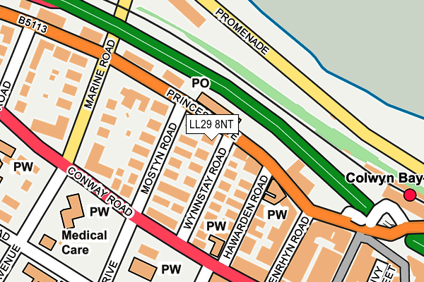
LL29 8NT is located in the Rhiw electoral ward, within the unitary authority of Conwy and the Welsh Parliamentary constituency of Clwyd West. The Local Health Board is Betsi Cadwaladr University and the police force is North Wales. This postcode has been in use since January 1980.


GetTheData
Source: OS OpenMap – Local (Ordnance Survey)
Source: OS VectorMap District (Ordnance Survey)
Licence: Open Government Licence (requires attribution)
| Easting | 284816 |
| Northing | 379215 |
| Latitude | 53.297329 |
| Longitude | -3.729717 |
GetTheData
Source: Open Postcode Geo
Licence: Open Government Licence
| Country | Wales |
| Postcode District | LL29 |
| ➜ LL29 open data dashboard ➜ See where LL29 is on a map ➜ Where is Colwyn Bay? | |
GetTheData
Source: Land Registry Price Paid Data
Licence: Open Government Licence
Elevation or altitude of LL29 8NT as distance above sea level:
| Metres | Feet | |
|---|---|---|
| Elevation | 20m | 66ft |
Elevation is measured from the approximate centre of the postcode, to the nearest point on an OS contour line from OS Terrain 50, which has contour spacing of ten vertical metres.
➜ How high above sea level am I? Find the elevation of your current position using your device's GPS.
GetTheData
Source: Open Postcode Elevation
Licence: Open Government Licence
| Ward | Rhiw |
| Constituency | Clwyd West |
GetTheData
Source: ONS Postcode Database
Licence: Open Government Licence
| January 2024 | Anti-social behaviour | On or near Parking Area | 330m |
| January 2024 | Anti-social behaviour | On or near Parking Area | 330m |
| January 2024 | Anti-social behaviour | On or near Parking Area | 330m |
| ➜ Get more crime data in our Crime section | |||
GetTheData
Source: data.police.uk
Licence: Open Government Licence
| Kwiks (Conway Road) | Colwyn Bay | 142m |
| Kwiks (Conway Road) | Colwyn Bay | 169m |
| County Court (Coed-pella Road) | Colwyn Bay | 202m |
| Pwllycrochan Avenue (Conway Road) | Colwyn Bay | 260m |
| Central Hotel (Rhos Road) | Colwyn Bay | 279m |
| Colwyn Bay Station | 0.3km |
| Glan Conwy Station | 5.6km |
GetTheData
Source: NaPTAN
Licence: Open Government Licence
GetTheData
Source: ONS Postcode Database
Licence: Open Government Licence


➜ Get more ratings from the Food Standards Agency
GetTheData
Source: Food Standards Agency
Licence: FSA terms & conditions
| Last Collection | |||
|---|---|---|---|
| Location | Mon-Fri | Sat | Distance |
| Station Road | 17:15 | 11:30 | 240m |
| Station Road Post Office | 17:15 | 12:00 | 297m |
| Safeway | 17:15 | 11:30 | 447m |
GetTheData
Source: Dracos
Licence: Creative Commons Attribution-ShareAlike
| School | Phase of Education | Distance |
|---|---|---|
| St Joseph's R.C. Primary School Brackley Avenue, Colwyn Bay, LL29 7UU | Not applicable | 327m |
| Rydal Penrhos Pwllycrochan Avenue, Colwyn Bay, LL29 7BT | Not applicable | 330m |
| Eirias High School Eirias Road, Colwyn Bay, LL29 7SP | Not applicable | 1.1km |
GetTheData
Source: Edubase
Licence: Open Government Licence
The below table lists the International Territorial Level (ITL) codes (formerly Nomenclature of Territorial Units for Statistics (NUTS) codes) and Local Administrative Units (LAU) codes for LL29 8NT:
| ITL 1 Code | Name |
|---|---|
| TLL | Wales |
| ITL 2 Code | Name |
| TLL1 | West Wales and The Valleys |
| ITL 3 Code | Name |
| TLL13 | Conwy and Denbighshire |
| LAU 1 Code | Name |
| W06000003 | Conwy |
GetTheData
Source: ONS Postcode Directory
Licence: Open Government Licence
The below table lists the Census Output Area (OA), Lower Layer Super Output Area (LSOA), and Middle Layer Super Output Area (MSOA) for LL29 8NT:
| Code | Name | |
|---|---|---|
| OA | W00000960 | |
| LSOA | W01000182 | Conwy 007D |
| MSOA | W02000033 | Conwy 007 |
GetTheData
Source: ONS Postcode Directory
Licence: Open Government Licence
| LL29 8HT | Princes Drive | 8m |
| LL29 8NB | Wynnstay Road | 64m |
| LL29 8PB | Mostyn Road | 75m |
| LL29 8PD | Princes Drive | 95m |
| LL29 7LD | Conway Road | 130m |
| LL29 8NA | Hawarden Road | 132m |
| LL29 8PF | Princes Drive | 136m |
| LL29 8LA | Princes Drive | 147m |
| LL29 8LG | Penrhyn Road | 162m |
| LL29 7HR | Conway Road | 170m |
GetTheData
Source: Open Postcode Geo; Land Registry Price Paid Data
Licence: Open Government Licence