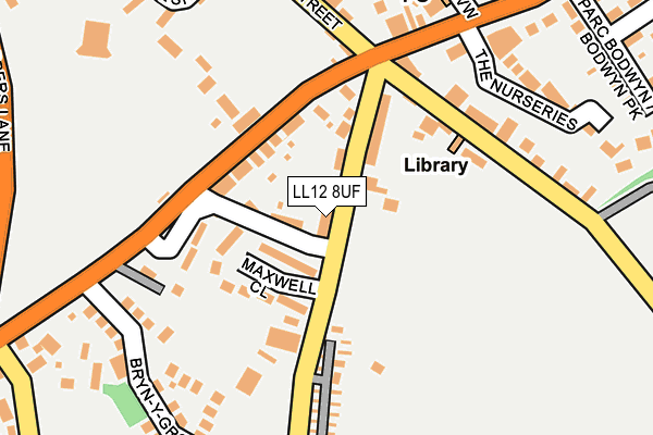
LL12 8UF lies on Westwood View in Gresford, Wrexham. LL12 8UF is located in the Gresford East and West electoral ward, within the unitary authority of Wrexham and the Welsh Parliamentary constituency of Wrexham. The Local Health Board is Betsi Cadwaladr University and the police force is North Wales. This postcode has been in use since January 1980.


GetTheData
Source: OS OpenMap – Local (Ordnance Survey)
Source: OS VectorMap District (Ordnance Survey)
Licence: Open Government Licence (requires attribution)
| Easting | 334940 |
| Northing | 354505 |
| Latitude | 53.083799 |
| Longitude | -2.972766 |
GetTheData
Source: Open Postcode Geo
Licence: Open Government Licence
| Street | Westwood View |
| Locality | Gresford |
| Town/City | Wrexham |
| Country | Wales |
| Postcode District | LL12 |
| ➜ LL12 open data dashboard ➜ See where LL12 is on a map ➜ Where is Gresford? | |
GetTheData
Source: Land Registry Price Paid Data
Licence: Open Government Licence
Elevation or altitude of LL12 8UF as distance above sea level:
| Metres | Feet | |
|---|---|---|
| Elevation | 70m | 230ft |
Elevation is measured from the approximate centre of the postcode, to the nearest point on an OS contour line from OS Terrain 50, which has contour spacing of ten vertical metres.
➜ How high above sea level am I? Find the elevation of your current position using your device's GPS.
GetTheData
Source: Open Postcode Elevation
Licence: Open Government Licence
| Ward | Gresford East And West |
| Constituency | Wrexham |
GetTheData
Source: ONS Postcode Database
Licence: Open Government Licence
| March 2023 | Other theft | On or near Springfield Court | 460m |
| February 2023 | Burglary | On or near Park/Open Space | 301m |
| June 2022 | Other theft | On or near Petrol Station | 120m |
| ➜ Get more crime data in our Crime section | |||
GetTheData
Source: data.police.uk
Licence: Open Government Licence
| Plough Inn (Chester Road) | Gresford | 127m |
| Plough Inn (Chester Rose) | Gresford | 175m |
| Cross Trees House (Chester Road) | Gresford | 315m |
| Cross Trees House (Chester Road) | Gresford | 316m |
| Narrow Lane (Chester Road) | Gresford | 467m |
| Gwersyllt Station | 3.3km |
| Wrexham General Station | 4.2km |
| Cefn-y-Bedd Station | 4.2km |
GetTheData
Source: NaPTAN
Licence: Open Government Licence
| Percentage of properties with Next Generation Access | 100.0% |
| Percentage of properties with Superfast Broadband | 100.0% |
| Percentage of properties with Ultrafast Broadband | 0.0% |
| Percentage of properties with Full Fibre Broadband | 0.0% |
Superfast Broadband is between 30Mbps and 300Mbps
Ultrafast Broadband is > 300Mbps
| Percentage of properties unable to receive 2Mbps | 0.0% |
| Percentage of properties unable to receive 5Mbps | 0.0% |
| Percentage of properties unable to receive 10Mbps | 0.0% |
| Percentage of properties unable to receive 30Mbps | 0.0% |
GetTheData
Source: Ofcom
Licence: Ofcom Terms of Use (requires attribution)
GetTheData
Source: ONS Postcode Database
Licence: Open Government Licence


➜ Get more ratings from the Food Standards Agency
GetTheData
Source: Food Standards Agency
Licence: FSA terms & conditions
| Last Collection | |||
|---|---|---|---|
| Location | Mon-Fri | Sat | Distance |
| Westminster Drive | 16:00 | 09:30 | 670m |
| Singrett Hill | 16:15 | 09:45 | 1,453m |
| Forest Road | 11:00 | 10:15 | 1,842m |
GetTheData
Source: Dracos
Licence: Creative Commons Attribution-ShareAlike
| School | Phase of Education | Distance |
|---|---|---|
| All Saints Primary School School Hill, Gresford, Wrexham, LL12 8RW | Not applicable | 453m |
| The Rofft C.P. School Wynnstay Lane, Marford, Wrexham, LL12 8LA | Not applicable | 1.1km |
| Barker's Lane C.P. School Barker's Lane, Wrexham, LL13 9TP | Not applicable | 1.8km |
GetTheData
Source: Edubase
Licence: Open Government Licence
The below table lists the International Territorial Level (ITL) codes (formerly Nomenclature of Territorial Units for Statistics (NUTS) codes) and Local Administrative Units (LAU) codes for LL12 8UF:
| ITL 1 Code | Name |
|---|---|
| TLL | Wales |
| ITL 2 Code | Name |
| TLL2 | East Wales |
| ITL 3 Code | Name |
| TLL23 | Flintshire and Wrexham |
| LAU 1 Code | Name |
| W06000006 | Wrexham |
GetTheData
Source: ONS Postcode Directory
Licence: Open Government Licence
The below table lists the Census Output Area (OA), Lower Layer Super Output Area (LSOA), and Middle Layer Super Output Area (MSOA) for LL12 8UF:
| Code | Name | |
|---|---|---|
| OA | W00001976 | |
| LSOA | W01000370 | Wrexham 020G |
| MSOA | W02000420 | Wrexham 020 |
GetTheData
Source: ONS Postcode Directory
Licence: Open Government Licence
| LL12 8UE | Moss Side | 17m |
| LL12 8UG | Oakfield Cottages | 21m |
| LL12 8TP | South View | 49m |
| LL12 8UH | Lynfield | 49m |
| LL12 8UD | Maxwell Close | 66m |
| LL12 8UL | Peveril Cottages | 72m |
| LL12 8TN | Chester Road | 91m |
| LL12 8UN | Montrose Terrace | 97m |
| LL12 8TL | Chester Road | 140m |
| LL12 8UP | Holt Terrace | 160m |
GetTheData
Source: Open Postcode Geo; Land Registry Price Paid Data
Licence: Open Government Licence